CFHC Talkback For News Story #119:
Newest Talkback: 02:40 AM 09-30 EDT

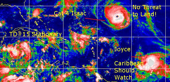
TD#15 Forms in Northwest Caribbean
05:38 PM EDT - 28 September 2000

Tropical Depression #15 is moving very slowly, and is basically stationary at the moment. I expect it to slowly move northwest and gradually strengthen into a hurricane. It would be Keith. It's slow movement will probably make it and Joyce stories in the future.

Isaac is just amazing. It's now a Category 4 system with 140MPH winds. Isaac, by far, is the most impressive looking storm of this season to date. Fortunately for everyone except sailors, it's a non-issue.

Joyce is starting to look as if it may have some sort of impact on the Northeast Caribbean Islands in roughly 3 to 4 days. It may skirt or cross, but it'll be a close call for sure. Folks in these islands will want to watch.

TD#15 is near Honduras right now and barely moving. There are no tropical storm watches or warnings yet, but folks in the Northwest Caribbean will want to watch it very closely. The rest of us will have to wait, as it is a slow mover, and will be hard to tell.

Issac and Joyce and TD#15 28 Sept 2000 5PM

Comments or Questions? Everyone is invited to use it. Use the comment button by the story Headline.


NRL Monterey Marine Meteorology Division Forecast Track of Active Systems (Good Forecast Track Graphic and Satellite Photos)
Map with nearly all model projected tracks plotted for Isaac., Joyce, or TD#15 From Michael Bryson.
Crown Weather Services Tropical Update (Includes Map with multiple forecast model tracks)
Snonut's Hurricane Reports
Satellite images at: [Visible] (visible -- Daytime Only) [Infrared] (infrared), and [Water Vapor] (water vapor)
Loops: Visible Loop - Infrared Loop - Water Vapor Loop
NASA GHCC Interactive Satellite images at:
[NAtl visible] (visible -- Daytime Only) [NAtl infrared] (infrared), and [NAtl water vapor] (water vapor)--Nasa source.
Ocean Surface Winds Derived from the SeaWinds Scatterometer (Experimental)
StormCarib.com has reports from folks in the Caribbean islands themselves and is worth checking out when storms approach the Caribbean.
Ouragans.com Français -- L'information sur des ouragans comprenant beaucoup de liens.
Tormenta.net Español -- Gran información sobre huracanes aquí.

Some Forecast models: (NGM, AVN, MRF, ECMWF, ETA)
DoD weather models (NOGAPS, AVN, MRF)
AVN, ECMWF, GFDL, NOGAPS, UKMET

- [mac]


Show All Comments

Displaying Talkbacks #1 - #14 (of 14 total)

Hugo 89' or Georges 98' ? (#1)
Posted by:
R.A.D (http://flhurricane.com/rad) Location: St Petersburg, Florida
Posted On 05:53PM 28-Sep-2000 with id (RTNRXNRNSY*)


http://files.hurricanealley.net/images/14lhist.jpg what can we expect from joyce

TD 15 (#2)
Posted by: Alex K
Posted On 06:01PM 28-Sep-2000 with id (VSNTRNQTQNVS*)


For a 30 mph tropical depression, 70 miles off the coast, TD 15 has a good circulation, and pretty good outflow.

U. S. Watch Out (#3)
Posted by: Robert Location: West Palm Beach
Posted On 06:14PM 28-Sep-2000 with id (QURNQVSNRPVNQYQ*)


For all of you that thought the season was over, what a difference a few weeks makes. We could have 2 hurricanes approaching different parts of the U.S. sometime next week. WOW !!!!!


WHY??? (#4)
Posted by:
Richard Byett (http://www.stormwarn2000.com) Location: Gloucester, England, UK
Posted On 06:22PM 28-Sep-2000 with id (RQRNQSYNTPNRQY*)


Why is it that now i will be off on holiday, and therefore unable to update my site next week, everything starts happening

Why? Because! (#5)
Posted by:
John C. (http://www.flhurricane.com) Location: Cocoa, FL
Posted On 06:28PM 28-Sep-2000 with id (VUNSSNQYNRTR*)


Belive me Richard we know what you mean!

KEITH??? (#6)
Posted by:
LONNY Location: HOLLYWOOD,FL
Posted On 07:25PM 28-Sep-2000 with id (QURNQVSNRPTNRP*)


Any views on the future of soon to be Keith? I haven't seen any models but I remember a couple a days ago they wanted to develope a system and head it NNE. Now they say stationary and then NW.Is this a Gulf storm or is it going straight up thru Cuba

Joyce has gotten "Bigger" (#7)
Posted by: Gary Location: Los Angeles
Posted On 08:56PM 28-Sep-2000 with id (VSNRUUNTQNQST*)


Has anyone noticed that Joyce is now about the same size as Isaac in terms of its area of convection?

Keith and Joyce (#8)
Posted by:
Colleen Location: Lakeland, Florida
Posted On 08:59PM 28-Sep-2000 with id (RPUNQXXNQYWNQUS*)


Well, Keith, I think will drift NW slowly..and all eyes should be upon him as he does so...because I think this has a chance to become a strong hurricane (don't ask me why, I just do),,,and Joyce, well, Joyce worries me too...she is beginning to develop what looks like and eye now, and could be a major hurricane in a few days time.

time to keep an eye to the sky....

(and watch out for the flying dynagel :-)

p.s...if the storms get too close to home, we could all throw Pampers at them!!!!

Just a poking a little humor at myself. And Enjoying it. Immensely.

Colleen

Ready and able (#9)
Posted by: Gary (
http://†) Location: Hernando Beach
Posted On 09:19PM 28-Sep-2000 with id (RTNQVTNVNRTV*)


I went to the store and bought 200 cans of shaving cream just in case. My boat is ready to go out and protect my shore line I might be a hero....LOL .....anyway our TD looks sick right now but I think that will change


Model runs TD# 15 (#10)
Posted by: Gary (
http://†) Location: Hernando Beach
Posted On 09:31PM 28-Sep-2000 with id (RTNQVTNVNRTV*)


DISCLAIMER...NUMERICAL MODELS ARE SUBJECT TO LARGE ERRORS.

PLEASE REFER TO TPC/NHC OFFICIAL FORECASTS FOR TROPICAL CYCLONES.


NATIONAL HURRICANE CENTER NORTH ATLANTIC OBJECTIVE AIDS FOR


TROPICAL DEPRESSION FIFTEEN (AL1500) ON 20000929 0000 UTC


...00 HRS... ...12 HRS... ...24 HRS...

000929 0000 000929 1200 000930 0000


LAT LON LAT LON LAT LON

BAMD 16.2N 83.2W 16.4N 83.8W 16.8N 84.2W

BAMM 16.2N 83.2W 16.6N 83.6W 17.3N 84.0W

A90E 16.2N 83.2W 16.2N 83.2W 16.5N 83.6W

LBAR 16.2N 83.2W 16.5N 83.6W 17.6N 83.9W

SHIP 25KTS 32KTS 42KTS


...36 HRS... ...48 HRS... ...72 HRS...

000930 1200 001001 0000 001002 0000


LAT LON LAT LON LAT LON

BAMD 17.5N 84.6W 18.1N 84.8W 18.7N 85.6W

BAMM 18.3N 84.2W 19.2N 84.3W 20.5N 85.0W

A90E 17.1N 84.1W 18.2N 84.7W 19.1N 86.6W

LBAR 19.1N 84.2W 20.8N 84.3W 24.4N 83.2W

SHIP 52KTS 60KTS 72KTS


...INITIAL CONDITIONS...

LAT0 = 16.2N LON0 = 83.2W DIR0 = 0DEG SPD0 = 0KT

LATM12 = 16.0N LONM12 = 82.5W DIRM12 = 285DEG SPDM12 = 2KT

LATM24 = 16.5N LONM24 = 82.5W

WND0 = 25KT RMAXWD = 45NM WNDM12 = 25KT

CENPRS = 1004MB OUTPRS = 1011MB OUTRAD = 120NM SDEPTH = M

RD34NE = -9NM RD34SE = -9NM RD34SW = -9NM RD34NW = -9NM


NNNN


T.D #15 (#11)
Posted by:
R.A.D (http://flhurricane.com/rad) Location: St Petersburg FL
Posted On 10:10PM 28-Sep-2000 with id (RTNRXNRNSY*)


GETTING THERE !http://www.nlmoc.navy.mil/cgi-bin/movie.pl?sat+jpg+10tttt+700+1000+carib+ir

test (#12)
Posted by:
Mike C. (http://flhurricane.com) Location: Newport News, VA (Currently)
Posted On 10:29PM 29-Sep-2000 with id (RTNRNUSNVY*)


test

test 5 (#13)
Posted by:
Mike C. (http://flhurricane.com) Location: Newport News, VA (Currently)
Posted On 10:38PM 29-Sep-2000 with id (RTNRNUSNVY*)


test 4

test 5 (#14)
Posted by:
Mike C. (http://flhurricane.com) Location: Newport News, VA (Currently)
Posted On 10:40PM 29-Sep-2000 with id (RTNRNUSNVY*)


test 4


Show All Comments


Return to Central Florida Hurricane Center Main Page