CFHC Talkback For News Story #47:
Newest Talkback: 06:30 AM 07-01 EDT

Droughtbusters!
09:47 AM EDT - 26 June 2001

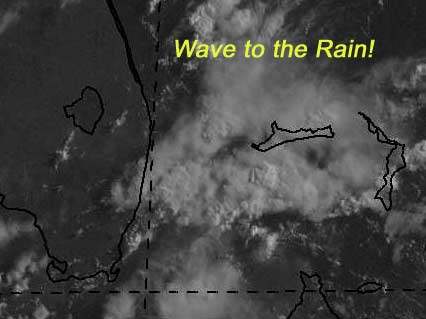
There is a tropical wave approaching south Florida now that will give us more much needed rain, and hopefully less lightning. It will start in south Florida and move northward, hopefully giving us a good soaking. We are still at drought levels despite all the afternoon storms. The storms have been lightning intense also.

My development potential scale for the wave approaching florida:

(forget it) 0 1 2 3 4 5 6 7 8 9 10 (sure thing)
           [-*--------------------]


The wave in the Caribbean is still there, but I doubt it will survive much longer.

My development potential scale for the wave in the Caribbean now:

(forget it) 0 1 2 3 4 5 6 7 8 9 10 (sure thing)
           [--*-------------------]


Let's all wave to our friends the droughbusters.


NASA GHCC Interactive Satellite images at:
[NAtl visible] (visible -- Daytime Only) [NAtl infrared] (infrared), and [NAtl water vapor] (water vapor)--Nasa source.
Defiant Visible Infrared More...
Some Forecast models: (NGM, AVN, MRF, ECMWF, ETA)
DoD weather models (NOGAPS, AVN, MRF)
AVN, ECMWF, GFDL, NOGAPS, UKMET

- [mac]


Show All Comments | Show Next 5 Comments | Show Previous 7 Comments

Displaying Talkbacks #6 - #10 (of 26 total)

convection (#6)
Posted by: solar
Posted On 04:21PM 27-Jun-2001 with id (QURNQVSNRPWNTW*)


I don't what I'm really talking about but what is that large area of convection in the western Gulf? Is this anything at all?

TWO @ 5:30pm (#7)
Posted by:
Colleen Location: Lakeland, FL
Posted On 05:54PM 27-Jun-2001 with id (RPUNQXXNRPPNQXT*)


Richard....notice the difference in their outlook from 11:30? It is now say "is CURRENTLY not expected." Before, I believe it just said, "not expected". What does that tell you? They're not sure either....even though the pressures are remaining high, I think they MIGHT be a little more concerned about development than earlier.

Than again...I am not an expert, lol!!!!

Colleen

Hello strangers (#8)
Posted by:
k___g Location: Orlando
Posted On 06:26PM 27-Jun-2001 with id (RTNRWNRRSNUS*)


Well, it's great to be back for another season of discussion with you all. Glad to see Colleen is still around....is Mike Anderson still posting?

Hey K_____G!!!! (#9)
Posted by:
Colleen Location: Lakeland, FL
Posted On 06:31PM 27-Jun-2001 with id (VTNQRNQPVNRS*)


Yes I am still around....I'll never leave!! LOL! And yes, Mike is still posting....there's a link to his website here...see ya later!!!

Colleen :-)

Heavy Rain Here!!! (#10)
Posted by: Joe Location: St.Petersburg, FL
Posted On 06:48PM 27-Jun-2001 with id (RQVNSNQXRNQTU*)


Severe Storms continue to move in from the west. I was looking at the nexrad radar out of Melbourne and boy was there a lot of rain offshore heading slowly west. Will something form out of this wave not to confident but won't rule it out for sure!

only trades, no barrys (#11)
Posted by: HankFrank Location: Aiken, SC
Posted On 01:46AM 28-Jun-2001 with id (RPTNQQVNQVNQPU*)


for all of the convection around florida and in the sw gulf, every reporting station i checked was showing a breeze from the east. just the trades, no incipient lows, no really persistent convection. shear keeps killing everything, the usual in june. with one june storm already, the chances of another are about 1 in 20.. that said, i'll probably still find myself eyeing the next convective ball that hangs around for 36 hours.. every now and then one of these teasers will become for real.
shouldnt have to wait more than a month for that to happen, i s'pose.. then come all the jokes and analogies to barry bonds.


Show All Comments | Show Next 5 Comments | Show Previous 7 Comments


Return to Central Florida Hurricane Center Main Page