CFHC Talkback For News Story #51:
Newest Talkback: 05:55 PM 07-08 EDT

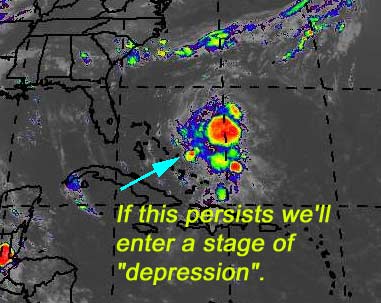
Upper Level Bahamas? Will it Persist?
09:51 AM EDT - 03 July 2001

There is a mostly upper level system near the Bahamas that has exploded this morning, and may want to take a dive and try to become a lower level system. Unlikely, still, (UL winds are rather high) but definitely worth watching during this holiday centered week. In either case it will bring rain and some wind to Florida later on this week. Development really depends on persistence again. If this keeps up (Especially overnight) then we may have something develop.

I'll be out of town the remainder of the week so access to the site will be spotty. If something develops we'll do our best.

My development potential scale for the wave approaching florida:

(forget it) 0 1 2 3 4 5 6 7 8 9 10 (sure thing)
           [-------*--------------]
Bad storm puns are comedy gold


NASA GHCC Interactive Satellite images at:
[NAtl visible] (visible -- Daytime Only) [NAtl infrared] (infrared), and [NAtl water vapor] (water vapor)--Nasa source.
Defiant Visible Infrared More...
Some Forecast models: (NGM, AVN, MRF, ECMWF, ETA)
DoD weather models (NOGAPS, AVN, MRF)
AVN, ECMWF, GFDL, NOGAPS, UKMET

- [mac]


Show All Comments | Show Next 6 Comments

Displaying Talkbacks #1 - #6 (of 48 total)

Persistance (#1)
Posted by:
Colleen Location: Lakeland
Posted On 10:00AM 03-Jul-2001 with id (VTNQRNQPUNQXR*)


is the key...unlike the Gulf system...this area has been persistant for over 2 days now, including last night. Remember, also..that if this does develop, it has a warm eddy + the Gulfstream to get through before it comes to visit...we need to be aware and pay attention to this one.

Hope you guys have a great Independence Day!
Colleen

Tropical Disturbance (#2)
Posted by: Mike
Posted On 10:34AM 03-Jul-2001 with id (RPXNUQNQQVNQTV*)


Weather channel is now calling this a mid level Tropical Disturbance. Any idea what that means? And does that mean they are taking it more seriously?

Mid Level Disturbance (#3)
Posted by: StormHound (
http://stormhound.homestead.com) Location: Orlando
Posted On 11:00AM 03-Jul-2001 with id (QRNSUNRRNQTP*)


Well, as I understand things, this means we are moving towards the possibility of a Tropical Depression. As stated above, this system has been primarily a high level system. A mid level system means it is moving down towards the surface. When we get to low level then we are at or close to being a Tropical Depression. Interesting news.

weather channel (#4)
Posted by:
alan Location: Orlando
Posted On 11:00AM 03-Jul-2001 with id (RPVNRQUNRRQNRUR*)


TWC is still saying tropical development is not favorable as of 10:50. Of course, we'll all see what is going on at 11:30.
After finally getting my loops to run, I don't see a strong circulation and it seems as if it is pulling to the north. Any circulation I see, seems to be a couple hundred miles to the north of where it was yesterday.

huh? (#5)
Posted by: scottsvb Location: Tampa
Posted On 11:06AM 03-Jul-2001 with id (RPUNQXXNQYSNTW*)


Actually Mark gave out the perfect reasons
why this wont form in the topic before. Midlevel
low also doesnt mean its coming down to the
surface it just is a retransformation of the
system. Anyways this system is tropical in
nature but wont be a serious system for
development. It will bring much needed rain
to Florida in a day or 2.

Alan (#6)
Posted by:
Colleen Location: Lakeland
Posted On 11:13AM 03-Jul-2001 with id (QURNQVSNRQSNTW*)


I think what you are seeing pulling to the north is not the circulation itself, but the convection. Like StormHound said, this is something that needs to carefully watched and the NHC has said as much in it's 8:00 discussion last night. Climatologically (sp?) speaking, this area is a favorable area for development this time of year...maybe all the ingrediants aren't there yet, but that doesn't mean we shouldn't pay attention to it.

Bahamas (#7)
Posted by: Joe Location: St.Petersburg, FL
Posted On 11:16AM 03-Jul-2001 with id (RQVNSNQXRNWY*)


Well convection still going in the area. As far as it becoming a tropical system I think fairly slim but needs to be watched. Shear is around 5 to 10kts near the convection but increases to 20kts or so in western bahamas. Never the less this system will up are rain chances starting tomorrow especially southeast coast of florida then east coast.


Show All Comments | Show Next 6 Comments


Return to Central Florida Hurricane Center Main Page