
Latest CFHC News
- See Less News...
The 2026 Atlantic Hurricane Season Begins Today
Posted: 06:43 AM 01 June 2026 | 2 Comments | Add Comment | Newest: 08:24 PM 02-Jun EDT
June 1st is the start of the official Atlantic Hurricane Season which runs until November 30th
This year is expected to be lower than average because of the el nino effect. This is basically a periodic event in the Pacific ocean that warms up temperatures there in the eastern Pacific, which tends to lower pressure there, and force trade winds to be stronger over the Atlantic, as well as the mid Atlantic back feed, which causes windshear and more stability in the atmosphere in general in the Atlantic, which dampens the hurricane season. However, it does not prevent it, some notable storms like hurricane Andrew happened in an El Nino year. So it's important to watch. It does favor storms doing odd tracks and patterns where it typically won't form as far out, for those that form.
In the near term although there is some moisture, there's nothing organized in the Atlantic that looks like it could develop in the next week or two. But the areas typically to watch this time of year are off the southeast coast and Gulf. Have a plan in place if you live in an evacuation area, and get be prepared now, not when a storm is bearing down on you.
Another year here 31st year for flhurricane.com. With some new features like the hurricane radar page on the left, focusing on Atlantic coastal hurricane radars (and Hawaii). We've also made it easier to share graphics like models, satellites and radar in the posts, just upload or even copy paste images into the forums this year, and crop/resize them right on the site.
Names for this year:
The National Hurricane center is the official source for advisories, warnings, and more, use https://nhc.noaa.gov for the best information. floridadisaster.org for emergency information in Florida. And local media (Tv, radio, papers, etc) for the best information for your particular area if the need arises.
Flhurricane stays away from hype and engagement farming, we do have social media on X and facebook, that we update when necessary. Posting long range modeling runs without context on the main site/socials is something we actively avoid since this we think is generally unhelpful and just causes confusion to highlight them. However, it doesn't mean they are not discussed, for those interested it can be found on the forecast lounge here on flhurricane.com.
There's nothing for the first week in the Atlantic, and over the next two weeks the most likely place to see development is not in the Atlantic, but in the east Pacific.
This year is expected to be lower than average because of the el nino effect. This is basically a periodic event in the Pacific ocean that warms up temperatures there in the eastern Pacific, which tends to lower pressure there, and force trade winds to be stronger over the Atlantic, as well as the mid Atlantic back feed, which causes windshear and more stability in the atmosphere in general in the Atlantic, which dampens the hurricane season. However, it does not prevent it, some notable storms like hurricane Andrew happened in an El Nino year. So it's important to watch. It does favor storms doing odd tracks and patterns where it typically won't form as far out, for those that form.
In the near term although there is some moisture, there's nothing organized in the Atlantic that looks like it could develop in the next week or two. But the areas typically to watch this time of year are off the southeast coast and Gulf. Have a plan in place if you live in an evacuation area, and get be prepared now, not when a storm is bearing down on you.
Another year here 31st year for flhurricane.com. With some new features like the hurricane radar page on the left, focusing on Atlantic coastal hurricane radars (and Hawaii). We've also made it easier to share graphics like models, satellites and radar in the posts, just upload or even copy paste images into the forums this year, and crop/resize them right on the site.
Names for this year:
Error reading wiki page. View on wiki
The National Hurricane center is the official source for advisories, warnings, and more, use https://nhc.noaa.gov for the best information. floridadisaster.org for emergency information in Florida. And local media (Tv, radio, papers, etc) for the best information for your particular area if the need arises.
Flhurricane stays away from hype and engagement farming, we do have social media on X and facebook, that we update when necessary. Posting long range modeling runs without context on the main site/socials is something we actively avoid since this we think is generally unhelpful and just causes confusion to highlight them. However, it doesn't mean they are not discussed, for those interested it can be found on the forecast lounge here on flhurricane.com.
There's nothing for the first week in the Atlantic, and over the next two weeks the most likely place to see development is not in the Atlantic, but in the east Pacific.
Today is the first day of the Eastern Pacific Hurricane Season. June 1st is the start of the Atlantic one, however the national hurricane center begins to issue advisories for
The Atlantic names this year are
This year we've fixed up a lot of formerly broken things, and working to recover more. The Hurricane Radar on the left is a fully custom set of radars for this site mimicking the old South Florida Water Management style, static, loops, and interactive map radar. Maps and Coordinates and Image Recordings have been improved, as well as the posts and replies, being easier (copy and paste) to bring in maps and images into the forum replies. The server has been moved and updated to be more modern as well.
Code:
The Atlantic names this year are
Error reading wiki page. View on wiki
with Leah replacing 2020's Laura.This year we've fixed up a lot of formerly broken things, and working to recover more. The Hurricane Radar on the left is a fully custom set of radars for this site mimicking the old South Florida Water Management style, static, loops, and interactive map radar. Maps and Coordinates and Image Recordings have been improved, as well as the posts and replies, being easier (copy and paste) to bring in maps and images into the forum replies. The server has been moved and updated to be more modern as well.
Code:
Tropical Weather Outlook

 NWS National Hurricane Center Miami FL

 800 AM EDT Fri May 15 2026


 For the North Atlantic...Caribbean Sea and the Gulf of America:


 Tropical cyclone formation is not expected during the next 7 days.


 Today, May 15, marks the first day of the routine issuance of the

 Atlantic basin Tropical Weather Outlook in 2026. This product

 describes significant areas of disturbed weather and their

 potential for tropical cyclone formation during the next seven

 days. The Tropical Weather Outlook is issued from May 15 through

 November 30 each year. The issuance times of this product are 2 AM,

 8 AM, 2 PM, and 8 PM EDT. After the change to standard time in

 November, the issuance times are 1 AM, 7 AM, 1 PM, and 7 PM EST.


 A Special Tropical Weather Outlook will be issued to provide

 updates, as necessary, in between the regularly scheduled issuances

 of the Tropical Weather Outlook. Special Tropical Weather Outlooks

 will be issued under the same WMO and AWIPS headers as the regular

 Tropical Weather Outlooks.


 A graphical version of the Tropical Weather Outlook is available on

 the web at: https://www.hurricanes.gov.
Dr Phil Klotzbach has released the Colorado state university numbers.
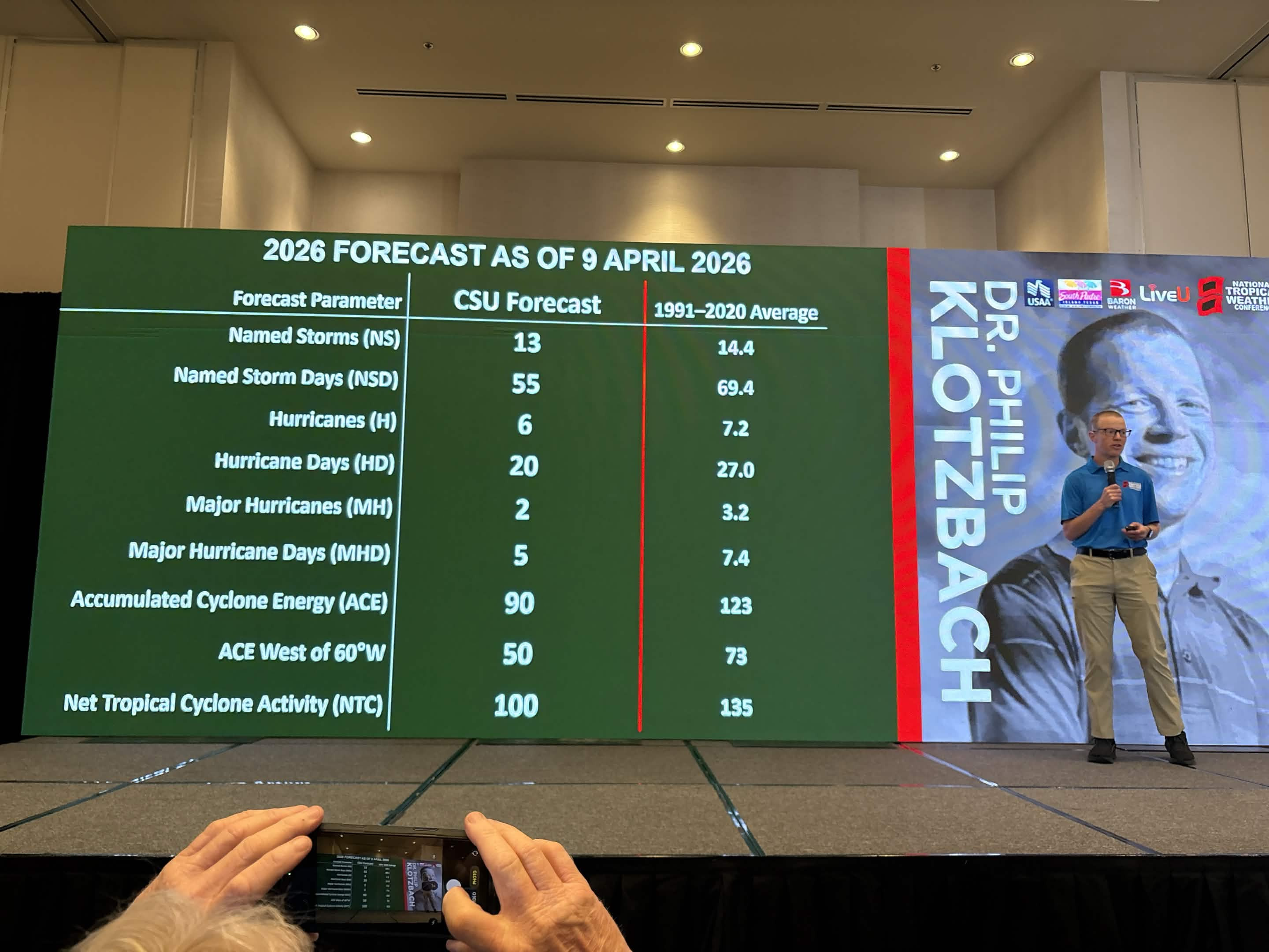
1. Seasonal Numbers at a Glance
CSU is projecting activity levels roughly 75% of a typical season.
2. The Florida Outlook: Landfall Probabilities
While the overall storm count is lower, Florida remains the most vulnerable state in the U.S. The 2026 report provides specific probabilities for major hurricane landfalls:
3. Primary Drivers: The "El Niño" Factor
The defining feature of the 2026 season is the transition from a weak La Niña to a moderate-to-strong El Niño during the peak months (August–October).
4. Historical Analogs
CSU identifies years with similar climate setups to help predict 2026’s behavior. The primary analog years are:
Your preparations should be identical to any other year. See https://www.floridadisaster.org/planprepare/preparing-for-hurricane-season/
One thing to note, this year has a higher chance for early season activity, even if only tropical storms. We'll be watching here at flhurricane.
This year we make it very easy to share images in posts, copy paste them in directly, or upload them for a button. You can then resize/crop them if you want. This is so you can share photos, satellites, model images and simple gif animations this year.
Windows folks can hit "Windows Key+Ctrl+S" to take snippets from your screen and then paste into here in the replies. more to come this year.
Reply here with your own guesses at numbers, which will close around the start of the season.
1. Seasonal Numbers at a Glance
CSU is projecting activity levels roughly 75% of a typical season.
- Named Storms: 13 (Average: 14.4)
- Hurricanes: 6 (Average: 7.2)
- Major Hurricanes (Cat 3+): 2 (Average: 3.2)
- Accumulated Cyclone Energy (ACE): 90 (Average: 123)
2. The Florida Outlook: Landfall Probabilities
While the overall storm count is lower, Florida remains the most vulnerable state in the U.S. The 2026 report provides specific probabilities for major hurricane landfalls:
- Florida Peninsula (South and East of Cedar Key): 15% (Long-term average: 21%)
- Gulf Coast and Panhandle (West of Cedar Key to Brownsville, TX): 20% (Long-term average: 27%)
- Proximity Risk: There is a 43% chance of a hurricane passing within 50 miles of Florida and a 21% chance of a major hurricane doing so.
3. Primary Drivers: The "El Niño" Factor
The defining feature of the 2026 season is the transition from a weak La Niña to a moderate-to-strong El Niño during the peak months (August–October).
- Wind Shear: El Niño typically creates high vertical wind shear across the Atlantic's Main Development Region (MDR). This "rips" storms apart before they can organize.
- Atmospheric Stability: Sinking air (subsidence) over the Caribbean and Atlantic is expected to suppress storm formation further.
- Atlantic Temperatures: While the Atlantic remains warm, it is not as anomalously hot as in recent record-breaking years, and the shear from El Niño is expected to be the dominant "hurricane slayer" this season.
4. Historical Analogs
CSU identifies years with similar climate setups to help predict 2026’s behavior. The primary analog years are:
- 2006 and 2009: Very quiet seasons for Florida landfall due to strong El Niño conditions.
- 2015: An extremely quiet year for the U.S. East Coast.
- 2023: A high storm count (20) but mostly storms that stayed out to sea, though Florida’s Big Bend was hit by Hurricane Idalia.
- Quality over Quantity: A below-average forecast does not mean zero risk. Forecasters frequently cite 1992 (Hurricane Andrew) as the ultimate warning: a very quiet, below-average year that produced one of the most devastating Category 5 landfalls in Florida history.
- Western Formation: Because El Niño suppresses storms in the deep tropics, 2026 may see more "homegrown" development in the Gulf of Mexico or Western Caribbean. These storms often have shorter lead times for us here in Florida.
Your preparations should be identical to any other year. See https://www.floridadisaster.org/planprepare/preparing-for-hurricane-season/
One thing to note, this year has a higher chance for early season activity, even if only tropical storms. We'll be watching here at flhurricane.
This year we make it very easy to share images in posts, copy paste them in directly, or upload them for a button. You can then resize/crop them if you want. This is so you can share photos, satellites, model images and simple gif animations this year.
Windows folks can hit "Windows Key+Ctrl+S" to take snippets from your screen and then paste into here in the replies. more to come this year.
Reply here with your own guesses at numbers, which will close around the start of the season.
Latest Meteorologist Blog - See More Blogs...
Ed Dunham
Hurricane Matthew Weather Summary for East Central Florida
Posted: 05:32 PM 16 October 2016
Hurricane Matthew passed just offshore of east-central Florida on the morning of October 7, 2016, as a Category III Major Hurricane with sustained winds of 115mph. The diameter of the eye at 5AM on Friday, October 7th, was 35NM and its location was 28.2N 80.0W or about 36 miles east of Patrick AFB with a movement to the north northwest at 13mph. Matthew moved parallel to the Florida coastline from Fort Pierce to Saint Augustine and then northward thereafter toward the South Carolina coast. Matthew never made landfall in Florida - the closest approach was at 6AM when the western edge of the eyewall brushed Cape Canaveral. Although the Tropical Storm force windfield was large, sustained winds of Hurricane strength only extended 40NM from the center on the western side of the tropical cyclone. Sustained hurricane force winds on land were confined to a small area at South Patrick Shores on the Barrier Island and a small area on the eastern tip of Cape Canaveral. In all other east central Florida coastal locations sustained winds of strong tropical storm force were observed. Storm total rainfall was generally in the 3 to 5 inch range except that some areas in Sanford received up to 9 inches of rain. Storm surge was in the 3 to 5 foot range along the east central Florida coast. During the storm, weather observations were not available from Indialantic, Patrick AFB, Cape Canaveral AFS and Titusville Airport - leaving a critical void in the meteorological record.
A low pressure reading of 28.97" was recorded at Melbourne NWS at 7AM. At 7:30AM I noted a pressure reading of 28.98" at my home in northwest Melbourne. The lowest pressure was located in the southern section of the eye of the hurricane and the central pressure from the Hurricane Hunters was recorded at 938MB (27.90") at 1AM. At 4AM the aircraft reported a circular eye with a diameter of 32NM and a central pressure of 942MB with flight level wind at 118 knots which translates to a 100 knot surface wind (115mph). At 7:17AM the aircraft sent a position fix for the eye at 28.6N 80.2W with a pressure of 942MB and eyewall sustained surface winds of 110 knots. The eye of Matthew had contracted to a circular 20NM diameter as the hurricane passed to the east of the area. Although the radius of the eye had contracted from 17NM to 10NM, the radius of sustained hurricane force winds remained at 40 miles to the west of the center. The central pressure increased and leveled off at 947MB during the day on Friday as Matthew moved NNW. If the eye of Matthew had moved along the shoreline, i.e., if it had been 35-40 miles further to the west, damage would have certainly been greater but no realistic conclusion can be made with regard to the extent of the destruction because an on-shore system would have slowly weakened.
Matthew goes into the record books as a Category I Hurricane in a small section of the Brevard County coast. In some reports from the NHC the flight level Recon wind speeds were not reduced correctly and resulted in stated maximum eyewall surface wind speeds that were about 10mph too high - and I cannot find a valid meteorological reason for doing this. Hurricane Erin in 1995 and Hurricanes Frances and Jeanne in 2004 were all storms with a greater impact on Brevard County. While the early call by the Brevard Emergency Management Operations Center to evacuate residents from the Barrier Islands was prudent, the overstated intensity and inland impacts were mis-leading and confusing to some of our residents. The National Hurricane Center and The Weather Channel both over-hyped the overall magnitude of the storm - which will not help folks to make the correct decision when the next hurricane visits our area. Matthew was not the catastrophic Category IV storm of the century that was touted by some for our area. All hurricanes are dangerous and deserve proper preparation and decision-making. It is worth noting that the area from Melbourne Beach to Titusville has never recorded a Cat III or greater hurricane. Someday that record of 165 years will probably be broken, but Matthew was not that storm. Hurricane David, September 3-4, 1979, was the last Category II Hurricane to hit this area with eye passage along the coast from West Palm Beach to New Smyrna Beach.
ED
Selected Weather Reports:
Vero Beach - wind W 49G74mph Rainfall 3.16"
Sebastian - wind N 30G59mph
5N Barefoot Bay - wind N G74mph
4NNW Grant - wind NW 51G68mph
Malabar - wind N 60G72mph
Melbourne Beach - wind N 23G63mph Lowest SLP: 28.85"
Melbourne (Dairy Road) - wind N 44G71mph
Melbourne - wind N 44G76mph Lowest SLP: 28.97"
NW Melbourne - wind NNW 42G65 Lowest SLP: 28.98 Storm Total Rainfall: 3.43"
Satellite Beach - wind N 69G87mph
2SSE Patrick AFB - wind N 69G88mph
South Patrick Shores - wind N 73G90mph Lowest SLP: 28.86"
Cocoa Beach Park - wind N 60G77mph
Merritt Island (Sunset Lakes) - wind NW 36G55mph Lowest SLP: 28.90"
Merritt Island (Banana River) - wind NNW 63G81mph
3WNW Cape Canaveral - wind gust N 86mph
4NE Cape Canaveral - wind gust NNW 81mph Coastal Flooding
5NE Port Canaveral - wind gust N 100mph
KSC Tower 22 - wind gust NW 107mph (non-standard anemometer height)
KSC Tower 3 - NNW 77G107mph (non-standard anemometer height)
Titusville (Parrish Park) - wind N 58G75mph
5NNE New Smyrna Beach - wind gust N 80mph
Daytona Beach (Speedway) - wind gust NNW 91mph
5NE Lake Mary - 24 hour rainfall 7.04"
Orlando Intl Airport - wind W 30G61mph Lowest SLP: 29.30"
From the Melbourne NWS:
G. STORM IMPACTS BY COUNTY...
---------------------------------------------------------------------
COUNTY DEATHS INJURIES EVACUATIONS
DESCRIPTION
---------------------------------------------------------------------
BREVARD 0 1 UNKNOWN
ONE DIRECT INJURY. A MALE IN HIS 40S WAS INJURED IN PORT CANAVERAL
WHEN A SIGN FELL AND STRUCK HIM DURING THE STORM. DAMAGE TO
BUSINESSES AND HOMES MAINLY AS A RESULT OF FALLEN TREES. SEVERAL
HOMES WITH WATER INTRUSION DUE TO DAMAGED ROOFS. TWO HOMES LOST TO
FIRE AS OFFICIALS SUSPENDED EMERGENCY SERVICES DURING THE HEIGHT OF
THE STORM. SPORADIC COUNTYWIDE DAMAGE TO FENCES...AWNINGS...AND
SCREEN ROOMS. AN INITIAL COASTAL SURVEY INDICATES MODERATE TO MAJOR
BEACH EROSION WITH SIGNIFICANT DAMAGE TO BERMS AND DUNES.
PRELIMINARY DAMAGE ASSESSMENT INDICATES AN ECONOMIC LOSS OF $25
MILLION DUE TO COASTAL EROSION, AND $4 MILLION DUE TO VEGETATIVE
LOSSES. PROPERTY DAMAGE ASSESSMENT HAS NOT BEEN COMPLETED. ABOUT
300,000 CUSTOMERS WERE WITHOUT POWER AT THE HEIGHT OF THE STORM.
INDIAN RIVER 0 0 UNKNOWN
NO DEATHS OR INJURIES. ROUGH SURF AND MAJOR BEACH EROSION.
PRELIMINARY BEACH DAMAGE ASSESSMENT DETAILS MAJOR DUNE EROSION AND
SIGNIFICANT DAMAGE TO PEDESTRIAN CROSSWALKS WITHIN COUNTY OWNED
BEACH PARKS WITH AN ESTIMATED ECONOMIC LOSS OF $13 MILLION. SEVERAL
HOMES DAMAGED MAINLY BY FALLEN TREES.
LAKE 0 0 UNKNOWN
NO DEATHS OR INJURIES. MINOR URBAN...ROADWAY...AND LOWLAND FLOODING.
THE ST. JOHNS RIVER NEAR ASTOR PEAKED JUST BELOW MODERATE FLOOD
STAGE. MINOR DAMAGE TO FOUR HOMES WITH MAJOR DAMAGE TO THREE CAUSED
MAINLY BY FALLING BRANCHES AND TREES. EARLY PROPERTY DAMAGE
ASSESSMENT OF APPROXIMATELY $389 THOUSAND.
MARTIN 0 1 UNKNOWN
ONE INDIRECT INJURY. A 47-YEAR-OLD MALE WAS ELECTROCUTED WHEN HIS
TOOLS HIT A LIVE POWER LINE WHILE TRIMMING TREES IN STUART AFTER
THE STORM ON MONDAY OCTOBER 10 AROUND 8:15 AM. ROUGH SURF AND MINOR
BEACH EROSION. MINOR DAMAGE TO HOMES MAINLY AS A RESULT OF FALLEN
TREES. ISOLATED DAMAGE TO FENCES...AWNINGS...AND SCREEN ROOMS.
PROPERTY DAMAGE ASSESSMENT NOT YET AVAILABLE.
OKEECHOBEE 0 0 UNKNOWN
NO DEATHS OR INJURIES. MINOR ROOF DAMAGE TO ONE HOME. UP TO 2300
CUSTOMERS WITHOUT POWER AT HEIGHT OF STORM.
ORANGE 1 0 UNKNOWN
ONE DEATH INDIRECTLY RELATED TO HURRICANE MATTHEW. A 70-YEAR-OLD
WOMAN DIED AFTER HER MEDICAL DEVICE FAILED DURING A POWER OUTAGE.
PROPERTY DAMAGE ASSESSMENT NOT YET AVAILABLE FROM OFFICIALS.
OSCEOLA 0 0 UNKNOWN
NO DEATHS OR INJURIES. NO REPORTS OF STRUCTURAL DAMAGE OR FLOODING.
MINOR DAMAGE MAINLY TO TREES AND VEGETATION. UP TO 5900 CUSTOMERS
WERE WITHOUT POWER AT THE HEIGHT OF THE STORM.
SEMINOLE 0 0 UNKNOWN
NO DEATHS OR INJURIES. MINOR URBAN...ROADWAY...LOWLAND AND RIVER
FLOODING. DAMAGE TO BUSINESSES AND RESIDENCES MAINLY BY FALLING
BRANCHES AND TREES. INITIAL PROPERTY DAMAGE ESTIMATED $15 MILLION.
UP TO 70,000 CUSTOMERS WITHOUT POWER AT THE HEIGHT OF THE STORM.
ST. LUCIE 2 2 UNKNOWN
TWO INDIRECT DEATHS AND TWO INDIRECT INJURIES. A 58-YEAR-OLD INDIAN
RIVER ESTATES WOMAN DIED OF A HEART ATTACK AND A PORT ST. LUCIE MAN
IN HIS 80S DIED AFTER SUFFERING BREATHING PROBLEMS AND SYMPTOMS OF A
STROKE AS FIRE OFFICIALS SUSPENDED EMERGENCY SERVICES DURING THE
HURRICANE. A 90-YEAR-OLD MALE AND FEMALE WERE FOUND UNCONSCIOUS IN
THEIR PORT ST. LUCIE HOME AFTER OFFICIALS DISCOVERED THEY WERE
RUNNING A GAS GENERATOR IN THEIR GARAGE. ROUGH SURF AND MODERATE TO
MAJOR BEACH EROSION. DAMAGE CONFINED MAINLY TO TREES...POWER
LINES...AND SIGNAGE THROUGH THE COUNTY. PROPERTY DAMAGE ASSESSMENT
NOT YET AVAIALBLE FROM OFFICIALS.
VOLUSIA 4 0 UNKNOWN
ONE DIRECT AND THREE INDIRECT FATALITIES. A 63-YEAR-OLD WOMAN DIED
WHEN A TREE FELL ON HER AS SHE WAS OUT FEEDING ANIMALS AT HER DELAND
HOME. A 89-YEAR-OLD MAN FROM DELEON SPRINGS WAS ELECTROCUTED BY A
DOWNED POWER LINE MONDAY MORNING AROUND 8:00 AM OCTOBER 10. A 47-
YEAR-OLD NORTHEAST OHIO MAN ASSISTING CLEANUP EFFORTS IN ORMOND
BEACH WAS KILLED WHEN PART OF A DOWNED TREE ROLLED ON TOP OF HIM AND
PINNED HIM UNDERNEATH. A 9-YEAR-OLD DAYTONA BEACH BOY WAS FOUND
UNCONSCIOUS IN HIS HOME AFTER OFFICIALS DISCOVERED A GENERATOR
RUNNING IN ANOTHER ROOM. THE BOY LATER DIED AT HALIFAX HEATLH
MEDICAL CENTER. SIGNIFICANT DAMAGE TO HOMES AND BUSINESS THROUGHOUT
THE COUNTY WITH OVER 6400 PROPERTIES AFFECTED, 1100 WITH MINOR
DAMAGE, 300 WITH MAJOR DAMAGE, AND 40 STRUCTURES DESTROYED. INITIAL
PROPERTY DAMAGE ESTIMATE OF $490 MILLION. ROUGH SURF AND MAJOR BEACH
EROSION. BEACH EROSION DAMAGE ASSESSMENTS NOT AVAILABLE AT THIS TIME.
General Links
Official / Primary
Storm Forum (community discussion)
Satellite / Observations
Data / Tracking / SST
Models
Other Commentary / Tools

