
Florida Water Week in the Tropics
Posted: 07:57 AM 30 June 2025 | 3 Comments | Add Comment | Newest: 07:58 PM 01-Jul EDT
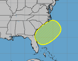
The primary impact of this area, which is a front that likely will stall out over the same area, along with next to steering currents and high water temperatures gives a ripe area for something to possibly develop. However, this something may try to form over land, and if it does, it won't become anything tropical. This is the most likely scenario. It does mean potential for a lot of rain all week, especially toward the end of the week, mostly along the north west coast of Florida and the panhandle, but also reaching across the peninsula, into southern Georgia, and extreme southeastern North and South Carolina. Meaning if you are in those areas, the likelihood of a washout for independence day is on the high side.
As for development, a lot depends on where something decides to form, if at all. Because of how broad the area is models aren't very good at picking up exactly where something may form. Some favor it leaning toward the Gulf side, some off the southeastern coast, and others split the difference over land, which translates into no tropical development.
To reflect this, tthe image below represents locations various models have picked up on.
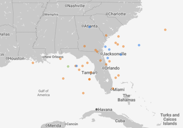
Image source Google Deepmind
Anything that shows up in the main line models means it's picking one of these and speculating on what happens. The spread means we'll have to watch it. Even if something forms, the likelihood of it becoming strong are slim, but if anything does it is imperative to keep watch to see how it drifts around in a low steering environment. In short, it needs to be watched all week in case it does consolidate, but most likely won't do much other than
rain.
Any Gulf area developing would be the most impactful, best case would be something offshore the southeast as it would likely wind up moving out to sea from there, unlikely to still be together if it got anywhere close to Bermuda.
As it stands now, the most likely outcome is no tropical development, with a lot of off/on rain.
Event Links
Long term radar recording of Florida for the entire length of the area
Tampa Area Media:
Jacksonville, FL Area Media:
Florida Panhandle Media/Links
WJHG TV 7 (NBC) Panama City Beach, FL
WMBB TV 13 (ABC) Panama City Beach, FL / My Panhandle
WTWC-DT2 49 (Fox) Tallahassee, FL
Newspapers Panama City Beach News Herald
Radio (some)
News Talk 94.5 WFLA Panama City Beach
]https://wflafm.iheart.com/ 100.7 WFLA News Radio Tallahassee, FL]
Power Outage
Barry in the Bay of Campeche
Posted: 02:49 PM 28 June 2025 | 4 Comments | Add Comment | Newest: 01:20 PM 29-Jun EDT
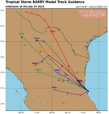
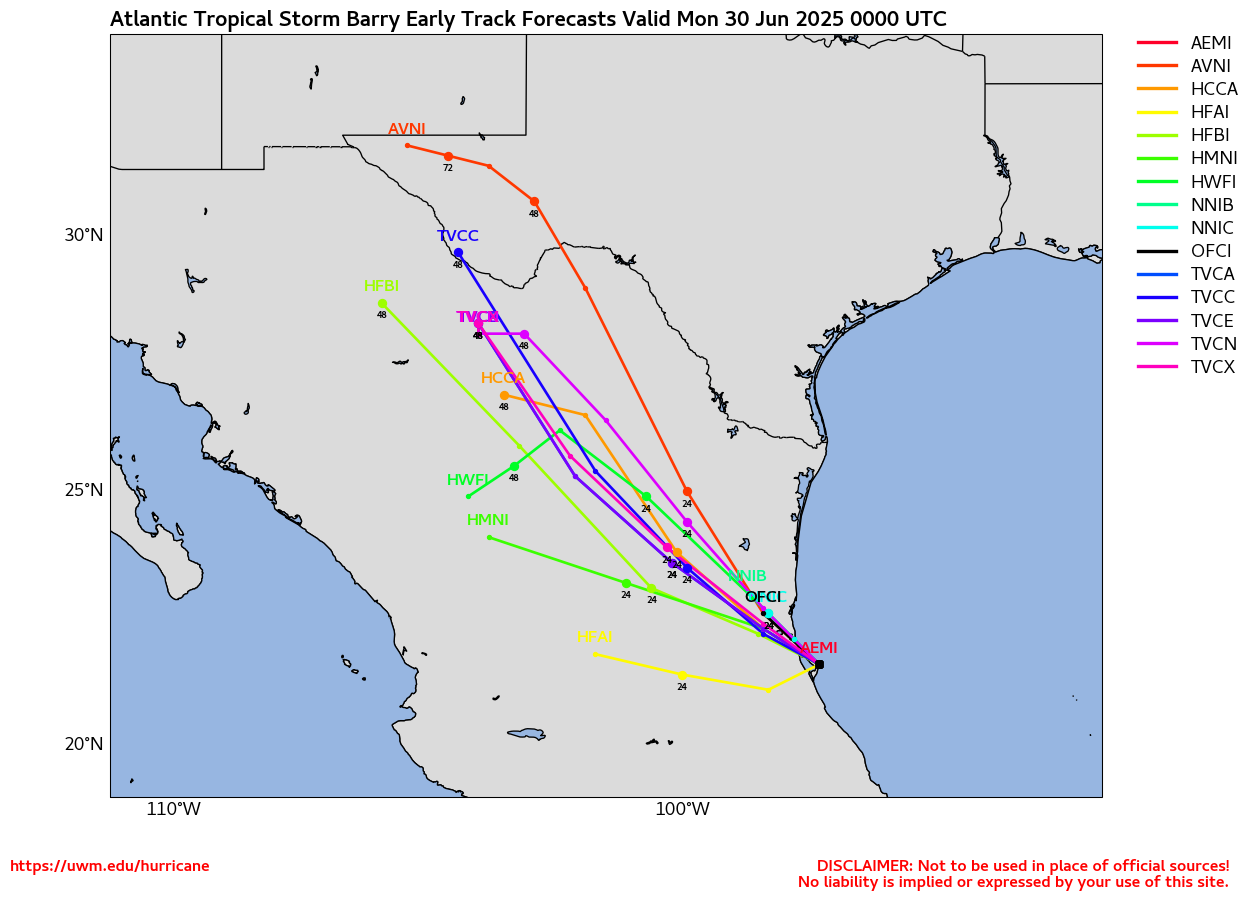
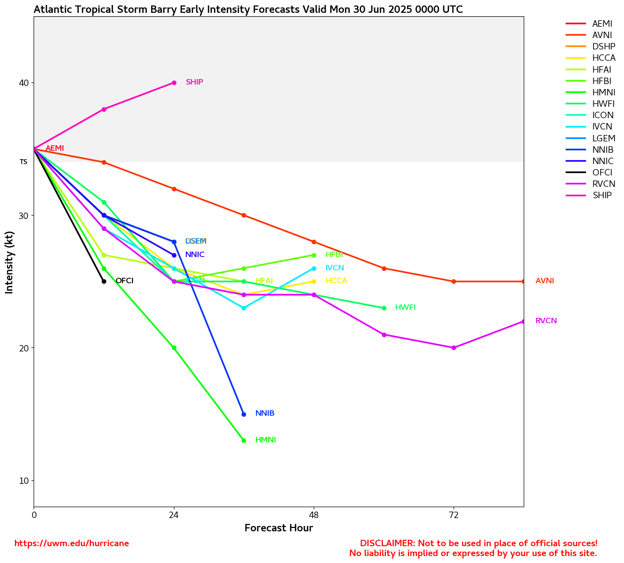
TD2 has just barely become Tropical Storm Barry, possibly the worst looking excuse for a name since way back to Andrea. Nonetheless, the cyclone qualifies and will likely produce very heavy rains and some flooding across inland eastern Mexico over the coming days.
Ciel
9AM EDT Update 29 June 2025
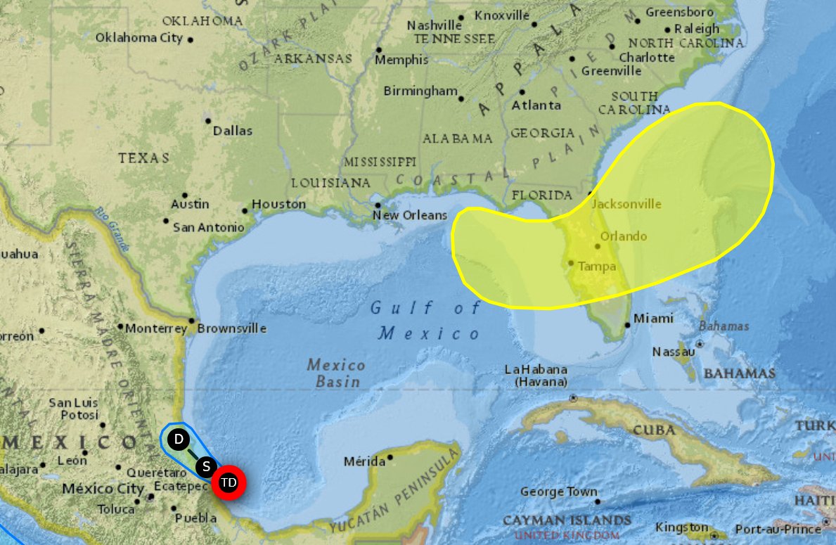
Tropical Depression 2 is in the Bay of Campeche now, still forecast to become a minimal tropical storm before landfall in Mexico. Next name is Barry.
There is a new yellow area along the northeast gulf extending over Florida into the Southeast with a 20% chance to develop over the next 7 days. Even if nothing develops from it quite a bit of heavy rain, particularly the end of the week, will be found in much of central and northern Florida and Georgia/South Carolina, including the July 4th holiday.
4PM CDT Update 28 June 2025
Invest 91L has become our second Tropical Cyclone of the year in the Atlantic basin, set to best climatology by over two weeks as the depression is forecast to become Tropical Storm Barry before making landfall along the eastern Mexican coastline late Sunday night or Monday. A Tropical Storm Warning is now in effect for the Gulf coast of Mexico from Boca de Catan southward to Tecolutla.
Original Update
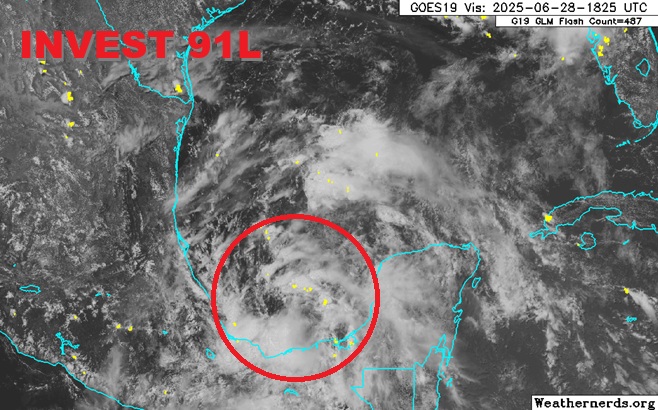
Base image credit: Weathernerds.org
Our second Invest-tagged feature of the 2025 Atlantic Hurricane Season is also likely to become our second named storm, unusual in getting back-to-back names out of the very first two Invests should this occur, and also unusual - although not as much so since 1995 - in that this would be well ahead of climatological average for our second name in this basin.
The next name on the list in 2025 is Barry. Interesting side note, the second named storm of 1995 was also Barry.
As of this new update, recon is presently sampling the area within and around Invest 91L and is also confirming that a well-defined circulation appears to be forming within the most recent blowup of convection. With this trend continuing, Tropical Storm Watches and/or Warnings may be issued for portions of the Mexican Gulf coast at any time.
We do already have a Forecast Lounge up on this one to delve deeper into the models and personal best guesses: Barry Lounge
Barry Event Related Links
Tropical Tidbits Page on system
Flhurricane Satellite Floater Animation of 2
GOES Floater
Tomer Berg Info page for 2
Cyclonix Wx Page for 2
Clark Evans Track Model Plot of 2
(Animated!) Model Plots in Google Earth - In Google Maps
Clark Evans Intensity Model Plot of 2 (Animated!)
Clark Evans Top 10 Analog Storms for 2
More model runs on from RAL/Jonathan Vigh's page
NRL Info on 2 -- RAMMB Info
COD Atlantic Satellite View
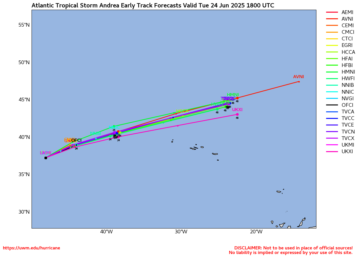
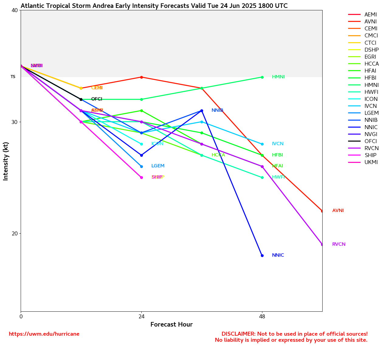
Short Lived Tropical Storm Andrea Forms East of Bermuda No Threat to Land
Posted: 10:19 AM 24 June 2025 | | Add Comment
Conditions for development of 91L appear to be going up and the system is now starting to move into the Bay of Campeche. Given its close proximity to land and what appear to be increasing odds of development, we have opened a Forecast Lounge (91L) for this one.
Ciel
5PM Update 27 June 2025
91L now being tracked over the Yucatan Peninsula with a 30% chance for development. Likely to be short lived if it develops at all, likely to landfall in Mexico near Tampico if it does.
Invest 91L Event Related Links
Tropical Tidbits Page on system
Flhurricane Satellite Floater Animation of 91
GOES Floater
Tomer Berg Info page for 91
Cyclonix Wx Page for 91
Clark Evans Track Model Plot of 91
(Animated!) Model Plots in Google Earth - In Google Maps
Clark Evans Intensity Model Plot of 91 (Animated!)
Clark Evans Top 10 Analog Storms for 91
More model runs on from RAL/Jonathan Vigh's page
NRL Info on 91 -- RAMMB Info
COD Atlantic Satellite View
Original Update
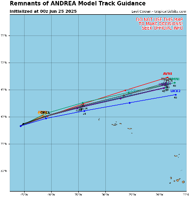
The area known as 90L has regained strength overnight, still sheared, but enough to be classified as the season's first Tropical Storm.
It is likely to remain short lived as the convection is getting sheared apart and moving into colder waters.
Andrea Event Related Links
Tropical Tidbits Page on system
Flhurricane Satellite Floater Animation of Andrea
GOES Floater
Tomer Berg Info page for Andrea
Cyclonix Wx Page for Andrea
Clark Evans Track Model Plot of Andrea
(Animated!) Model Plots in Google Earth - In Google Maps
Clark Evans Intensity Model Plot of Andrea (Animated!)
Clark Evans Track Plot of Andrea
Clark Evans Top 10 Analog Storms for Andrea
More model runs on from RAL/Jonathan Vigh's page
NRL Info on Andrea -- RAMMB Info
COD Atlantic Satellite View
Outside of this, nothing on the immediate horizon. Although area to watch int he next few weeks include the Bay of Campeche and off the Southeast coast, nothing is terribly likely to develop.
Atlantic Hurricane Season Starts Today and 30 Years of this Website
Posted: 06:50 AM 01 June 2025 | 3 Comments | Add Comment | Newest: 02:50 PM 05-Jun EDT
First invest area of the year is now in the Atlantic, east of Bermuda and unlikely to affect land.
It has a 20% chance to develop and is being tracked as invest 90L.
Invest Area 90L Event Related Links
Tropical Tidbits Page on system
Flhurricane Satellite Floater Animation of 90L
GOES Floater
Tomer Berg Info page for 90L
Cyclonix Wx Page for 90L
Clark Evans Track Model Plot of 90L
(Animated!) Model Plots in Google Earth - In Google Maps
Clark Evans Intensity Model Plot of 90L (Animated!)
Clark Evans Top 10 Analog Storms for 90L
More model runs on from RAL/Jonathan Vigh's page
NRL Info on 90L -- RAMMB Info
COD Atlantic Satellite View
10AM Update 4 June 2025
The area off the southeast is down to a near 0% chance to develop as most of the energy has moved inland, and will prevent tropical development. However the rain will continue.
Beyond this nothing really on the horizon, a lot of noise on the Bay of Campeche and West Caribbean, but nothing solid. Anything that may get going is most likely to wind up in the eastern Pacific.
2PM Update 2 June 2025
The area off the east coast now has a 10% chance for development of a short-lived system.
Original Update
Today marks the start of the 2025 Atlantic Hurricane season, and also marks the 30th anniversary of this website, which started in 1995.
The season runs through November 30, 2025.
This year also marks the 20th anniversary of Hurricane Katrina, which changes a lot for this site and many others. As it started as TD#10 in the Open Atlantic, fell apart, then regenerated into Katrina, made landfall in South Florida as a category 1 hurricane, then grew extremely large and became a strong hurricane, only starting to weaken right at landfall, but it was too late, the surge momentum was already there and in impacted coastal Mississippi the hardest, and caused New Orleans to take years to recover.
This hurricane season is forecast to be average, but it only takes one system to change that opinion.
This year's names are:
| Andrea | Humberto | Olga |
| Barry | Imelda | Pablo |
| Chantal | Jerry | Rebekah |
| Dexter | Karen | Sebastien |
| Erin | Lorenzo | Tanya |
| Fernand | Melissa | Van |
| Gabrielle | Nestorl | Wendy |
Andrea AN-dree uh Lorenzo loh-REN-zoh
Barry BAIR-ree Melissa meh-LIH-suh
Chantal shahn-TAHL Nestor NES-tor
Dexter DEHK-ster Olga OAL-guh
Erin AIR-rin Pablo PAHB-lo
Fernand fair-NAHN Rebekah reh-BEH-kuh
Gabrielle ga-bree-ELL Sebastien se-BAS-tee-en
Humberto oom-BAIR-toh Tanya TAHN-yuh
Imelda ee-MEHL-dah Van van
Jerry JEHR-ee Wendy WEN-dee
Karen KAIR-ren
The only new name on the list is Dexter, which replaced Dorian. Dorian impacted the northern Bahamas greatly as a slow moving Category 5, gave Florida a scare, and eventually had a second landfall in the outer banks of North Carolina..
Starting out there's a very small chance than an area that could show sometime next week in the Caribbean, but it's not likely to amount all that much, and there is time to watch it. Only the GFS model operational model shows it, but several ensembles from other models do. And it's more likely any energy winds up in the Eastern Pacific instead At this far out it's just something to watch, but the GFS is known for creating storms out of nothing this time of year. Another small, weak and short lived area could form off the Carolinas and move out to sea in a week or so.
Pre-Season 2025 and 30 Years
Posted: 07:34 AM 17 May 2025 | 1 Comment | Add Comment | Newest: 06:11 PM 30-May EDT
Flhurricane.com was born out of a passion for meteorology and a desire to provide accessible, hype-free hurricane information as much as possible. Founded in 1995 from the outdoor sportsman bbs during a relatively active year. It started out very simple. Mainly there wasn't much hurricane info in the early days of the internet and we started out being focused on central Florida (And still are) but early on we decided to stick to just the Atlantic basic.
In 1995 the internet as we know it was still very young. There were a few usenet newsgroups and gopher services with advisories. Snonut, and the ATWC (from now NHC employee Eric Blake), was about it, along with places like hurricane city that popped up shortly after. In 1996-1996 the actual flhurricane.com name began from Central Florida Hurricane Center. In 1999, it added more community features to fill a gap in the mid-1990s when detailed, community-driven hurricane resources were scarce. Unlike mainstream weather outlets, Flhurricane.com focused on delivering raw data, model outputs, and unfiltered discussions, with a particular emphasis on Florida, which faces more hurricane impacts than any other U.S. state.
WE wanted to break down advisories and discuss systems not driving for hype, click bait, or political reasons and focus on probabilities, without concern as to "clicks" driving sensationalism.
In its infancy, the site offered basic storm tracking tools, satellite imagery links, and a forum for weather enthusiasts to share insights. The internet was still young, and Flhurricane.com leveraged early web technologies to provide mostly articles allowing for commentary. We also built a database (that is still growing) of storms and advisories, as well as articles with the intent to archive them and keep them around.
2004-2005 was the "peak" of site activity mainly driven by active Florida hurricane years leading toward Katrina in 2005. SInce then the activity has leveled off, but the overall goal stayed the course. My current work keeps me from actively working on the site as much as I would like, but with assistance from others, it keeps going on the base goal of keeping information short and to the point. Although not always perfect, we try to keep the hype down and focus on what's going on. Not over or under emphasizing systems, and calling out areas that need to watch out.
If you are new or a long time viewer, thank you. We'll continue on as long as we can. And as always, this just is a supplement, please use the word of the National Hurricane Center for final decisions.
May 15th Tropical Weather outlooks began again, and nothing is on the radar for the preseason so far. The East Pacific may see something before the end of the month, but the Atlantic is looking pretty quiet in May so far.
Names for this year:
Andrea, Barry, Chantal, Dexter, Erin, Fernand, Gabrielle, Humberto, Imelda, Jerry, Karen, Lorenzo, Melissa, Nestor, Olga, Pablo, Rebekah, Sebastien, Tanya, Van, Wendy
Dexter is the only new name on this list as it replaced 2019's Hurricane Dorian (Which devastated parts of the Bahamas, particularly Abaco island and Grand Bahama) as a category 5, turning north just east of Florida and landfalling on the outer banks of North Carolina much weaker.
Ed Dunham
Hurricane Matthew Weather Summary for East Central Florida
Posted: 05:32 PM 16 October 2016
A low pressure reading of 28.97" was recorded at Melbourne NWS at 7AM. At 7:30AM I noted a pressure reading of 28.98" at my home in northwest Melbourne. The lowest pressure was located in the southern section of the eye of the hurricane and the central pressure from the Hurricane Hunters was recorded at 938MB (27.90") at 1AM. At 4AM the aircraft reported a circular eye with a diameter of 32NM and a central pressure of 942MB with flight level wind at 118 knots which translates to a 100 knot surface wind (115mph). At 7:17AM the aircraft sent a position fix for the eye at 28.6N 80.2W with a pressure of 942MB and eyewall sustained surface winds of 110 knots. The eye of Matthew had contracted to a circular 20NM diameter as the hurricane passed to the east of the area. Although the radius of the eye had contracted from 17NM to 10NM, the radius of sustained hurricane force winds remained at 40 miles to the west of the center. The central pressure increased and leveled off at 947MB during the day on Friday as Matthew moved NNW. If the eye of Matthew had moved along the shoreline, i.e., if it had been 35-40 miles further to the west, damage would have certainly been greater but no realistic conclusion can be made with regard to the extent of the destruction because an on-shore system would have slowly weakened.
Matthew goes into the record books as a Category I Hurricane in a small section of the Brevard County coast. In some reports from the NHC the flight level Recon wind speeds were not reduced correctly and resulted in stated maximum eyewall surface wind speeds that were about 10mph too high - and I cannot find a valid meteorological reason for doing this. Hurricane Erin in 1995 and Hurricanes Frances and Jeanne in 2004 were all storms with a greater impact on Brevard County. While the early call by the Brevard Emergency Management Operations Center to evacuate residents from the Barrier Islands was prudent, the overstated intensity and inland impacts were mis-leading and confusing to some of our residents. The National Hurricane Center and The Weather Channel both over-hyped the overall magnitude of the storm - which will not help folks to make the correct decision when the next hurricane visits our area. Matthew was not the catastrophic Category IV storm of the century that was touted by some for our area. All hurricanes are dangerous and deserve proper preparation and decision-making. It is worth noting that the area from Melbourne Beach to Titusville has never recorded a Cat III or greater hurricane. Someday that record of 165 years will probably be broken, but Matthew was not that storm. Hurricane David, September 3-4, 1979, was the last Category II Hurricane to hit this area with eye passage along the coast from West Palm Beach to New Smyrna Beach.
ED
Selected Weather Reports:
Vero Beach - wind W 49G74mph Rainfall 3.16"
Sebastian - wind N 30G59mph
5N Barefoot Bay - wind N G74mph
4NNW Grant - wind NW 51G68mph
Malabar - wind N 60G72mph
Melbourne Beach - wind N 23G63mph Lowest SLP: 28.85"
Melbourne (Dairy Road) - wind N 44G71mph
Melbourne - wind N 44G76mph Lowest SLP: 28.97"
NW Melbourne - wind NNW 42G65 Lowest SLP: 28.98 Storm Total Rainfall: 3.43"
Satellite Beach - wind N 69G87mph
2SSE Patrick AFB - wind N 69G88mph
South Patrick Shores - wind N 73G90mph Lowest SLP: 28.86"
Cocoa Beach Park - wind N 60G77mph
Merritt Island (Sunset Lakes) - wind NW 36G55mph Lowest SLP: 28.90"
Merritt Island (Banana River) - wind NNW 63G81mph
3WNW Cape Canaveral - wind gust N 86mph
4NE Cape Canaveral - wind gust NNW 81mph Coastal Flooding
5NE Port Canaveral - wind gust N 100mph
KSC Tower 22 - wind gust NW 107mph (non-standard anemometer height)
KSC Tower 3 - NNW 77G107mph (non-standard anemometer height)
Titusville (Parrish Park) - wind N 58G75mph
5NNE New Smyrna Beach - wind gust N 80mph
Daytona Beach (Speedway) - wind gust NNW 91mph
5NE Lake Mary - 24 hour rainfall 7.04"
Orlando Intl Airport - wind W 30G61mph Lowest SLP: 29.30"
From the Melbourne NWS:
G. STORM IMPACTS BY COUNTY...
---------------------------------------------------------------------
COUNTY DEATHS INJURIES EVACUATIONS
DESCRIPTION
---------------------------------------------------------------------
BREVARD 0 1 UNKNOWN
ONE DIRECT INJURY. A MALE IN HIS 40S WAS INJURED IN PORT CANAVERAL
WHEN A SIGN FELL AND STRUCK HIM DURING THE STORM. DAMAGE TO
BUSINESSES AND HOMES MAINLY AS A RESULT OF FALLEN TREES. SEVERAL
HOMES WITH WATER INTRUSION DUE TO DAMAGED ROOFS. TWO HOMES LOST TO
FIRE AS OFFICIALS SUSPENDED EMERGENCY SERVICES DURING THE HEIGHT OF
THE STORM. SPORADIC COUNTYWIDE DAMAGE TO FENCES...AWNINGS...AND
SCREEN ROOMS. AN INITIAL COASTAL SURVEY INDICATES MODERATE TO MAJOR
BEACH EROSION WITH SIGNIFICANT DAMAGE TO BERMS AND DUNES.
PRELIMINARY DAMAGE ASSESSMENT INDICATES AN ECONOMIC LOSS OF $25
MILLION DUE TO COASTAL EROSION, AND $4 MILLION DUE TO VEGETATIVE
LOSSES. PROPERTY DAMAGE ASSESSMENT HAS NOT BEEN COMPLETED. ABOUT
300,000 CUSTOMERS WERE WITHOUT POWER AT THE HEIGHT OF THE STORM.
INDIAN RIVER 0 0 UNKNOWN
NO DEATHS OR INJURIES. ROUGH SURF AND MAJOR BEACH EROSION.
PRELIMINARY BEACH DAMAGE ASSESSMENT DETAILS MAJOR DUNE EROSION AND
SIGNIFICANT DAMAGE TO PEDESTRIAN CROSSWALKS WITHIN COUNTY OWNED
BEACH PARKS WITH AN ESTIMATED ECONOMIC LOSS OF $13 MILLION. SEVERAL
HOMES DAMAGED MAINLY BY FALLEN TREES.
LAKE 0 0 UNKNOWN
NO DEATHS OR INJURIES. MINOR URBAN...ROADWAY...AND LOWLAND FLOODING.
THE ST. JOHNS RIVER NEAR ASTOR PEAKED JUST BELOW MODERATE FLOOD
STAGE. MINOR DAMAGE TO FOUR HOMES WITH MAJOR DAMAGE TO THREE CAUSED
MAINLY BY FALLING BRANCHES AND TREES. EARLY PROPERTY DAMAGE
ASSESSMENT OF APPROXIMATELY $389 THOUSAND.
MARTIN 0 1 UNKNOWN
ONE INDIRECT INJURY. A 47-YEAR-OLD MALE WAS ELECTROCUTED WHEN HIS
TOOLS HIT A LIVE POWER LINE WHILE TRIMMING TREES IN STUART AFTER
THE STORM ON MONDAY OCTOBER 10 AROUND 8:15 AM. ROUGH SURF AND MINOR
BEACH EROSION. MINOR DAMAGE TO HOMES MAINLY AS A RESULT OF FALLEN
TREES. ISOLATED DAMAGE TO FENCES...AWNINGS...AND SCREEN ROOMS.
PROPERTY DAMAGE ASSESSMENT NOT YET AVAILABLE.
OKEECHOBEE 0 0 UNKNOWN
NO DEATHS OR INJURIES. MINOR ROOF DAMAGE TO ONE HOME. UP TO 2300
CUSTOMERS WITHOUT POWER AT HEIGHT OF STORM.
ORANGE 1 0 UNKNOWN
ONE DEATH INDIRECTLY RELATED TO HURRICANE MATTHEW. A 70-YEAR-OLD
WOMAN DIED AFTER HER MEDICAL DEVICE FAILED DURING A POWER OUTAGE.
PROPERTY DAMAGE ASSESSMENT NOT YET AVAILABLE FROM OFFICIALS.
OSCEOLA 0 0 UNKNOWN
NO DEATHS OR INJURIES. NO REPORTS OF STRUCTURAL DAMAGE OR FLOODING.
MINOR DAMAGE MAINLY TO TREES AND VEGETATION. UP TO 5900 CUSTOMERS
WERE WITHOUT POWER AT THE HEIGHT OF THE STORM.
SEMINOLE 0 0 UNKNOWN
NO DEATHS OR INJURIES. MINOR URBAN...ROADWAY...LOWLAND AND RIVER
FLOODING. DAMAGE TO BUSINESSES AND RESIDENCES MAINLY BY FALLING
BRANCHES AND TREES. INITIAL PROPERTY DAMAGE ESTIMATED $15 MILLION.
UP TO 70,000 CUSTOMERS WITHOUT POWER AT THE HEIGHT OF THE STORM.
ST. LUCIE 2 2 UNKNOWN
TWO INDIRECT DEATHS AND TWO INDIRECT INJURIES. A 58-YEAR-OLD INDIAN
RIVER ESTATES WOMAN DIED OF A HEART ATTACK AND A PORT ST. LUCIE MAN
IN HIS 80S DIED AFTER SUFFERING BREATHING PROBLEMS AND SYMPTOMS OF A
STROKE AS FIRE OFFICIALS SUSPENDED EMERGENCY SERVICES DURING THE
HURRICANE. A 90-YEAR-OLD MALE AND FEMALE WERE FOUND UNCONSCIOUS IN
THEIR PORT ST. LUCIE HOME AFTER OFFICIALS DISCOVERED THEY WERE
RUNNING A GAS GENERATOR IN THEIR GARAGE. ROUGH SURF AND MODERATE TO
MAJOR BEACH EROSION. DAMAGE CONFINED MAINLY TO TREES...POWER
LINES...AND SIGNAGE THROUGH THE COUNTY. PROPERTY DAMAGE ASSESSMENT
NOT YET AVAIALBLE FROM OFFICIALS.
VOLUSIA 4 0 UNKNOWN
ONE DIRECT AND THREE INDIRECT FATALITIES. A 63-YEAR-OLD WOMAN DIED
WHEN A TREE FELL ON HER AS SHE WAS OUT FEEDING ANIMALS AT HER DELAND
HOME. A 89-YEAR-OLD MAN FROM DELEON SPRINGS WAS ELECTROCUTED BY A
DOWNED POWER LINE MONDAY MORNING AROUND 8:00 AM OCTOBER 10. A 47-
YEAR-OLD NORTHEAST OHIO MAN ASSISTING CLEANUP EFFORTS IN ORMOND
BEACH WAS KILLED WHEN PART OF A DOWNED TREE ROLLED ON TOP OF HIM AND
PINNED HIM UNDERNEATH. A 9-YEAR-OLD DAYTONA BEACH BOY WAS FOUND
UNCONSCIOUS IN HIS HOME AFTER OFFICIALS DISCOVERED A GENERATOR
RUNNING IN ANOTHER ROOM. THE BOY LATER DIED AT HALIFAX HEATLH
MEDICAL CENTER. SIGNIFICANT DAMAGE TO HOMES AND BUSINESS THROUGHOUT
THE COUNTY WITH OVER 6400 PROPERTIES AFFECTED, 1100 WITH MINOR
DAMAGE, 300 WITH MAJOR DAMAGE, AND 40 STRUCTURES DESTROYED. INITIAL
PROPERTY DAMAGE ESTIMATE OF $490 MILLION. ROUGH SURF AND MAJOR BEACH
EROSION. BEACH EROSION DAMAGE ASSESSMENTS NOT AVAILABLE AT THIS TIME.
Inside the Eye - Official National Hurricane Center Blog
RAMMB Interactive Satellite Imagery Morphed Integrated Microwave Imagery at CIMSS (MIMIC-TC)
NRL-Monterey (Nice Tracking Maps and Satellite)
Zoom Earth (Storm Tracks + Satellite Animation)
USNO Information on Current Storms (including Google Earth KMZ Files)
Best Track FTP, official source of invest data
Interactive Wundermap
San Jose State Models and More
Animated Earth Wind view of Tropical Atlantic
Check the Storm Forum from time to time for comments on any new developing system.
Follow worldwide SST evolution here: Global SST Animation - SST Forecast.
Google Deepmind models (New for 2025) -Atlantic Animation of Google Model
[url=https://tropic.ssec.wisc.edu/]CIMSS Tropical Weather[/ul]
Buoy
NASA MSFC North Atlantic Visible (Daytime Only), Infrared, Water Vapor
LSU Sat images, RAMSDIS Satellite Images (rapid-scan imagery)
Full Western Hemisphere Sat Animation
Buoy Data, Dvorak Estimates
Caribbean Weather Observations
Some forecast models:
NHC/TAFB Experimental Gridded Marine Forecast
Tomer Burg's mult-model ensemble plots
Multiple model output from Ryan Maue (HWRF, GFDL, GFS, etc)
GFS, ECMWF (ECMWF) and ECMWF Tropical Tidbits model page (GFS + more)
FSU: CMC, GFDL, GFS, NOGAPS, HWRF; Phase Analysis
DoD Weather Models (NOGAPS, AVN, MRF)
GFS, RUC, ETA
FIM Model
Raleighwx model page, Instant Weather Maps Models
Other commentary from Tropical Tidbits (Levi Cowan), Jeff Masters (Weather Underground) , Hurricanetrack.com (Mark Sudduth), Hurricane City (Jim Williams) , , WXRisk, TropicalAtlantic, Gary Gray's Millennium Weather, storm2k, Hardcoreweather, StormPulse (Matthew Wensing), , Mike's WX Page, Greg Nordstrom, Gulf Coast Weather, American Weather - 28 Storms Ham Weather, Suncam TV (Streaming Video/cams), Robert Lightbown/Crown Weather Tropical Update
NOAA Weather Radio
Even more on the links page.


