CFHC Talkback For News Story #51:
Newest Talkback: 05:55 PM 07-08 EDT

Upper Level Bahamas? Will it Persist?
09:51 AM EDT - 03 July 2001

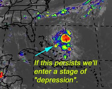
There is a mostly upper level system near the Bahamas that has exploded this morning, and may want to take a dive and try to become a lower level system. Unlikely, still, (UL winds are rather high) but definitely worth watching during this holiday centered week. In either case it will bring rain and some wind to Florida later on this week. Development really depends on persistence again. If this keeps up (Especially overnight) then we may have something develop.

I'll be out of town the remainder of the week so access to the site will be spotty. If something develops we'll do our best.

My development potential scale for the wave approaching florida:

(forget it) 0 1 2 3 4 5 6 7 8 9 10 (sure thing)
           [-------*--------------]
Bad storm puns are comedy gold


NASA GHCC Interactive Satellite images at:
[NAtl visible] (visible -- Daytime Only) [NAtl infrared] (infrared), and [NAtl water vapor] (water vapor)--Nasa source.
Defiant Visible Infrared More...
Some Forecast models: (NGM, AVN, MRF, ECMWF, ETA)
DoD weather models (NOGAPS, AVN, MRF)
AVN, ECMWF, GFDL, NOGAPS, UKMET

- [mac]


Show All Comments | Show Next 21 Comments | Show Previous 24 Comments

Displaying Talkbacks #7 - #27 (of 48 total)

Bahamas (#7)
Posted by: Joe Location: St.Petersburg, FL
Posted On 11:16AM 03-Jul-2001 with id (RQVNSNQXRNWY*)


Well convection still going in the area. As far as it becoming a tropical system I think fairly slim but needs to be watched. Shear is around 5 to 10kts near the convection but increases to 20kts or so in western bahamas. Never the less this system will up are rain chances starting tomorrow especially southeast coast of florida then east coast.

models and allison (#8)
Posted by:
alan Location: Orlando
Posted On 11:30AM 03-Jul-2001 with id (RPVNRQUNRRQNRUR*)


So the NHC says none of the models show it developing. Question for anyone because I was on vacation when Allison popped. Did any of the models show Allison forming? If so, how far out did they show it?
Thanks
Alan

no circulation (#9)
Posted by: Leo
Posted On 11:33AM 03-Jul-2001 with id (RPUNQXXNQYYNQVS*)


Calm down Colleen... NHC says no circulation...they are the best and official.

I'm Calm.... (#10)
Posted by:
Colleen Location: Lakeland
Posted On 11:42AM 03-Jul-2001 with id (QURNQVSNRQSNTW*)


just realistic....nothing wrong with that. As far as NHC being the "formal" information site, you are correct. I don't disagree with that at all. However, I also remember a storm named "IRENE" that was suppossed to hit the west coast of Florida according to the "models" and actually it was the Miami area that got slammed...and they weren't prepared. It was very obvious on sat pix that it wasn't going the way the models and the NHC insisted it was, but they never issued any warnings for the Miami area, which resulted in a lot of people that were put in harm's way needlessly.
Yes, they may be the "official" source; that doesn't mean they're perfect, either. I'm certainly not; as a matter of fact, looking at the loops now, I see what they are saying.


Calm down??? (#11)
Posted by:
alan Location: Orlando
Posted On 11:46AM 03-Jul-2001 with id (RPVNRQUNRRQNRUR*)


Just a reminder, this is a board for us to discuss what we are looking at with systems. No one says the people on the board are the official source. In fact, we always say go with the offical source.
But you can't deny that the NHC isn't always correct either. They, in fact, are using what they see to make an educated guess on what is happening, albeit a better guess than us amatuers make on the board.
So far, there has been no one saying this low will destroy Florida or that's it's absolutely going to develop. All we have been saying is that we should be watching it because of the level of convection, the water temps and the lack of wind shear.
No one that I have seen needs to calm down.

Circulation (#12)
Posted by: StormHound (
http://stormhound.homestead.com) Location: Orlando
Posted On 11:48AM 03-Jul-2001 with id (QRNSUNRRNQTP*)


I have to agree that at this point there doesn't seem to be much circulation and development doesn't seem all that likely. Conditions are somewhat favorable, however, so it is worth keeping an eye on.

great Job!! (#13)
Posted by: Joe Location: Port St. Lucie
Posted On 12:54PM 03-Jul-2001 with id (VTNQRNQPVNUR*)


I just wanted to say you all do a great job and have some great input you never get from "Official weather sources". I usually come here first and THEN go to the NHC. Keep up the good work!

Joe and Alan.... (#14)
Posted by:
Colleen Location: Lakeland
Posted On 01:04PM 03-Jul-2001 with id (VTNQRNQPVNTX*)


You're right...we wouldn't be here if we just wanted to depend on the NHC. Sometimes we're right, sometimes we're wrong. The point being, this forum was created by the site owners so we could discuss the tropics, not define them to a tee. If we were able to do that, we would be working at the NHC, not posting here.

And we all know how fast things can change with the NHC. Just look at Sunday, as an example.

Colleen :-)

I agree (#15)
Posted by: Alex K
Posted On 01:23PM 03-Jul-2001 with id (VSNRSRNQPRNXT*)


One thing I've learned studying hurricanes is that one should look for subtle things, because they may be the beginning of a trend. I in no means want to insult the NHC, but the tropical weather outlook for 5:30 am on June 5th was"Tropical storm formation is not expected through tommorrow." Note that Allison formed later that day.

Circulation Centre?? (#16)
Posted by:
Rich Byett (http://www.stormwarn2000.com) Location: Gloucester, England, UK
Posted On 01:40PM 03-Jul-2001 with id (RQSNQRRNQUYNQSY*)


JUst checked the latest visible image from the GHCC and zoomed in at 27.05w 72.04n.... this is the area where there is apparently a Circulation Centre. Please check this location, best to zoom in from the large image found at: www.ghcc.msfc.nasa.gov/GOES/goes8conus.html

Remember to centre it at, or very near to 27w 72n, and please let me know what you all think. Personaly i beleive it may make the transition to a Sub-tropical Depression / Storm possibly.

Rich
www.stormwarn2000.com/Hurrricane_Centre.htm

translation Please? (#17)
Posted by:
alan Location: Orlando
Posted On 02:25PM 03-Jul-2001 with id (RPVNRQUNRRQNRUR*)


Could anyone put this into English? It's the 2 p.m. tropical weather discussion.
thanks.

TROPICAL WAVE PREVIOUSLY ALONG 73W/74W IS NOW ALONG 74W/75W S OF 27N
AT 03/1200 UTC MOVING W 10-15 KT. WAVE IS INTERACTING WITH AN UPPER
LEVEL CYCLONIC CIRCULATION OVER THE WEST ATLC CREATING A COMPLEX
AREA OF DISTURBED WEATHER JUST E OF THE BAHAMAS. MOST OF THE
SIGNIFICANT CLOUDS/CONVECTION ARE WELL E OF THE WAVE AXIS IN
ASSOCIATION WITH DIVERGENCE E OF UPPER LOW. MORE
RECENTLY...ISOLATED THUNDERSTORMS HAVE FORMED ALONG THE AXIS.
ANALYSIS OF PAST UPPER LEVEL TIMESECTIONS OVER THE CARIBBEAN SHOWS
TWO FEATURES TRACKING WEST. THE FIRST FEATURE IS PRIMARILY IN THE
LOWER TO MID LEVELS BETWEEN 900-600 MB WITH A SURFACE WIND SHIFT
NOTED FURTHER E. A LOW-LEVEL/SURFACE WIND SURGE IS NOTED S OF 25N
EAST OF WAVE OVER THE ATLC AND E CARIBBEAN TO 55W. THE UPPER LEVEL
TURNING AHEAD OF THE SURFACE WAVE ALONG 74W/75W MAY BE A REFLECTION
OF THE UPPER LEVEL LOW THUS THE WAVE AXIS IS HELD ALONG THE SURFACE
WIND SHIFT/SURGE. DESPITE DECREASING UPPER LEVEL SUPPORT...WAVE
WILL ENHANCE LOW LEVEL MOISTURE AND SHOWER/THUNDERSTORM ACTIVITY
OVER THE N BAHAMAS...PORTIONS OF CENTRAL CUBA...AND SOUTH/CENTRAL
FLORIDA DURING THE NEXT 24 HRS AS IT CONTINUES WNW.


I'll try (#18)
Posted by: Alex K
Posted On 02:33PM 03-Jul-2001 with id (VSNRSRNQPQNQS*)


The wave is moving westward and is at about 75w. It has a mid level circulation and a surface wind shift has been noted farther east. I really don't know what a surface wind shift isCould a low level circulation be trying to form?

thanks (#19)
Posted by:
alan Location: Orlando
Posted On 02:39PM 03-Jul-2001 with id (RPVNRQUNRRQNRUR*)


That's the part I didn't get. What does a wind shift at 55W have to do with a wave at 75W?

strange (#20)
Posted by: Alex K
Posted On 02:44PM 03-Jul-2001 with id (VSNRSRNQPQNQS*)


I was closely studying the visible loop a few minutes ago. It appears that the circulation was moving w to wnw, but then it appeared to dissapate and reform moving northward.

Could it be trying to reform? (#21)
Posted by:
Colleen Location: Lakeland
Posted On 04:12PM 03-Jul-2001 with id (RPUNQXXNRPPNQXQ*)


It could be trying to reform further north, where it's more favorable; then again, I'm not a hurricane so I don't know what it's thinking.

(AND I AM NOT SAYING THIS WILL BE A HURRICANE)

Maybe the new NWS reports could give us a little insight here...

Colleen

Circulation (#22)
Posted by: Joe Location: St.Petersburg, FL
Posted On 04:15PM 03-Jul-2001 with id (RQVNSNQXRNVS*)


Well it appears to upper level low is moving north on the latest visible. Although moisture will be increasing over Florida as the wave comes closer to the state as south florida moisture already on increase. So Fourth may be wet for some folks over Florida. As far as as this system becoming a depression, I still think chances are low but will have to watch.


Key West NWS Discussion (#23)
Posted by:
Colleen Location: Lakeland
Posted On 04:49PM 03-Jul-2001 with id (QURNQVSNQYTNQYT*)


Is saying that winds are on the increase near Kings Bay? Bahamas, reporting 16knt winds out of the ene; before they were 10knts out of the east.
What does this mean? I'm not sure. Maybe it means that the wave is now moving to the WNW instead of W. Any thoughts?


Dead in the Water? (#24)
Posted by: Mike
Posted On 05:08PM 03-Jul-2001 with id (RPXNUQNQQVNQTV*)


Correct me if I'm wrong but it seems to be dead!

Upper low (#25)
Posted by: Joe Location: St.Petersburg, FL
Posted On 05:17PM 03-Jul-2001 with id (RQVNSNQXRNVS*)


Not sure what there saying colleen about the wind shift and speed. I though the upper low center was north of the bahamas, but key west nws said it's south.

sorry it's not going to happen (#26)
Posted by: Gary B Location: Hernando Beach
Posted On 05:37PM 03-Jul-2001 with id (RTNQVTNVNYY*)


TROPICAL STORM FORMATION IS NOT EXPECTED THROUGH WEDNESDAY

this (#27)
Posted by: scottsvb Location: Tampa
Posted On 05:54PM 03-Jul-2001 with id (QURNQVSNRPTNWW*)


Everyone is so funny in the posts. Keep
guessing guys I like that. Some guesses
are real good others well lets just leave
it at that. Generally its the same people
always saying that every wave is going to
form into a depression or storm or more and
will hit near they're city.
Well I feel they can post that or anything
in here, but I hope that some can try to
be more realistic.
As of now I still go with the people that say
this wont develop. The wind axis to the east
that they are talking about to 55W is a trough
from the upper low which near 27N. A reformed
mid level low is more near 24N and 73W moving
W-WNW and will start to affect florida over the
next 1-3 days. We need it especially in Central
and Western Florida.

thank you (#28)
Posted by: Leo
Posted On 06:02PM 03-Jul-2001 with id (RPUNQXXNRPPNQYP*)


Thank you scott...i couldn't have said it better myself.


Show All Comments | Show Next 21 Comments | Show Previous 24 Comments


Return to Central Florida Hurricane Center Main Page