Random Chaos
Weather Analyst

Reged:
Posts: 1024
Loc: Maryland
|
|
Chesapeake Bay tides:
I want to discuss the affect on the Chesapeake Bay. As a longtime resident with 40 miles of Northeast exposure, tides can make or break a storm. During Isabel, water was halfway to the house, but we got no waves. With , Francis, and Jeanne remnants, the water didn't rise, but the waves did damage to the bulkhead.
The Chesapeake Bay is very heavily affected by wind directions. The following general assumptions can be made:
1. If the storm tracks east of the bay, as the and most global models are showing, the western quadrant of the hurricane will blow water out of the Bay. The dominant wind directions will be Northeast, North, and Northwest, meaning that areas with Northeast exposure are most vulnerable due to the earlier impact of winds from that region of the storm, but as the storm continues, lower and lower tidal levels will cause the waves to have less and less impact. This is in many ways the best case scenario.
2. If the storm tracks west of the bay, as the is showing, then the eastern quadrant of the hurricane will blow water into the Bay, causing storm surge effects unrelated to the pressure of the storm. The dominant wind directions will be Southeast, South, and Southwest. Significant erosion will occur for any locations with East, South, or West exposure. Individuals with Northeast through Northwest exposure will be relatively safe from wave action, but may still experience significant flooding.
3. If the storm begins over the west of the bay, but transitions to the east of the bay, then all bets are off: we will get wind driven storm surge plus potential erosion on all regions of the storm.
Now remember I am talking about just wind driven surge effects and not pressure driven storm effects. Pressure effects may increase tidal height relative to just the wind driven scenario. The closer the storm passes to the mouth of the bay, the more affect on the bay the pressure will have. If the eye of the storm is inland, then the lowest pressure will be unable to drag as much water up the bay with it.
Chesapeake Bay Operational Forecast System - tide heights and wind speeds: http://tidesandcurrents.noaa.gov/ofs/cbofs/cbofs.html
Also note that a number of NOAA websites are hosted in the DC Metro area due to NOAA being headquartered in Bethesda, MD. With power outages, some NOAA websites might go down. Based on traceroutes, this looks to include the National Hurricane Center, the Satellite Services Division site (www.ssd.noaa.gov), and Weather.gov (including the radar websites). There may be backup locations for these servers.
Edited by Random Chaos (Thu Aug 25 2011 05:16 PM)
|
Random Chaos
Weather Analyst

Reged:
Posts: 1024
Loc: Maryland
|
|
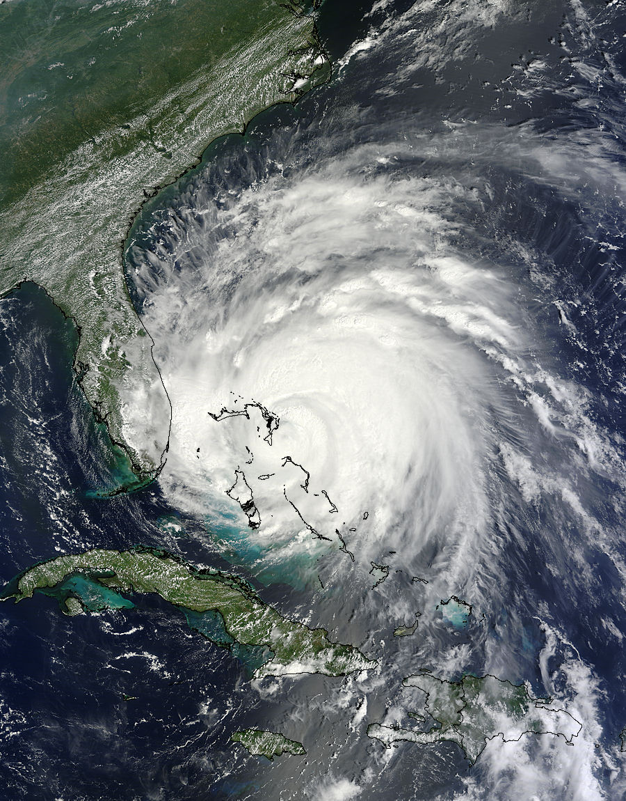
Our beauty today:

Large (1km resolution):
http://lance-modis.eosdis.nasa.gov/cgi-bin/imagery/single.cgi?image=Irene.A2011237.1550.1km.jpg
Larger (500m resolution):
http://lance-modis.eosdis.nasa.gov/cgi-bin/imagery/single.cgi?image=Irene.A2011237.1550.500m.jpg
Largest (250m resolution):
http://lance-modis.eosdis.nasa.gov/cgi-bin/imagery/single.cgi?image=Irene.A2011237.1550.250m.jpg
|
hurricane_run
Storm Tracker

Reged:
Posts: 366
Loc: USA
|
|
Its funny you mention this because I was just looking for a interesting article in the Baltimore Sun talking about how a major Hurricane landing in the Carolinas but particularly even a Cat 2 (i.e. Isabel) at the right angle crossing the bay could do significant damage.
Edit- Found article. Baltimore Sun Baltimore Sun Md Surge Article
Edited by hurricane_run (Thu Aug 25 2011 06:11 PM)
|
JMII
Weather Master

Reged:
Posts: 547
Loc: Cape Coral & Margate, FL
|
|
So is the thinking that front coming off the east coast right now will not be strong enough to nudge Irene back east? This front seems to be breaking up slightly (on the southern end), but it is still a pretty good sized one. It still appears (to me) that she'll miss (landfall) on the outer banks of NC.
|
Random Chaos
Weather Analyst

Reged:
Posts: 1024
Loc: Maryland
|
|
Last half hour has seen a marked improvement in satellite presentation, with a well defined, nearly clear eye appearing on both IR and Water Vapor imagery. Deeper convection is also firing around nearly the entire eyewall structure.
|
MikeC
Admin
Reged:
Posts: 4811
Loc: Orlando, FL
|
|
According to recon Pressure is down to 947, amazingly the eye is fairly solid (small break in the south) so it has another chance at strengthening tonight. There are a few factors that are negative for that, so it may hold, but the pressure dropping again is not a good sign for it getting weaker.
Recon fixes and satellite show the north northwest movement continuing
|
Random Chaos
Weather Analyst

Reged:
Posts: 1024
Loc: Maryland
|
|
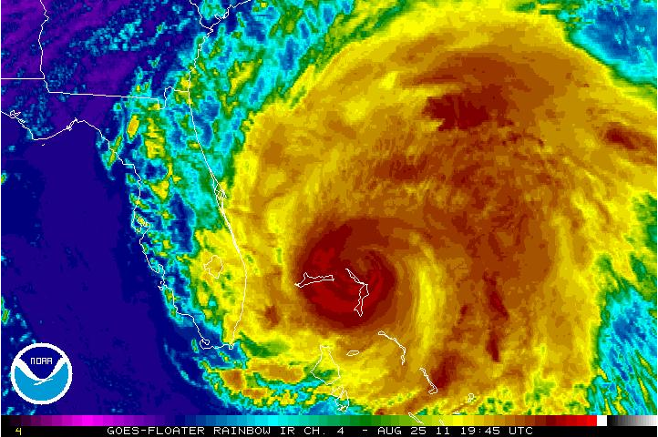
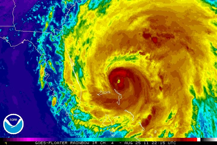
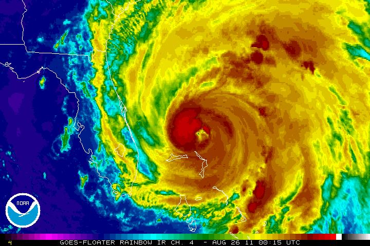
Irene is shedding outer convection on the NW, W, SW, and S sections of the storm. Outer convection is decreasing on the N, NE, E, and SE sections of the storm.
Inner core is intensifying and eye is becoming much clearer. Near bands to the core are wrapping tightly to the core and a trouh appears to be forming fully encircling the central storm where there still is outer convection.
It is beginning to take on an annular appearance to me. Anyone else see it? It's not there yet, but in another 1-2 hours it could be.
http://www.ssd.noaa.gov/goes/flt/t2/flash-rb.html
Note the change over time:
1945Z:

2215Z:

0015Z:

0115Z:

|
Random Chaos
Weather Analyst

Reged:
Posts: 1024
Loc: Maryland
|
|
HDOB extrapolated surface pressure just north of the calm FL winds was 937mb!
That's a huge drop in the past few hours, as dropsondes were showing 950mb only about 3-4 hours ago.
|
MikeC
Admin
Reged:
Posts: 4811
Loc: Orlando, FL
|
|
Quote:
HDOB extrapolated surface pressure just north of the calm FL winds was 937mb!
That's a huge drop in the past few hours, as dropsondes were showing 950mb only about 3-4 hours ago.
The wind really isn't going up with it right now, but it is going out (expanding) and probably building a huge amount of storm surge up to pile on wherever it makes land fall. Areas at and just to the right of the landfall point will probably see the worst of it. The other option is the wind lags behind pressure and speeds up later, both options are possible.
|
Random Chaos
Weather Analyst

Reged:
Posts: 1024
Loc: Maryland
|
|
Yep. Dropsonde measured 942mb surface pressure where HDOB was showing 942mb also, just south of the really low 937mb. My guess is the storm isn't perfectly vertically stacked, and the FL center is 5 miles south of the surface center. The eye is larger than that difference.
Winds are still barely Category 3, yet pressure is easily strong enough for a mid Category 4. So the wind field must be expanding rather than increasing in velocity, as Mike said.
Official vortex recon, using the dropsonde surface pressure:
Product: NOAA Vortex Message (URNT12 KWBC)
Transmitted: 26th day of the month at 02:16Z
Aircraft: Lockheed WP-3D Orion (Reg. Num. N42RF)
Storm Number: 09
Storm Name: Irene (flight in the North Atlantic basin)
Mission Number: 23
Storm Number & Year: 09L in 2011
Observation Number: 36
A. Time of Center Fix: 26th day of the month at 1:58Z
B. Center Fix Coordinates: 27°49'N 77°21'W (27.8167N 77.35W)
B. Center Fix Location: 184 miles (295 km) to the ENE (65°) from West Palm Beach, FL, USA.
C. Minimum Height at Standard Level: Not Available
D. Estimated (by SFMR or visually) Maximum Surface Wind: 82kts (~ 94.4mph)
E. Location of the Estimated Maximum Surface Wind: 13 nautical miles (15 statute miles) to the NNE (31°) of center fix
F. Maximum Flight Level Wind Inbound: From 128° at 99kts (From the SE at ~ 113.9mph)
G. Location of Maximum Flight Level Wind Inbound: 18 nautical miles (21 statute miles) to the NE (35°) of center fix
H. Minimum Sea Level Pressure: 942mb (27.82 inHg)
I. Maximum Flight Level Temp & Pressure Altitude Outside Eye: 17°C (63°F) at a pressure alt. of 2,445m (8,022ft)
J. Maximum Flight Level Temp & Pressure Altitude Inside Eye: 21°C (70°F) at a pressure alt. of 2,440m (8,005ft)
K. Dewpoint Temp (collected at same location as temp inside eye): 16°C (61°F)
K. Sea Surface Temp (collected at same location as temp inside eye): Not Available
L. Eye Character: Open in the southwest
M. Eye Shape & Diameter: Circular with a diameter of 25 nautical miles (29 statute miles)
N. Fix Determined By: Penetration, Radar, Wind, Pressure and Temperature
N. Fix Level: Other - Not surface, 1500ft, 925mb (if vortex is newer than about mid 90's; see note for more), 850mb, 700mb, 500mb, 400mb, 300mb or 200mb
O. Navigation Fix Accuracy: 1 nautical mile
O. Meteorological Accuracy: 1 nautical mile
Remarks Section:
Maximum Flight Level Wind: 111kts (~ 127.7mph) in the northeast quadrant at 21:25Z
Edited by Random Chaos (Thu Aug 25 2011 10:47 PM)
|
scottsvb
Weather Master
Reged:
Posts: 1184
Loc: fl
|
|
NHC has north at 350dg... I think its more like 360-5 dg... I see her at 28.3N and 77.2W moving almost due north. Over past 4hrs its gone actually .5 N and .1 East
|
MikeC
Admin
Reged:
Posts: 4811
Loc: Orlando, FL
|
|
11PM official forecast is pretty much the same, although it keeps Irene at hurricane Status even into central Massachusetts and southern New Hampshire.
|


 Threaded


