MikeC
Admin
Reged:
Posts: 4544
Loc: Orlando, FL
|
|
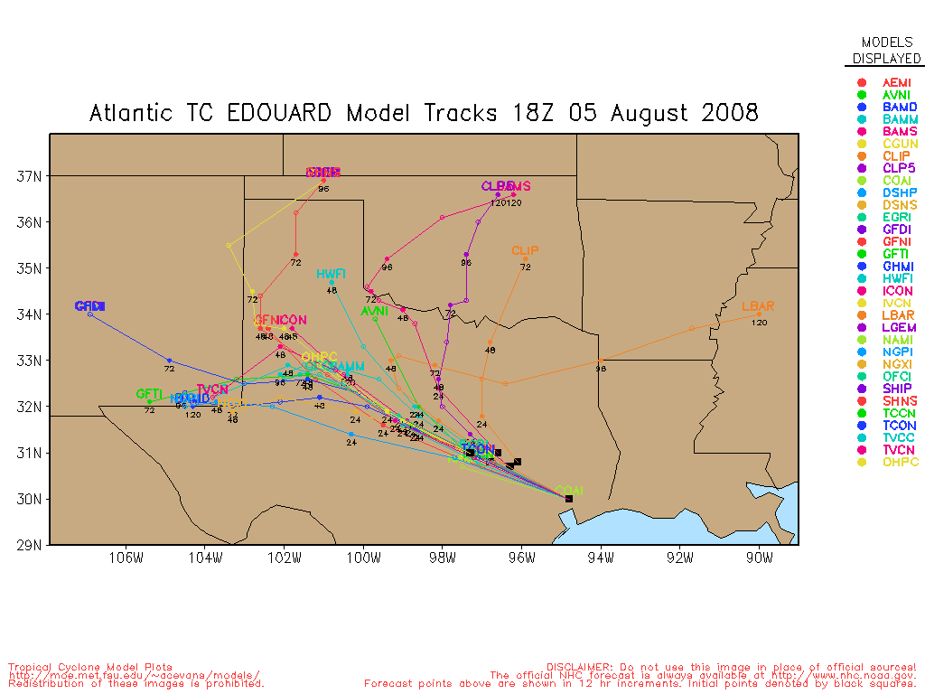
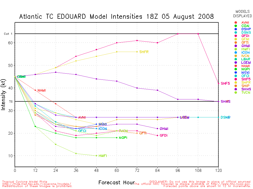
Update - Tuesday - 08/05, 7:00AM CT
Edouard makes landfall between high island and sabine pass as a tropical storm.
Update - Tuesday - 08/05, 6:51AM CT
Edouard looks like it will not make hurricane status before landfall, and adjustments overnight put the landfall point north of the Houston/Galveston area between there and Port Arthur.
The biggest story from Edouard will be the rainfall. Outside of Edouard, not much to look at except a wave off Africa.
Galveston Beach Cam Recording
Update - Monday - 08/04, 6:04PM CT
Edouard weakened a bit this morning to 45MPH, but from recon and radar it appears to have begun slowly reorganizing.
Right now it is still expected to make landfall at or near Galveston, TX tomorrow afternoon as a strong Tropical Storm and a small chance of a minimal hurricane. Follow local media, and official statements if you are in the area. Generally prepare for a category 1 hurricane, but expect a Tropical Storm.
Things that could change are if the storm slows down forward motion, giving it more time to organize, or if it manages to get on an organization spree or not. The former is possible, the latter is less likely.

Update - Monday - 08/04, 6:40AM CT
Edouard continues to move generally westward around 8MPH this morning. Tropical Storm Warnings still remain, and a Hurricane Watch is up from Port O'Connor Texas to west of Intracoastal City, Louisiana. There is a chance that Edouard could become a category 1 before landfall, and thus those in the warning area should prepare, especially boaters and those along the coast. Listen to local media and authorities for more information.
The most likely scenario (as of now, this could change) is that it makes landfall at or just north of Galveston as a strong Tropical Storm, not making it to hurricane strength. The rain potential is probably the largest worry about this one.

Update - Sunday - 08/03, 6PM ET
Based on latest RECON data, has upgraded TD#5 to Tropical Storm Edouard at 03/22Z. Sustained winds now at 45mph and central pressure down to 1002MB. Tropical Storm Watches and Warnings remain unchanged, however, winds prior to landfall on Tuesday afternoon have been increased to 65mph gusting to 80mph. If the increase in windspeed materializes, this would make Edouard a potent Tropical Storm. Folks in the north Texas and Louisiana coastal areas need to stay current on the movement and intensity of this storm and begin initial storm preparations at this time.
ED
Original Post - Sunday 08/03, 5PM ET
Invest 91L in the gulf has become a Tropical Depression this afternoon, and because of its proximity to the north central Gulf coast, Tropical Storm warnings are now up in Louisiana from the mouth of the Mississippi river westward to Intracoastal City, and Tropical Storm watches are up west of there to Port O'Connor Texas.

Mid to upper level winds indicate a movement toward the north Texas coastal area. Moderate easterly windshear is likely to inhibit any significant development but folks in the north Texas to western Louisiana coastal areas should monitor this TD closely since there is a possibility that the windshear will relax. The initial forecast brings TD#5 to Tropical Storm strength within 24 hours. The next name on the list is Edouard.
The latest model run brings TD#5 to hurricane strength, but right now that remains unlikely. However, it does mean that people in the watch/warning areas will want to keep a close watch on this system.
What do you think TD#5 will do, where will it go? How strong? Let us know in the TD#5 Lounge .
Event Related Links:
Level 3 Radar Recording of Edouard from HCW
Regional Composite Radar (Edouard)
|
cieldumort
Moderator

Reged:
Posts: 2305
Loc: Austin, Tx
|
|
We just got a new vort fix. Extrapolated, pressure is now down around 1002 mb, with max. flight-level winds at 53 knots. Considering the less-than ideal environment Five is currently in, this does not bode well should it find itself in something closer to an ideal environment at any time between now and the nearly certain northwestern GOM landfall this week.
Given the fairly rapid deepening this afternoon, and somewhat improved convective organization, higher percentages of these much stronger flight level winds may begin transporting down to the surface at any time.
|
Random Chaos
Weather Analyst

Reged:
Posts: 1024
Loc: Maryland
|
|
Officially Tropical Storm Edouard, per 6pm special update.
(As noted on the Update to this thread in the leadoff article.)
Edited by Ed Dunham (Sun Aug 03 2008 10:23 PM)
|
danielw
Moderator

Reged:
Posts: 3525
Loc: Hattiesburg,MS (31.3N 89.3W)
|
|
I too am a bit concerned at the 5mb drop in 90 minutes time.
The wind speed increase this afternoon is also a bit nerve wracking with regard to Edouard's proximity to land. We've learned that rapid spin up is a possibility with any developing system in the GOM over the last two years.
Humberto 2007 and Dolly 2008 both surprised thousands, if not millions of people with the rapid spin up scenario.
221800 2813N 08755W 9843 00198 0072 +206 +200 138050 052 999 999 03
210700 2805N 08749W 9665 00353 0069 +186 +186 158052 054 999 999 03
These are raw HDOB observation with the peak flight level winds speeds. Both of the observations are in the same area.
Near 28.05 to 28.13N/ 87.49 to 87.55W
I haven't looked at much of the surface data but this would seem to indicate the NE Quadrant of the Storm. Referencing the coordinates. It does appear that this is the NE Quadrant that the highest wind speeds are being detected.
71 minutes apart, so the next set should be transmitted around 2329Z or 729PM EDT.
|
Beaumont, TX
Storm Tracker
Reged:
Posts: 318
|
|
Our local met said Ed is supposed to pick up speed (hope that is the case). Should be tropical storm at landfall but a hurricane is a possibility. Right now
looks like landfall around Galveson. All happening pretty quick. Glad they got the warnings and watches up.
It will take some people a day or two to pay attention.
Our met did say we have the possibility of a lot of rain.
|
Storm Hunter
Veteran Storm Chaser

Reged:
Posts: 1370
Loc: Panama City Beach, Fl.
|
|
the latest vortex report.. pressure up 1mb to 1003mb... but i was interested in the HDOB and SFMR data...
A. Time of Center Fix: 3rd day of the month at 22:22:10Z
B. Center Fix Coordinates: 28°04'N 88°04'W (28.07N 88.07W)
D. Estimated (by SFMR or visually) Maximum Surface Wind: 55kts (~ 63.3mph)
Maximum Flight Level Wind: 53kts (~ 61.0mph) in the northeast quadrant at 22:18:10Z
Maximum Flight Level Wind Outbound: 35kts (~ 40.3mph) in the southwest quadrant at 22:23Z
Sea Level Pressure Extrapolation From: 1,500 feet
Appears that the strongest winds are on the NE side... and are pretty strong right now. Looks to me the center is almost exposed on the west and northwest side... ???
--------------------
www.Stormhunter7.com ***see my flight into Hurricane Ike ***
Wx Data: KFLPANAM23 / CW8771
2012== 23/10/9/5 sys/strms/hurr/majh
Edited by Storm Hunter (Sun Aug 03 2008 11:05 PM)
|
danielw
Moderator
Reged:
Posts: 3525
Loc: Hattiesburg,MS (31.3N 89.3W)
|
|
That VORTEX message would indicate that the Flight Level Winds are mixing all the way down to the surface!! That's is not a Normal Observation.
Surface winds are normally estimated to be 90% of the 700mb or 10000ft Flight Level Wind.
Strange Storm. That surface wind... if it's correct, is just 10 mph or so, shy of Hurricane Force winds.
|
Hugh
Senior Storm Chaser
Reged:
Posts: 1060
Loc: Okaloosa County, Florida
|
|
What's the shear like near the storm? It looks on the satellite like there's some moderate to storm shear, which would prevent strengthening - yet the vortex messages indicate storm winds.
Remember proper Forum posting and using the PM feature for questions.
--------------------
Hugh
Eloise (1975) - Elena and several other near misses (1985) - Erin & Opal (1995) - Ivan (2004)
Edited by Storm Cooper (Mon Aug 04 2008 12:13 AM)
|
Storm Cooper
User
Reged:
Posts: 1290
Loc: Panama City , FL
|
|
This is a re-post from the last Thread... read it!
Two items to take note of:
1) 'bets', 'hunches' and model projection posts belong in the Forecast Lounge.
2) In the last few days there has been quite a few one-line posts. Just a reminder that is not a chat room and that these types of posts are likely to be deleted or sent to the Graveyard. Your help on this is solicited.
ED
--------------------
Hurricane Season 2017 13/7/1
|
Old Sailor
Storm Tracker

Reged:
Posts: 293
Loc: Florida
|
|
The only good thing about Edouard will only have a about 48 hrs to to rev up in the bath tub known as the GOM. just hope it doesn't slow down...
|
Storm Hunter
Veteran Storm Chaser
Reged:
Posts: 1370
Loc: Panama City Beach, Fl.
|
|
Quote:
Surface winds are normally estimated to be 90% of the 700mb or 10000ft Flight Level Wind.
they should have been lower then the normal 700mb flight level... matter of fact they were flying at about 168 meters (~ 551 feet) durning that part of the leg... went back to find where the max flight level wind was at... i could only find the 18:30 after one... not the "Maximum Flight Level Wind: 53kts (~ 61.0mph) in the northeast quadrant at 22:18:10Z"... so i'm not sure what the reduction rate is on that... i see they bumped the 8pm adv. up to 50mph... WoW.. from a Low to TD to TS all less than 16 hrs... crazy
Time: 22:18:30Z
Coordinates: 28.20N 87.95W
Acft. Static Air Press: 984.1 mb (~ 29.06 inHg)
Acft. Geopotential Hgt: 197 meters (~ 646 feet)
Extrap. SFC. Press: 1007.0 mb (~ 29.74 inHg)
D-value: -
Flt. Lvl. Wind (30s): From 133° at 46 knots (From the SE at ~ 52.9 mph)
Air Temp: 20.3°C (~ 68.5°F)
Dew Pt: 20.0°C (~ 68.0°F)
Peak (10s) Flt. Lvl. Wind: 49 knots (~ 56.3 mph)
SFMR Peak (10s) SFC. Wind: -
SFMR Rain Rate: -
Edited by Storm Hunter (Mon Aug 04 2008 01:28 AM)
|
danielw
Moderator
Reged:
Posts: 3525
Loc: Hattiesburg,MS (31.3N 89.3W)
|
|
I failed to look at the aircraft altittude. Shame on me. The surface winds at the 1500 foot level would be fairly close to the 1500ft level winds. I'll have to look up the correction and see what they use.
Judging from the latest Advisory it must be close to 95% of Flight Level Winds at 1500ft.
http://www.nhc.noaa.gov/aboutwindprofile.shtml#fig1
The strongest winds in the eyewall are found near 500 m (1600 ft) elevation; these are about 20% higher than the 700 mb wind, owing to the warm-core nature of the tropical cyclone.
note: this refers to the Eyewall winds.~danielw
Edited by danielw (Mon Aug 04 2008 02:36 AM)
|
billyinpcb
Unregistered
|
|
what are the chances of this hitting the panama city area, becuase one slight turn, and florida could be in a bad perdicument, for isntance, if it takes a dip south, and restrengthens, and comes back north towards panama city, we could be in a bad situation, right? 
|
LoisCane
Veteran Storm Chaser

Reged:
Posts: 1236
Loc: South Florida
|
|
Edouard looks weak and shows badly on satellite imagery. There is an exciting pulse of convection but it is not where the storm is supposed to be. Run this loop and click on the points and you will see it is far to the south.
http://www.ssd.noaa.gov/goes/flt/t2/sloop-avn.html
On the other hand if the storm reformed under this ball of convection we could have a whole new ball game. A stronger storm, more put together and that would allow for some real intensification. Note I carefully said "real" not "rapid" as there is a rush to use that word these days.
It is a Tropical Storm but looks more like a depression turning into a storm to my eyes. Still coming together.
11pm discussion was not that conclusive as to the end game.
If Edouard was as neatly wound as that Atlantic Wave (99) then I would worry more on how high he could ramp up.
Storms forming in the Gulf close in have to be watched carefully and can the situation can change fast. There is no real time to prepare unless it stalls. has it moving slowly west and hopefully that will help move it along. As a lot of Gulf Coast cities will be to it's north there is a chance that many areas can get a lot of weather.
This is a tropical Storm still and we need not to look at an "eye" like path or point but a whole area of weather that may develop into something stronger but for now it is a Tropical Storm, barely and still pulling itself together.
--------------------
http://hurricaneharbor.blogspot.com/
|
Storm Hunter
Veteran Storm Chaser
Reged:
Posts: 1370
Loc: Panama City Beach, Fl.
|
|
looks like to me Edouard took a beating this evening.... the center looks to have MOVED WAY to the west? (A BIG JUMP???) it was moving at 5mph in the 11pm adv. but looking at the sats... i think it gone more than 25 miles this evening?
Shortwave
Recon is about to the "center area" and we should no soon.... it almost looks like the low spunn its self up and then shot to the west some? north of all the deep convection. Clearly the center looks exposed on sats.
UPDATE: Based on recon data comin in... looks to me the center went about 85miles to the wsw of the 00Z position? near 28.03N 89.57W with pressure of 1006mb? will see in a little bit
--------------------
www.Stormhunter7.com ***see my flight into Hurricane Ike ***
Wx Data: KFLPANAM23 / CW8771
2012== 23/10/9/5 sys/strms/hurr/majh
Edited by Storm Hunter (Mon Aug 04 2008 06:00 AM)
|
SueB
Unregistered
|
|
Call me crazy but we have a probable tropical storm which could become a catagory 1 hurricane....and there are no comments? By this time in the past....there would be lots of folks following the progression. I am a lurker since '04 and have learned much from the experts and quasi-experts on the site....where are you all now? 
|
rmbjoe1954
Weather Master

Reged:
Posts: 427
Loc: Port Saint Lucie, Florida, USA
|
|
Well IMHO I see warm cloud tops to the northwest of Edouard. This tells me it should not gaining much in strength..yet.
--------------------
________2023 Forecast: 20/10/5________
There is little chance that meteorologists can solve the mysteries of weather until they gain an understanding of the mutual attraction of rain and weekends. ~Arnot Sheppard
|
MikeC
Admin
Reged:
Posts: 4544
Loc: Orlando, FL
|
|
Quote:
Call me crazy but we have a probable tropical storm which could become a catagory 1 hurricane....and there are no comments? By this time in the past....there would be lots of folks following the progression. I am a lurker since '04 and have learned much from the experts and quasi-experts on the site....where are you all now?
Edouard isn't going to do much, it's chances for becoming a hurricane are running out very quickly, it'll likely bring some rain and a bit of wind. The catch is (from newer visible satellite photos) it may be trying to organize again, so I still think people should prepare for a category 1.
When things like that (it seems Texas is not a big a draw as the east coast for reasons I really don't understand either) things are quiet. After 2004 and 2005 went into a permanent lockdown.
EditI moved further site discussion over here
|
Beaumont, TX
Storm Tracker
Reged:
Posts: 318
|
|
No, Texas does not seem to be as big of a draw. Ed looks so tiny out there in the big old Gulf. He's spinning...he's trying...but just won't have the time
or the perfect conditions. We should get rain, maybe some wind here on the upper Texas coast if he makes landfall in Galveston.
|
danielw
Moderator
Reged:
Posts: 3525
Loc: Hattiesburg,MS (31.3N 89.3W)
|
|
Using the visible satellite from 1818Z, see attachment.
Edouard has completed about 80% of a complete wraparound. It appears that dry air entrainment is one of the reasons for the incomplete wrap. Notice the lack, or near absence of cloud and cloud streets in the band between the date and time. (The band of blue that wraps into the west side of Edouard). This wraps into the Western Semicircle of Edouard between the SW and W Quadrants.
Remainder of the GOM is NOW beginning to contribute to Edouard's inflow.
Cloud streets are noted as far south as the Bay of Campeche', and the Yucatan Peninsula. On the eastern side it appears that inflow from the Tampa/ Jacksonville area is also beginning.
To the NE of Edouard over extreme SE MS and SW AL there are large cumulus buildups with heavy rain in them. This outer band has been trying to intensify since 10 AM EDT this morning. I noticed a strange anomaly in the visible satellite and radar photos earlier. Close examination of the outer bands would show that the two arcing bands, over LA and MS, don't line up, Band currently over AL and MS would be centered a bit further east than the band currently over LA. Edouard may have a slight internal tilt. Somewhat like a tilted tornado or waterspout.
Something tells me Edouard has a few more surprises in his Vortex. Might need to keep an eye on this one!
|


 Threaded


