F
Current Radar or Satellite Image

Flhurricane.com - Central Florida Hurricane Center - Tracking Storms since 1995Hurricanes Without the Hype! Since 1995


Special Tropical Weather Outlook issued for area in the East-Central Atlantic, only with 10% chance for development, not expected to do much.
Days since last H. Landfall - US: Any 238 (Idalia) , Major: 238 (Idalia) Florida - Any: 238 (Idalia) Major: 238 (Idalia)


Archives 2010s >> 2019 News Talkbacks

Pages: 1
cieldumort
Moderator


Reged:
Posts: 2305
Loc: Austin, Tx
Back Half of the Season Kicking off With Multiple Systems
      #100700 - Tue Sep 17 2019 12:00 AM


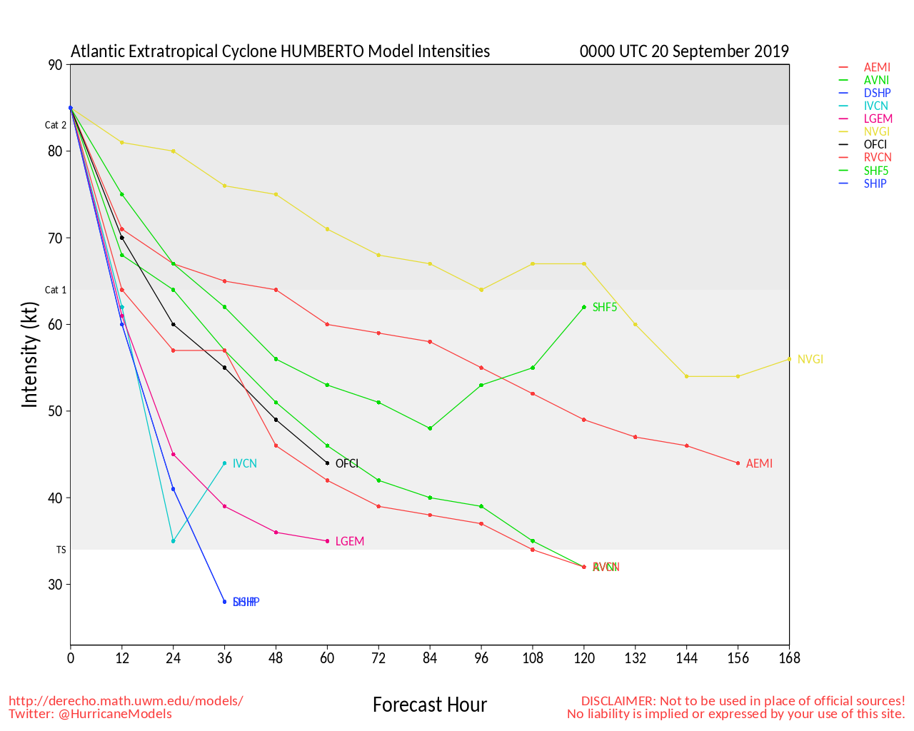
Conditions for development across the Atlantic are entering a new phase, with several systems worth watching, not the least of which is powerful Hurricane Humberto, now expected to become a Major within the next 36 hours and potentially directly impact Bermuda.
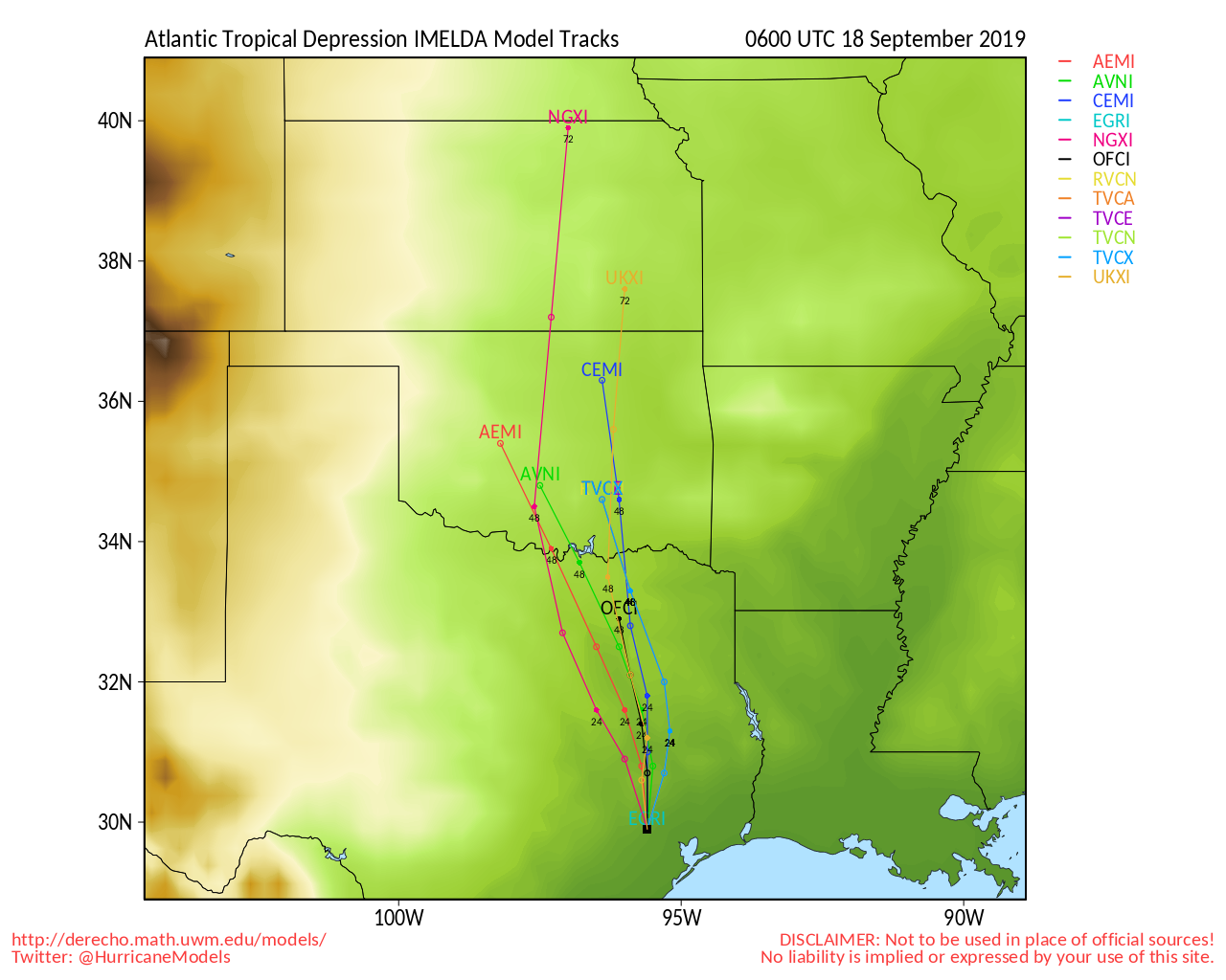
Much closer to the CONUS, an area of disturbed weather in the western Gulf of Mexico has strong model support to produce a deluge in eastern Texas whether or not it ever gets a name. This system is potentially a particularly dangerous situation unfolding, and just because it does not already have a name (and may never get one) is no reason not to prepare for something akin to a very slow moving Tropical Storm, with training bands of showers and thunderstorms setting up over some of the same areas - exact locations which as of yet are still unknown, but could even include parts of the very flood-prone Houston metro.

In the eastern Caribbean we are still keeping an eye out on Invest 96L, which is being held in check from high shear. However, behind 96L we are laser focused on 97L, with now 90% NHC odds of development, and a track that at this point is just too close to call for the Antilles.

As always, feel free to follow along with us in the Forecast Lounge, where we dive into a good deal of model talk.
Current active Lounges include:
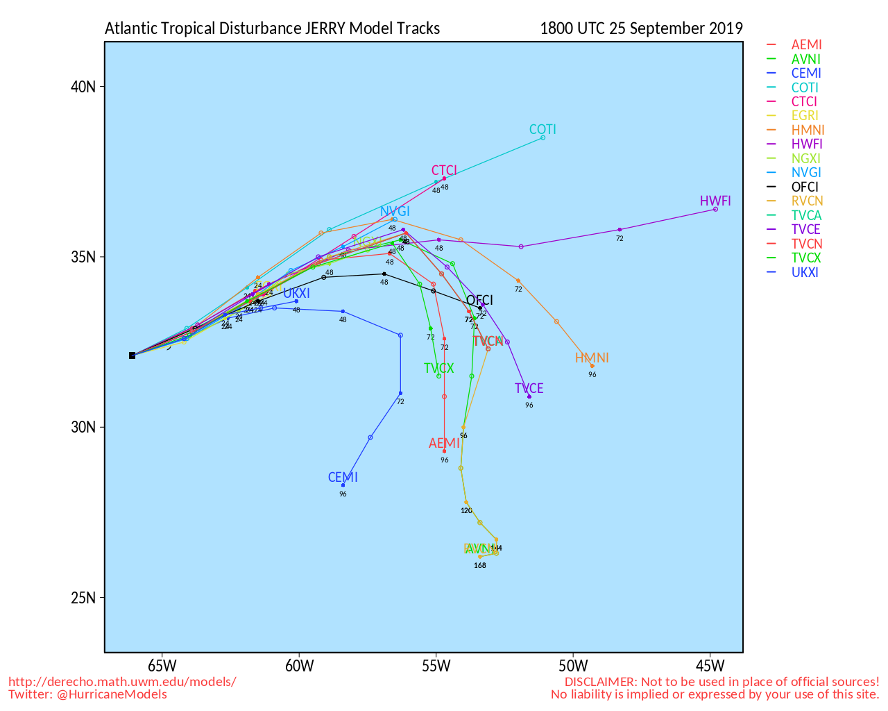
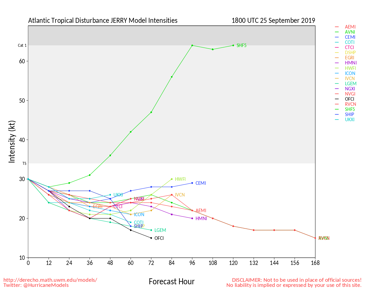
Humberto Lounge , Invest 96L Lounge , Jerry Lounge, Imelda Lounge , Invest 99L Lounge

Harris County Flood Warning System


Texas Gulf Coast Links [http://moe.met.fsu.edu/~mnissenbaum/radar.html Mark Nissenbaum's radar page} East to West:

<html> <a href="https://radar.weather.gov/ridge/lite/K</html>HGX<html>_loop.gif" onMouseover="ddrivetip('<img src=\'https://radar.weather.gov/ridge/lite/K</html>HGX<html>_loop.gif\'>');" onMouseout="hideddrivetip();"></html>Houston/Galveston, TX Radar<html> Radar Loop</A>

(<a href="https://radar.weather.gov/ridge/lite/K</html>HGX<html>_0.gif" onMouseover="ddrivetip('<img src=\'https://radar.weather.gov/ridge/lite/K</html>HGX<html>_0.gif\'>');" onMouseout="hideddrivetip();">Latest Static</a>)</html>

<html> <a href="https://radar.weather.gov/ridge/lite/K</html>CRP<html>_loop.gif" onMouseover="ddrivetip('<img src=\'https://radar.weather.gov/ridge/lite/K</html>CRP<html>_loop.gif\'>');" onMouseout="hideddrivetip();"></html>Corpus Christi, TX Radar<html> Radar Loop</A>

(<a href="https://radar.weather.gov/ridge/lite/K</html>CRP<html>_0.gif" onMouseover="ddrivetip('<img src=\'https://radar.weather.gov/ridge/lite/K</html>CRP<html>_0.gif\'>');" onMouseout="hideddrivetip();">Latest Static</a>)</html>

<html> <a href="https://radar.weather.gov/ridge/lite/K</html>BRO<html>_loop.gif" onMouseover="ddrivetip('<img src=\'https://radar.weather.gov/ridge/lite/K</html>BRO<html>_loop.gif\'>');" onMouseout="hideddrivetip();"></html>Brownsville, TX Radar<html> Radar Loop</A>

(<a href="https://radar.weather.gov/ridge/lite/K</html>BRO<html>_0.gif" onMouseover="ddrivetip('<img src=\'https://radar.weather.gov/ridge/lite/K</html>BRO<html>_0.gif\'>');" onMouseout="hideddrivetip();">Latest Static</a>)</html>

Gulf of Mexico Satellite Imagery

Area Forecast Discussions: Houston/Galveston, TX - Corpus Christi, TX - Browsnville/South Padre Island, TX


j


East Florida Links <html><a href="http://radar.weather.gov/ridge/Conus/southeast_lite_loop.php" onMouseover="ddrivetip('<img src=\'http://radar.weather.gov/ridge/Conus/Loop/southeast_loop.gif\'>');" onMouseout="hideddrivetip();">Southeast Composite Radar Loop</A>

(<a href="http://radar.weather.gov/ridge/Conus/southeast_lite.php" 

onMouseover="ddrivetip('<img src=\'http://radar.weather.gov/ridge/Conus/RadarImg/southeast.gif\>');" onMouseout="hideddrivetip();">Latest Static</a></html>) South to North:

<html> <a href="https://radar.weather.gov/ridge/lite/K</html>BYW<html>_loop.gif" onMouseover="ddrivetip('<img src=\'https://radar.weather.gov/ridge/lite/K</html>BYW<html>_loop.gif\'>');" onMouseout="hideddrivetip();"></html>Key West, FL Radar<html> Radar Loop</A>

(<a href="https://radar.weather.gov/ridge/lite/K</html>BYW<html>_0.gif" onMouseover="ddrivetip('<img src=\'https://radar.weather.gov/ridge/lite/K</html>BYW<html>_0.gif\'>');" onMouseout="hideddrivetip();">Latest Static</a>)</html>

<html> <a href="https://radar.weather.gov/ridge/lite/K</html>AMX<html>_loop.gif" onMouseover="ddrivetip('<img src=\'https://radar.weather.gov/ridge/lite/K</html>AMX<html>_loop.gif\'>');" onMouseout="hideddrivetip();"></html>Miami, FL Radar<html> Radar Loop</A>

(<a href="https://radar.weather.gov/ridge/lite/K</html>AMX<html>_0.gif" onMouseover="ddrivetip('<img src=\'https://radar.weather.gov/ridge/lite/K</html>AMX<html>_0.gif\'>');" onMouseout="hideddrivetip();">Latest Static</a>)</html>

<html> <a href="https://radar.weather.gov/ridge/lite/K</html>MLB<html>_loop.gif" onMouseover="ddrivetip('<img src=\'https://radar.weather.gov/ridge/lite/K</html>MLB<html>_loop.gif\'>');" onMouseout="hideddrivetip();"></html>Melbourne, FL Radar<html> Radar Loop</A>

(<a href="https://radar.weather.gov/ridge/lite/K</html>MLB<html>_0.gif" onMouseover="ddrivetip('<img src=\'https://radar.weather.gov/ridge/lite/K</html>MLB<html>_0.gif\'>');" onMouseout="hideddrivetip();">Latest Static</a>)</html>

<html> <a href="https://radar.weather.gov/ridge/lite/K</html>JAX<html>_loop.gif" onMouseover="ddrivetip('<img src=\'https://radar.weather.gov/ridge/lite/K</html>JAX<html>_loop.gif\'>');" onMouseout="hideddrivetip();"></html>Jacksonville, FL Radar<html> Radar Loop</A>

(<a href="https://radar.weather.gov/ridge/lite/K</html>JAX<html>_0.gif" onMouseover="ddrivetip('<img src=\'https://radar.weather.gov/ridge/lite/K</html>JAX<html>_0.gif\'>');" onMouseout="hideddrivetip();">Latest Static</a>)</html>


Caribbean/South East Coast Satellite Imagery


SFWMD Radar Loop of South Florida with storm Track


SFWMD Full Florida Radar Loop with Storm Track


Area Forecast Discussions: FLorida Keys - Miami/South Florida - Melbourne/East Central Florida - Jacksonville/Northeast Florida -


Edited by MikeC (Sun Sep 22 2019 02:45 PM)


Post Extras: Print Post   Remind Me!   Notify Moderator  
Pages: 1


Extra information
0 registered and 0 anonymous users are browsing this forum.

Moderator:  

Print Topic

Forum Permissions
      You cannot start new topics
      You cannot reply to topics
      HTML is disabled
      UBBCode is enabled

Rating:
Topic views: 6499

Rate this topic

Jump to

Note: This is NOT an official page. It is run by weather hobbyists and should not be used as a replacement for official sources. 
CFHC's main servers are currently located at
Hostdime.com in Orlando, FL.
Image Server Network thanks to Mike Potts and Amazon Web Services. If you have static file hosting space that allows dns aliasing contact us to help out! Some Maps Provided by:
Great thanks to all who donated and everyone who uses the site as well. Site designed for 800x600+ resolution
When in doubt, take the word of the National Hurricane Center