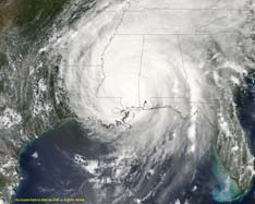
Hurricane Fredrick 1979
Weather Guru

Reged:
Posts: 116
Loc: Mobile,Alabama
|
|
Quote:
That's usually a good sign when Cantore is in your backyard. It's not going to hit there !! LOL
Was that you jumping up and down and waving hands behind the scenes?
TWC has put Mike Slidell here in Mobile and I said where he is there is where it usually gonna hit. But God knows we dont need another nor Frederick
|
Margie
Senior Storm Chaser

Reged:
Posts: 1191
Loc: Twin Cities
|
|
Quote:
Yeah, no kidding ! I noticed that on the models, too ! I wonder if they'll move the predictions over in response ?? God, I don't know what I hate worse...... this waiting, or the actual storm !! Neither one is much fun !
I don't think so, because the holdout for a FL landfall is the model...however yesterday Gulfport and Biloxi did not have any significant strike probabilities to speak of, and today they do.
--------------------
Katrina's Surge: http://www.wunderground.com/hurricane/Katrinas_surge_contents.asp
|
Terra
Storm Tracker
Reged:
Posts: 286
Loc: Kingwood, Texas
|
|
Remember, strike probabilities are just that you are within 65 nautical miles from where the storm passes.... as the storm gets closer to making landfall, strike probabilities increase for places where landfall is not expected as well.
--------------------
Terra Dassau Cahill
|
danielw
Moderator

Reged:
Posts: 3525
Loc: Hattiesburg,MS (31.3N 89.3W)
|
|
As of 9 AM this morning. The Misssissippi MDOT, has staged part of the Contraflow for New Orleans traffic.
This is a preliminary stage only.
Signs are set in place to route northbound Interstate 59 as four lanes from the Louisiana State Line to US Hwy 98 just south of Hattiesburg,MS.
When the next stage is reached NO Southbound traffic, on I-59, will be allowed South of Hattiesburg,MS at the US Hwy 98 interchange.
This has never been done before, so it may have a few kinks in it.
US 98 traffic from the AL/ FL area will be routed around Hattiesburg on I-59.
US Hwy 49 traffic from the MS Gulf Coast will be routed thru Hattiesburg toward Jackson.
Very few on and off points are planned. For traffic control purposes.
post copied to the Disaster Forum
|
MichaelA
Weather Analyst

Reged:
Posts: 944
Loc: Pinellas Park, FL
|
|
Quote:
The eye is now visible on long range radar out of Tampa.
Been toggling between Tampa Bay and Key West radars. Great representations. Looks like the eye has closed now.
--------------------
Michael
PWS
|
Rick on boat in Mobile
Weather Drama Guru

Reged:
Posts: 161
|
|
its going more west...than thought...gotta go..more later
|
HanKFranK
User

Reged:
Posts: 1841
Loc: Graniteville, SC
|
|
adogg, history or no, there is a ridge axis over florida that is orienting nnw-sse up towards the ohio valley, and a mid-upper trough over the western gulf. the hurricane should move between them. forecast models have been clustered from the panhandle over to the mouth of the mississippi for days, and all of that evidence is the best thing we have to go on. you really ought to tone down the central florida mongering... at least the south florida mongerging has ended.
as far as the probs going higher on the central gulf, margie.. that's because the hurricane is closer. those forecast probs are a function of where the official track is and how many days away the storm is... it's closer now, so higher confidence even though the forecast has only shifted back to the left a little. the forecast track hasn't deviated much for four days now.
HF 1535z09july
Edited by HanKFranK (Sat Jul 09 2005 02:37 PM)
|
mbfly
Weather Guru

Reged:
Posts: 119
Loc: Mobile, Alabama
|
|
Quote:
sorry ya'll...more of a gut feel
I sure as heck hope you're wrong !!!!! 
|
HanKFranK
User

Reged:
Posts: 1841
Loc: Graniteville, SC
|
|
well rick, there are about a dozen other 'gut feels' floating around. what makes yours better?
i'll take solid reasoning any day over auguries and wishcasting.
HF 1539z09july
|
pcola
Storm Tracker

Reged:
Posts: 344
Loc: pensacola/gulf breeze
|
|
I think everyone between Ft Walton and Mobile can expect hurricane force winds. Latest Adv. still at 100mph, but with 30 hours to go, and the peak convection times tonight, a fear it getting back to 3 status.
--------------------
Erin 95 , Opal 95, Ivan 04, Dennis 05, and that's enough!!!!
|
Daytonaman
Weather Watcher

Reged:
Posts: 28
Loc: Port Orange, FL
|
|
Hank, is the ridge on FLEC the reason that the rain bands coming up from the SE on the Melbourne Radar seem to just dry up and die before they reach points north of Melbourne?
--------------------
Bruce
Port Orange, FL
29.14 80.99
Thanks to all who work so hard to teach those of us without the knowledge but the thirst to know.
|
TDW
Weather Watcher
Reged:
Posts: 37
Loc: Mobile, AL
|
|
Hattiesburg traffic was a nightmare during - I59 and Hwy98 meeting in a bottleneck. I went through there, luckily I knew the back country roads. A lady from Foley told me it took her 11 hours to get to Hwy 49 north of Hattiesburg (rom Foley - normally about 2-1/2 hours).
Let's hope this time it is better. I would hate to see a bunch of people trapped on the Hwy at the height of the storm.
--------------------
"It's time to see the world
It's time to kiss a girl
It's time to cross the wild meridian"
|
MikeC
Admin
Reged:
Posts: 4544
Loc: Orlando, FL
|
|
Anyone find this useful?
I'm polishing it up a bit more but it works and is auto updated with tracks
http://flhurricane.com/googlemap.php?2005s4-2004s9-2004s3
|
Terra
Storm Tracker
Reged:
Posts: 286
Loc: Kingwood, Texas
|
|
Quote:
This has never been done before, so it may have a few kinks in it.
Have you seen the NO contraflow plan??? It's the most insanely designed thing I have ever seen... A few kinks? I think we'll need to call it Contra-slow if we ever try using it. There is absolutely no flexibility on where you get to go...
--------------------
Terra Dassau Cahill
|
turkeyman
Registered User
Reged:
Posts: 8
Loc: Picayune, MS
|
|
Hank Frank, you're right! I've been patiently reading all the posts over the last three days and even saved to disk, the projected path by the , 4 days ago. Their prediction seems to be coming to fruition. Now the storm threat has passed the Southern sector of Florida, most of those posters have gone elsewhere.
|
Ron Basso
Storm Tracker

Reged:
Posts: 267
Loc: hernando beach, FL
|
|
Quote:
its going more west...than thought...gotta go..more later
Maybe...we'll know in 36 hours (or later?)...I dunno..I've been looking at ' motion the last 2 hours & he is not moving at 14 mph to the NW..if anything a slow drift to the west..he seems to be in search of some steering currents & is wobbling around..perhaps he's doing an eyewall replacement...whatever, this is bad news for the lower keys. While escaping major hurricane force winds, Key West has now had sustained winds over 40 mph with gusts in the 60-70 mph range for well over 12 hrs...storm tides are now up to 5 feet near the airport.
--------------------
RJB
|
GuppieGrouper
Weather Master
Reged:
Posts: 596
Loc: Polk County, Florida
|
|
The sun has been out briefly here in Central Florida. It feels like a normal summer day. The radar is showing a nice picturesque hurricane going away from the Western side of the Florida peninsula. I am going to watch what happens to our weather but feel sure that the worst is over for the central Florida area. That is my gut feeling on this one. Summer thunderstorms are no problem and the wind is not high so an umbrella can take care of that. over and out.
--------------------
God commands. Laymen guess. Scientists record.
|
Daytonaman
Weather Watcher

Reged:
Posts: 28
Loc: Port Orange, FL
|
|
I really like this but if I had to suggest a change, I would like to only see the balloon points when the storm changes catagories ie from TS to H1. Would be a little less cluttered and probably better able to see the actual track of each storm. Otherwise really great.
--------------------
Bruce
Port Orange, FL
29.14 80.99
Thanks to all who work so hard to teach those of us without the knowledge but the thirst to know.
|
EMS
Weather Hobbyist
Reged:
Posts: 55
Loc: St. Petersburg, Florida
|
|
Amen. I rarely post but am continuously online reading the wonderful information and ideas that are exchanged here. However, it's one thing to post a view that ends up being wrong (heck, since when are meterologists right? :>), but I deplore folks like adogg who are clearly making stuff up just to scare people.
My best wishes to those on the northern Gulf coast who will be impacted by (another) dangerous hurricane.
|
LadyStorm
Weather Guru

Reged:
Posts: 154
Loc: United States
|
|
Quote:
Anyone find this useful?
I'm polishing it up a bit more but it works and is auto updated with tracks
http://flhurricane.com/googlemap.php?2005s4-2004s9-2004s3
Awesome map, thanks Mike!!!
--------------------
"The significant problems we face cannot be solved at the same level of
thinking we were at when we created them"
..........Albert Einstein
|


 Threaded


