Rabbit
Weather Master

Reged:
Posts: 511
Loc: Central Florida
|
|
TD11 radar
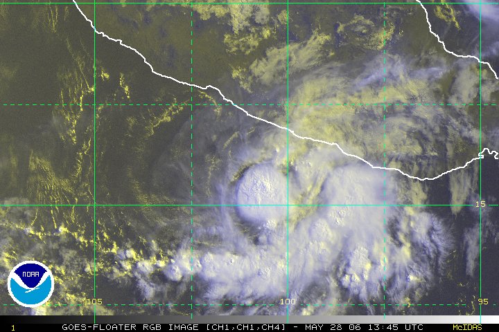
the center is easily descernable and it is likely that this is near TS intensity now
has the plane been in it yet?
|
scottsvb
Weather Master
Reged:
Posts: 1184
Loc: fl
|
|
Quick post here. Well I may not be very good at forecasting strength of a system, Im pretty damn accurate looking at where a system will go. My BOC system should be a TS and move inland late tonight into tomorrow. Its gone on forecasted track,although I thought it could of been more N, but the upper low to its w pulled it more towards it.
Old TD10 or so called I should say should develop more into a TD over the next day or so. Movement will be wnw then NW. I place it near Nassau ( somewhere) by weds night. Then as the trough exits out and ridging builds over the SE, expect a crossover of S florida from the Keys-Melbourne by Friday. As it gets into the SE gulf the steering flow will be weak as the ridge slides N of the bahamas and a weak trough moves into the SE US late this weekend into early next week.
Overall movement will continue to be slow. Strength? Ill leave that to people who forcast those better.
scottsvb
|
native
Weather Guru

Reged:
Posts: 148
Loc: SE Florida
|
|
Hey all...check out this VIS SAT. Awesome view.
Clearly visable is TD 11 BOC storm, XTD10 is definitely showing more TD characteristics.
But of interest....look at how impressive 97L looks from this angle even in its current condition.
www.sfwmd.gov/org/omd/ops/weather/zoomvis.jpg
|
ralphfl
Weather Master
Reged:
Posts: 435
|
|
i can't resist but i do remember you did have many comments on Emily going north.Each time it took a jog north you had it going over cuba and there was another you said was going somehwere i remember but then when it went elsewhere you dissapered from posting.
So not bashing you but like many others on here we all have been wrong on paths as well as how strong.
Edited by ralphfl (Mon Aug 22 2005 04:18 PM)
|
Rabbit
Weather Master

Reged:
Posts: 511
Loc: Central Florida
|
|
do you have a loop of this image anywhere? it would be interesting to see exactly how organized XTD10 is and if 97L is getting any better organized
|
native
Weather Guru

Reged:
Posts: 148
Loc: SE Florida
|
|
No (for 97L) , unfortunately that site only has that VIS SAT in still image.
Here is the site's SATs in their entireties. You can check out XTD10 on the E.CARB (obviously) loop..shows nicely.
www.sfwmd.gov/curre/3_satellite.html
|
Hawkeyewx
Weather Analyst
Reged:
Posts: 99
|
|
It already looks like we have Tropical Storm Jose in the BOC and it appears to be gaining strength fairly quickly. It looks a lot better than Gert ever did.
The Bahamas system looks interesting, with a southwesterly surface wind being pulled off the eastern section of Cuba. The upper low to its north should keep any development in check for the next day or two, but the upper air conditions should improve thereafter. This could be an interesting system if the planets align just right.
97 Invest is a HUGE circulation, but it is already pretty far to the north so it would have to stay pretty weak to make it across the Atlantic without turning north ahead of the trough off the US east coast.
|
native
Weather Guru

Reged:
Posts: 148
Loc: SE Florida
|
|
Quote:
97 Invest is a HUGE circulation, but it is already pretty far to the north so it would have to stay pretty weak to make it across the Atlantic without turning north ahead of the trough off the US east coast.
It looks like it has the potential to become a monster storm should it develope...let's hope it only spins fish.
|
Clark
Meteorologist
Reged:
Posts: 1710
Loc:
|
|
TD 11 is still a 30kt depression, but recon isn't out there yet. Kinda curious as to why the package came out to early if recon is supposed to be there for a fix by 5p as per the report (and was close at 4p), but oh well. Do expect a special advisory to bump this up to a TS -- Jose -- within the next hour or so. And no, unlike the initial 5p discussion said, this won't be storm #11 for the season...just #10. They'll correct that, too.
Low center might be trying to form on the NE end of the disturbed area in the Bahamas, due north of Hispaniola and due east of Homestead, FL, but it's not closed yet and winds are light in that area. It's got the potential for development, but it's not going anywhere fast over the next few days, giving us plenty of time to watch it. General track towards S. Florida over the next few days is likely; beyond that, too early to tell. Edit: check water vapor...definite upper-low is what is being reflected there. Gotta work it's way down to the surface -- not out of the question -- but it's going to impede anything else from getting going in its immediate vicinity in the near-term.
If nothing else, 97L has consolidated somewhat. The convection on the southern end is gone and new convection appears to be trying to fire near the low-level center near 17N/34W. Will have to watch the trends with that overnight, but if it holds together, it'll probably become a depression sometime tomorrow or Wednesday. Area just along the coast has impressive convection but not much organization yet...still one to watch over the coming days.
More later if I get a chance, though with TD 11/Jose about ready to move inland, there's not a whole lot to update...yet.
--------------------
Current Tropical Model Output Plots
(or view them on the main page for any active Atlantic storms!)
|
Clark
Meteorologist
Reged:
Posts: 1710
Loc:
|
|
No vortex report yet, but the first few recon reports near the system suggest it is a tropical storm. They are flying at very low levels -- between about 750 and 1000ft -- and have reported winds to 48kt on the SE side of the circulation. Pressure is being reported around 1003-1005mb. Winds along the north and east sides of the storm suggest a definite closed center...only a matter of time before we get a vortex report and an upgrade to Jose.
--------------------
Current Tropical Model Output Plots
(or view them on the main page for any active Atlantic storms!)
|
scottsvb
Weather Master
Reged:
Posts: 1184
Loc: fl
|
|
This is typical in a low-midlevel circulation that comes down to the surface. Most mid-latitude systems that come down to the surface generally get to TS status soon as the winds in the midlevel are already from 35-60kt......I expect maybe 50mph right now, give or take 5tkt
|
Clark
Meteorologist
Reged:
Posts: 1710
Loc:
|
|
NHC just put out the update -- TS Jose with winds of 45mph. Full updated package to come.
--------------------
Current Tropical Model Output Plots
(or view them on the main page for any active Atlantic storms!)
|
Bloodstar
Moderator

Reged:
Posts: 467
Loc: Tucson, AZ
|
|
Really, that says it all... the on again off again system is kinda back on again 
-Mark
--------------------
M. S. Earth and Atmospheric Sciences, Georgia Tech - May 2020
NOAA MADIS/HADS Programmer
U. Arizona PhD Student
|
Rich B
British Meteorologist
Reged:
Posts: 498
Loc: Gloucestershire, England, UK
|
|
Well Jose looks set to be a shortlived storm, likely going inland tonight and nearing dissipation by this time tomorrow. Still, yet another one for the record books!
As far as xTD10 goes, it certainly seems to be giving yet another attempt at a comeback, and has gotten a little better organised. If this trend continues we could see it reclassified later tomorrow.
97L. Well, this is a huge circulation, which actually may not be working quite in its favour. I think that it could take a little longer yet for the whole system to consolidate, which it seems to be trying to do. Probably have to wait a day or two for classification of this system too.
Certainly seems to be firing off again as we approach the peak period of the season. And there will be plenty more to come before the year is out!
--------------------
Rich B
SkyWarn UK
|
NONAME
Weather Guru

Reged:
Posts: 136
|
|
Since navy has the area in the Bahamas as 10LNONAME the is would most likely be reclassified as TD 10 not anything else just to clear that up to any one who wanted to know. Just for superstitious people this would be the 3 time 10 would be trying to make a comeback so you know what they say 3rd times a charm so I would say it would come back it looks better than ever since it was in the central Atlantic.
--------------------
I am a young Weather enthusiast and really want to get to college in a couple of years for meteorology.
Edited by NONAME (Mon Aug 22 2005 06:30 PM)
|
Rabbit
Weather Master

Reged:
Posts: 511
Loc: Central Florida
|
|
winds expected to reach 60mph before landfall; we broke the record now for earliest tenth storm of the season (by less than 24hours)--the earliest 11th was Karen and the earliest 12th was Luis, both in 1995, and both on August 28.
we may break both of those, seeing as today is only the 22nd--Katrina may form from former TD10, within 72 hours if it does, and either 97L or the system behind it could become Lee before six days time (Lenny was retired in 1999)
note: this is not wishcasting (although it would certainly be a bit interesting to see); i do honestly think that we will have at least one storm out by Africa, at least by the end of the month, and i also think it is becomming increasingly possible for XTD10 to redevelop. It has hung on for 8 days now, without being classified, and has gotten into a less hostile area.
it is also still quite likely to have a very active season (we have already had an average number for an entire year, and there has NEVER been a year with nothing developing in September). Last year, 7 storms developed after August, which would match Clark's prediction (i think his was 17)
anyone else's thoughts on 10L, 97L, and the system behind it forming into storms at any point?
Edit: I'd love to take credit for the 17 prediction, as that is looking pretty good from where we sit now, but that's all HF. I was down for 14. --Clark
Edited by Clark (Mon Aug 22 2005 07:10 PM)
|
NONAME
Weather Guru

Reged:
Posts: 136
|
|
Look right in the middle in the red of this IR image looks like a eye is trying to form can someone help me confirm this or tell me what it is.
http://www.ssd.noaa.gov/PS/TROP/DATA/RT/FLOAT/IR4/20.jpg
--------------------
I am a young Weather enthusiast and really want to get to college in a couple of years for meteorology.
Edited by NONAME (Mon Aug 22 2005 06:48 PM)
|
scottsvb
Weather Master
Reged:
Posts: 1184
Loc: fl
|
|
its nothing,,defidently not a eye though.
|
Rich B
British Meteorologist
Reged:
Posts: 498
Loc: Gloucestershire, England, UK
|
|
Looks to me like that little red areea on the IR could be the beginnigs of a ... of course, i could be way of base here, but given the reasonable quick development of this system, it is certainly possible.
--------------------
Rich B
SkyWarn UK
|
Big Kahuna
Weather Hobbyist

Reged:
Posts: 52
Loc: DeLand, Florida
|
|
Sorry to get off the subject but it just hit me....TS JOSE is going to hit land in MEXICO....... Go figure....  . The way things have been lately I guess anything can happen. Whats next? . The way things have been lately I guess anything can happen. Whats next?
|


 Threaded


 . The way things have been lately I guess anything can happen. Whats next?
