Rasvar
Weather Master

Reged:
Posts: 571
Loc: Tallahassee, Fl
|
|
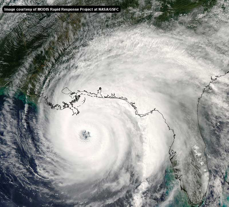
I find the lightning comment interesting. Lightining in the eyewall is pretty rare. If I recall correctly, usually only in very strong storms and ones that are getting stronger. That is from memory, so I may be completely off. Anyone care to correct me?
--------------------
Jim
|
hurricane expert
Really Not an Expert
Reged:
Posts: 105
Loc: florida
|
|
Could someone give me an image on water vaper where it shows the trough to the north.
|
Hugh
Senior Storm Chaser
Reged:
Posts: 1060
Loc: Okaloosa County, Florida
|
|
Lightning in the eyewall is something I have heard about before - but you're right, it's not common except in EXTREMELY powerful (cat 4/5) storms.
Something to consider: Last night at this point in time, where was forecast to be headed? Not where it currently is headed, I don't believe. Forecasts change - that's why they are forecasts. No one is safe!
--------------------
Hugh
Eloise (1975) - Elena and several other near misses (1985) - Erin & Opal (1995) - Ivan (2004)
|
Random Chaos
Weather Analyst

Reged:
Posts: 1024
Loc: Maryland
|
|
Good point. Doing some google searches on "lightning in eyewall" and I hit an interesting one:
http://www.usatoday.com/weather/resources/askjack/wahlight.htm
A quote in it from Peter Black who apparently used to (and may still) fly into hurricanes: "There was lightning reported in Camille's eyewall by the last Air Force recon crew that flew into it before landfall...."
Another discussion about lightning, including in eyewalls:
http://www.weatherwise.org/qr/qry.hurlit.html
Edited by Random Chaos (Sun Aug 28 2005 04:08 AM)
|
SirCane
Storm Tracker
Reged:
Posts: 249
Loc: Pensacola, FL
|
|
Here's a good water vapor image. You can see the trough digging down into Louisiana. Going to be interesting.
http://weather.unisys.com/satellite/sat_wv_east_loop-12.html
--------------------
Direct Hits:
Hurricane Erin (1995) 100 mph
Hurricane Opal (1995) 115 mph
Hurricane Ivan (2004) 130 mph
Hurricane Dennis (2005) 120 mph
http://www.hardcoreweather.com
|
Colleen A.
Moderator

Reged:
Posts: 1432
Loc: Florida
|
|
I honestly don't think that people from Florida WANT another storm here. I think what you are observing are possible scenarios that could effect PARTS of Florida. It is correct that at this time the current forecast track looks good, but as we all know hurricanes can and will deviate from current tracks. was supposed to hit near WPB; she ended up slamming Miami and the Keys, and I believe there was only one model that had that scenario. So there is some reasoning behind people saying it could shift more eastward. As of yet, that has not happened, it may not happen, but it COULD happen. Unfortunately, many of us have learned the hard way that hurricane forecasting is not an exact science and that they are very fickle. Those of us in Florida do not want anyone to go through what we've been through, nor do we want to go through it again ourselves.
Time will eventually tell the story of what exactly will happen with . 
--------------------
You know you're a hurricane freak when you wake up in the morning and hit "REFRESH" on CFHC instead of the Snooze Button.
|
Disaster Master
Weather Hobbyist

Reged:
Posts: 72
Loc: San Antonio G0! Spurs Go!
|
|
Can anyone come up with lightning data. Images or anything? :?:
-- here is one link:
http://www.flamedia.com/lightning/light.htm
Edited by RedingtonBeachGuy (Sun Aug 28 2005 04:12 AM)
|
ralphfl
Weather Master
Reged:
Posts: 435
|
|
Lightning in the eyewall is something I have heard about before - but you're right, it's not common except in EXTREMELY powerful (cat 4/5) storms.
Something to consider: Last night at this point in time, where was forecast to be headed? Not where it currently is headed, I don't believe. Forecasts change - that's why they are forecasts. No one is safe!
Actully it was forcasted about the same spot this time last night  i have no problem with your opinion just like me i dont think it will make it to NO but as with you just IMO and also i think the winds will get sheared before landfall just my feeling.What got us was your remark of "more likely" will go to Florida panhandle.I think that was the part that got a few people is All. i have no problem with your opinion just like me i dont think it will make it to NO but as with you just IMO and also i think the winds will get sheared before landfall just my feeling.What got us was your remark of "more likely" will go to Florida panhandle.I think that was the part that got a few people is All.
Edited by danielw (Sun Aug 28 2005 04:14 AM)
|
Girlnascar
Weather Watcher

Reged:
Posts: 25
Loc: Orlando Florida USA
|
|
From personal experience with 3 canes last year, and seeing some of the same mistakes being stated this year, I don't think it is being stressed enough, the projected eye is only a point on a graph. Some have a real problem seeing beyond that dot. A hurricane is not just a dot/eye. And at the at last report from the hurricane center - the storm is 210 miles wide 45 miles eye and 160 tropical storm winds. Not to scare people, but people need to really realize this no matter where you are. Take care people listen to the Emergency Officials. Not only a wind field to deal with the storm surges alone need to be a major concern. Most of the hurricane damage claims I dealt with from and were the destruction from the SURGE. This is a powerful storm and will only bring larger and more powerful waves/surges. Remember when hit in July areas of Florida well east and well away from the dot/eye were flooded.
Take care everyone and Listen to the professionals , police, fire rescue, emergency officials, and those in hear who been through this before.
--------------------
....................
28.5N 81.2W
|
Rasvar
Weather Master

Reged:
Posts: 571
Loc: Tallahassee, Fl
|
|
"Guys and gals, she's exactly on the forecast track. Rignt up the middle. Don't count some wobbles and ignore the others!! "
I wouldn't say exactly. It is well within guidence however. The six hour error appears to be roughly 30miles on the NE. That is not a siginificant error. though. This is a dangerous storm that no one should discount. If I were in NO, I would be getting out and heading to Houston.
--------------------
Jim
Edited by danielw (Sun Aug 28 2005 04:16 AM)
|
gavsie
Verified CFHC User

Reged:
Posts: 18
Loc: Seminole Fl
|
|
If the trough continues to dip down further that would cause more of a turn, am I right on that? She is a big storm though. Just wondering.
|
ralphfl
Weather Master
Reged:
Posts: 435
|
|
"If the trough continues to dip down further that would cause more of a turn, am I right on that? She is a big storm though. Just wondering. "
Depending on the timing and how strong and that is not even a given.
As said the tip of the panhandle is still in the cone so they better watch out as much as NO but right now they are on the border but still in the cone.
And as was said if you are in the cone you should prepare as much as the ones right in the middle of it.
Edited by danielw (Sun Aug 28 2005 04:17 AM)
|
Disaster Master
Weather Hobbyist

Reged:
Posts: 72
Loc: San Antonio G0! Spurs Go!
|
|
your right. i am a Flood adjuster for N.F.I.P. I am handling flood claims from Hurricane 45 miles east of Apalachacola. made landfall @ Navarre Beach 145 miles away. Surge will be the biggest threat.
|
SirCane
Storm Tracker

Reged:
Posts: 249
Loc: Pensacola, FL
|
|
Right Ralph, especially when you consider the SIZE of . She is HUGE like so all points east on that projected track and probably beyond that will be affected somehow. This is a dangerous situation.
--------------------
Direct Hits:
Hurricane Erin (1995) 100 mph
Hurricane Opal (1995) 115 mph
Hurricane Ivan (2004) 130 mph
Hurricane Dennis (2005) 120 mph
http://www.hardcoreweather.com
|
lunkerhunter
Storm Tracker

Reged:
Posts: 248
Loc: Saint Augustine, FL
|
|
If my research is correct, 936mb should equate to about 145-150mph.
Any comments?
|
Colleen A.
Moderator

Reged:
Posts: 1432
Loc: Florida
|
|
That is interesting...I guess it all depends on how fast, how strong and how far it digs down into LA to see what effect it has on in the long term...or short term. It also depends on if speeds up or not.
As for the lightning comments, I do remember hearing that about and maybe even .
--------------------
You know you're a hurricane freak when you wake up in the morning and hit "REFRESH" on CFHC instead of the Snooze Button.
|
Big Red Machine
Storm Tracker
Reged:
Posts: 223
Loc: Polk City, FL
|
|
I made a post similar to this earlier today. I remain disgusted tonight with the LA officials (specifically those in N.O.). Less the 20 hours (give or take) before the roads out became almost too treacherous to drive and STILL no mandatory evacuation order for the city.
-- let's allow those in charge of public safety to make the best desisions for all concerned.
Edited by RedingtonBeachGuy (Sun Aug 28 2005 04:26 AM)
|
RedingtonBeachGuy
Moderator
Reged:
Posts: 342
Loc: St. Cloud, FL
|
|
To keep the forum a great source for information, please adhere to the following rules:
Before you post: Before posting, please ask yourself the following question: "Am I making a post which is informative, or interesting or adds to thoughtful discussion on any level? If is a reply, does it offer any significant advice or help contribute to the conversation in any fashion?" If you can answer "yes" to this, then please post. If you cannot, then refrain from posting.
Low Content Posts: Please do not make single line posts containing no content (ie, "Thanks!" "Great Post" "Cool!", "I agree", or something else completely void of meaning). Or general cheerleading, for example, if you think someone did a good job and have nothing else to add send them a PM, it works better for this. We appreciate the thanks, but otherwise posts like these just litter up the forums. Remember, is not a Chat Room - it is a Niche topic-oriented site, so please attempt to stay 'on topic' by placing your posts in the proper Forum. Main page articles are usually focused on one particular topic, the other forums are open to use as well and are moderated less strictly.
|
danielw
Moderator

Reged:
Posts: 3525
Loc: Hattiesburg,MS (31.3N 89.3W)
|
|
Three things!
P. AF300 1512A OB 13
MAX FL WIND 114 KT NE QUAD 03:20:40 Z
LIGHTNING OBSERVED BRIEFLY IN NE EYEWALL
Lightning is usually a sign of a storm intensifying. As reflected by the current pressure and it's drop.
Margie used the "Buzzsaw" word that's the worst thing you want to see or hear before a landfall. It usually signifies a storm that will have it's name retired.
Gilbert, Mitch to name a few. Do a Goggle Image search for those two storms and see the similarity in the appearance of the 'saw'.
If there are watches and warnings posted close to you. I'll say 60 miles of where you are. Please make sure that you have a plan ready for daylight.
This storm may change it's course before landfall. I don't want Anyone to be caught off guard!
Secure your home and family and get the heck out of Dodge. I would rather leave Dodge than have to dodge trees, flying debris and flood waters.
|
Colleen A.
Moderator

Reged:
Posts: 1432
Loc: Florida
|
|
Sometimes the pressures may drop and it takes the winds some time to catch up with it. Now that we have a nice eye formed, I think the winds will begin to reflect the pressure drops in the next couple of hours. I would not be surprised to see them up at the 1:00am advisory. Hope that helps.
--------------------
You know you're a hurricane freak when you wake up in the morning and hit "REFRESH" on CFHC instead of the Snooze Button.
|


 Threaded


 i have no problem with your opinion just like me i dont think it will make it to NO but as with you just IMO and also i think the winds will get sheared before landfall just my feeling.What got us was your remark of "more likely" will go to Florida panhandle.I think that was the part that got a few people is All.


