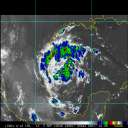
Chris is more or less holding its own this afternoon, in one of those "fits" that I mentioned a couple of times yesterday. Some enhanced northerly and northwesterly shear has helped keep the storm in check today, though it's not enough to seriously disrupt the storm. As that trough to its north fractures -- look at the strong northerly flow coming in near Bermuda -- and Chris moves further west, the environment will become more favorable.
It's not so much the SAL leading to this evolution as it is the shear plus the SAL; if you cut away the mechanism by which most of the dry air gets into the storm, you'll see its negative effects become greatly reduced. It's likely only a matter of 24-48 hours before that occurs, I believe. Long range San Juan radar hints at a mid-level eye feature, though recon has not noted at least a 50% eye in the most recent vortex. No matter the status of an eye, the storm still remains a strong TS and lopsided with most of its convection to the south and east.
Interestingly, the medium and deep layer BAM models are significantly further south than the shallow layer BAM model is, while the -- the strongest of the full physics models -- is also pretty far south. This suggests that there might be some sensitivity to the strength of the storm and the strength of the building ridge, wanting to nudge the storm a bit further south. It'd be nice for the US if that happened, providing a "check" of sorts on the intensity (whether by dynamical processes or by land), but I'm not sure of the validity of that evolution as of yet. Unfortunately, the sensitivity product is unavailable right now, while the ensembles do not capture the storm's structure well enough to make our confidence product very useful right now.
That said, forecast track and intensity thinking from last night still holds. Minimal hurricane within the next day or two, steady strengthening thereafter to cat 2/3 near the end of the period. I still think the cone and swath are a little too far south at 4-5 days, but only by 50 miles or so now; it's very reasonable at this time from my end. Regardless, everyone in the Greater Antilles, Bahamas, and south/central Florida need to watch this one for the weekend and into early next week. From there, the entire Gulf truly is at play, with a lot in the extended pattern still TBD. Stay tuned.
--------------------
Current Tropical Model Output Plots
(or view them on the main page for any active Atlantic storms!)
|


 Threaded


