jcarroll01
Registered User
Reged:
Posts: 3
Loc: Tampa, FL
|
|
Is there an area in the Hurricane activity area that has never been hit by a hurricane? some anomoly area that has never seen a direct hit due to some quirk or condition?
Just curious if anyone has just looked at every path since they are available and said...Wow....Hurricanes just never go there.
--------------------
"Sometimes nothing is a really cool hand"
|
Clark
Meteorologist
Reged:
Posts: 1710
Loc:
|
|
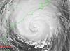
I'd say probably not, judging by this graphic 

--------------------
Current Tropical Model Output Plots
(or view them on the main page for any active Atlantic storms!)
|
GlenJohnson
Weather Hobbyist

Reged:
Posts: 61
Loc: Waldo Florida
|
|
That doesn't make me feel good. Picked the area between Gainesville and Jacksonville for the lack of Hurricanes.
--------------------
Be civil to all; sociable to many; familiar with few; friend to one; enemy to none.
Benjamin Franklin
Card carrying Storm Spotter
|
jcarroll01
Registered User
Reged:
Posts: 3
Loc: Tampa, FL
|
|
Cool. What is the source page for that graphic? I'd like to narrow it down little by little to see if I get something interesting by only going back 75 years or so.
Hurricanes cut such a wide swath that it would have to be a pretty significant "hole"....curious.
and thanks for the graphic....
--------------------
"Sometimes nothing is a really cool hand"
|
Clark
Meteorologist
Reged:
Posts: 1710
Loc:
|
|
I just pulled the image from a NOAA website after doing a Google image search for it. There are probably sites where you can create those sorts of images yourself, but I don't have the addresses on hand right now.
--------------------
Current Tropical Model Output Plots
(or view them on the main page for any active Atlantic storms!)
|
earthquake
Registered User
Reged:
Posts: 2
|
|
If my memory serves me correctly., I don't think the Houston/Galveston area has taken a hit in a long time.
|
ltpat228
Storm Tracker

Reged:
Posts: 201
Loc: Port Saint Lucie FL
|
|
Quote:
If my memory serves me correctly., I don't think the Houston/Galveston area has taken a hit in a long time.
Last hit was in 1943:
http://www.srh.noaa.gov/hgx/projects/hurr_1943.htm
|
carolt
Registered User
Reged:
Posts: 5
Loc: Ellaville, FL
|
|
This site narrows it down a bit:
wxrisk
|
saluki
Weather Hobbyist
Reged:
Posts: 57
Loc: Fort Lauderdale, FL
|
|
Quote:
That doesn't make me feel good. Picked the area between Gainesville and Jacksonville for the lack of Hurricanes.
I've lived in Florida for 20 years and the Jacksonville area has pretty much been spared during that time, as has the south coast of Georgia. I'm not sure if that's just good luck or if there's a climatological explanation for it. Perhaps those more knowledgeable about the science of tropical weather than I am can shed some light.
Edited by saluki (Sat Aug 18 2007 04:32 PM)
|
cjzydeco
Weather Guru

Reged:
Posts: 120
Loc: Sebastian, FL
|
|
The area north of Jacksonville and south of Cape Romain, SC, is known as the South Atlantic Bight. Here is a quote from "The Natural History of Georgia's Barrier Islands" by Taylor Schoettle. It helps to explain why this geophysical area has a lower potential for hurricane strikes.
Quote:
Georgia's barrier islands are actually the midsection of a system of oak-shrouded, sandy barriers that extend from the middle of the South Carolina coast to the mouth of the St. Johns River in Jacksonville, Florida. Georgia is the most westward location of the Atlantic seaboard, placing its barrier islands in the approximate center of the inward-curving coastline known as the South Atlantic Bight and 60 to 70 miles from the edge of the continental shelf (continental slope).
This position of the barrier islands relative to the South Atlantic Bight affects Georgia's tides, waves, and incidences with hurricanes. As oceanic tides, having an average range of 2 to 3 feet, funnel into the bight, the water piles up on itself, creating an elevated tidal range of 6 to 9 feet and making Georgia's tides the highest of the Atlantic seaboard south of New York. The shallow slope of the continental shelf, averaging about 2 feet per mile, dissipates the energy of the large waves coming in from the open ocean. Waves move across the broad, shallow shelf waters and lose energy as they drag along the bottom and break over the many offshore shoals before arriving on beaches. Since the Gulf Stream, in its wandering way, basically follows along the edge of the continental slope, Georgia's shores are also remote from the Gulf Stream. Hurricanes that approach our shores from the Atlantic tend to veer northward as they follow the warm air over the Gulf Stream, frequently causing them to miss our small 100-mile-long shoreline and make landfall farther north or go out to sea.
I also seem to remember from my meteorology course at CofC that there is a transition between global wind belts that affects this area as well. The subtropical high pressure belt is located right around 30N (the latitude of Jacksonville). North of there, the prevailing westerlies tend to help bend storms back to the east. The real mets probably have a better grasp on this than I, and I may be way off base.
--------------------
Lat/Lon: 27.8, -80.5
Frances '04, Jeanne '04, Wilma '05, Ernesto '06, Faye '08
|
LDH892
Meteorologist
Reged:
Posts: 13
Loc: Carolinas
|
|
Another good location for searching historical hurricane tracks can be found at the NOAA Coastal Services Center website . Short answer, there may be quiet periods where certain regions experience an absence in tropical activity, but IMHO there are no 'hurricane free zones'.
|
Beaumont, TX
Storm Tracker
Reged:
Posts: 318
|
|
Houston/Galveston was hit in 1983 by Hurricane Alicia.
|
neospaceblue
Weather Watcher
.gif)
Reged:
Posts: 28
Loc: Newport News, VA
|
|
Jacksonville was only hit by Hurricane Dora in 1964 and that was it.
--------------------
I survived: Hurricane Bonnie (1998), Hurricane Dennis (1999), Hurricane Floyd (1999), Hurricane Isabel (2003), Tropical Storm Ernesto (2006)
|
Montreal
Registered User
Reged:
Posts: 5
Loc:
|
|
Hi all !!!
First post here , I'm a 22 years old fanatic of weathers and everything related to it.
I live in Montreal so I'm a french speaker first but i'll try to use a good english for the forums.
4 or 5 years ago , I went to Oklahoma or a city close to it , not sure , and in 5 days I was ''lucky'' enough to see 2 tornadoes in front of my eyes.My cousin was going to have an heart attack but not me , I was pretty excited to say the least.I think I have the ''Storm Chaser'' in me .I'm actually working on it and want to make some beautiful videos and pics but that's not for today.
Sorry to do my presentation in this thread but I wanted to know , by looking at the picture , if an hurricane could really hit Montreal? Really curious as I thought it was ''impossible'' even if I dont like this word.
Can someone help me , cause I think I see a black lign in the picture hitting Montreal.
|
rhonlis
Unregistered
|
|
The Houston / Galveston area was hit by Hurricane Alicia in 1983.
This was already posted above. Please read carefully prior to posting.
Edited by Storm Cooper (Sun Sep 14 2008 07:28 PM)
|
LoisCane
Veteran Storm Chaser

Reged:
Posts: 1236
Loc: South Florida
|
|
Excellent read, written by Bill Read the now director of the ... thanks for posting it.
Not only was it a surprise but it is rarely referred to or referenced as if it never happened.
More the forgotten hurricane... found it doing research the other day and I realized I too forgot about the
serious WW2 Cane.
http://www.srh.noaa.gov/hgx/projects/hurr_1943.htm
Concern over shipping and politics and perception of our strength during war time kept publicity minimal. Also, newspaper accounts before it hit have gone down in history with inacurrate accounts.
Interesting paragraph:
"If it had crossed over the island instead of the Bolivar Peninsula, a large storm surge would have been pushed into the Bay area causing possibly a large loss of life, due to the lack of warning. People living along the northern and western shore of Galveston Bay would have been trapped to face the pounding waves and rising seas on land as low as five feet above sea level in many places. Compared with the damage that was done, who knows how bad the destruction and loss of live would have been."
Re: Alicia and the damage that downtown received... they seem to have received similar damage this time so what if anything was learned from Alicia that was not applied. And, did "hurricane glass" in newer building stand up? Do they use it there as they do in Miami.. I am wondering.
--------------------
http://hurricaneharbor.blogspot.com/
|


 Threaded


