MikeC
Admin
Reged:
Posts: 4544
Loc: Orlando, FL
|
|
Hurricane Julia was upgraded to a category 4 hurricane overnight, joining Hurricane Igor, meaning there are two category four storms active in the Atlantic at the same time. Bermuda should continue to monitor Igor very closely. Julia is out to sea, and it's likely anything else coming off from the cape verde this year will recurve.
This means in 2010 that so far there have been 4 major hurricanes, and all of the majors have made it to category four.
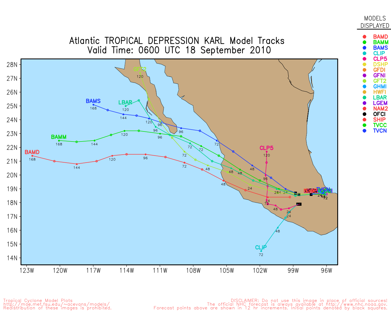
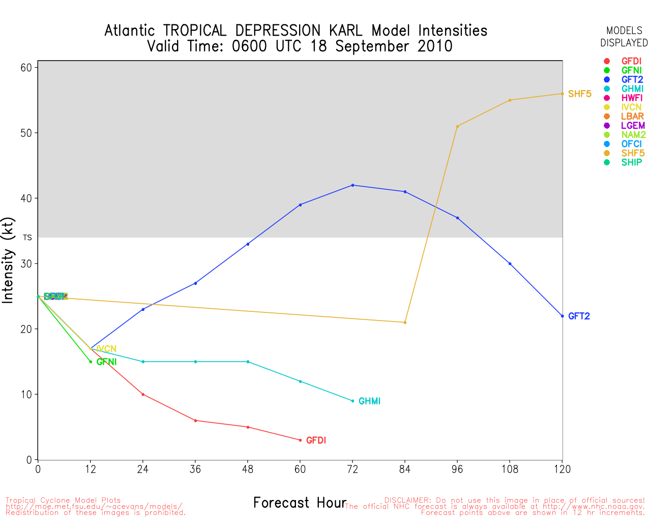
Tropical Storm Karl is strengthening as it is making landfall in the Yucatan. The official forecast has it restrengthening in the Bay of Campeche and becoming a hurricane before landfall near or just south of Tampico in Mexico. Those in the area will want to watch it closely.
It's now mid september and focus will be less on the Cape Verde systems, and more on the Caribbean and Gulf and closer Atlantic waters. The most likely spot for development next week will likely be in the Caribbean.

9:00PM EDT Updated - Tuesday, 14 Sept 2010
Tropical Storm Karl has formed in the Western Caribbean and is forecast to make landfall along the Yucatan peninsula tomorrow as a tropical storm. After which it is forecast to move into land near Tampico in Mexico as a Tropical Storm. Thankfully conditions appear it won't be much more than rainfall.
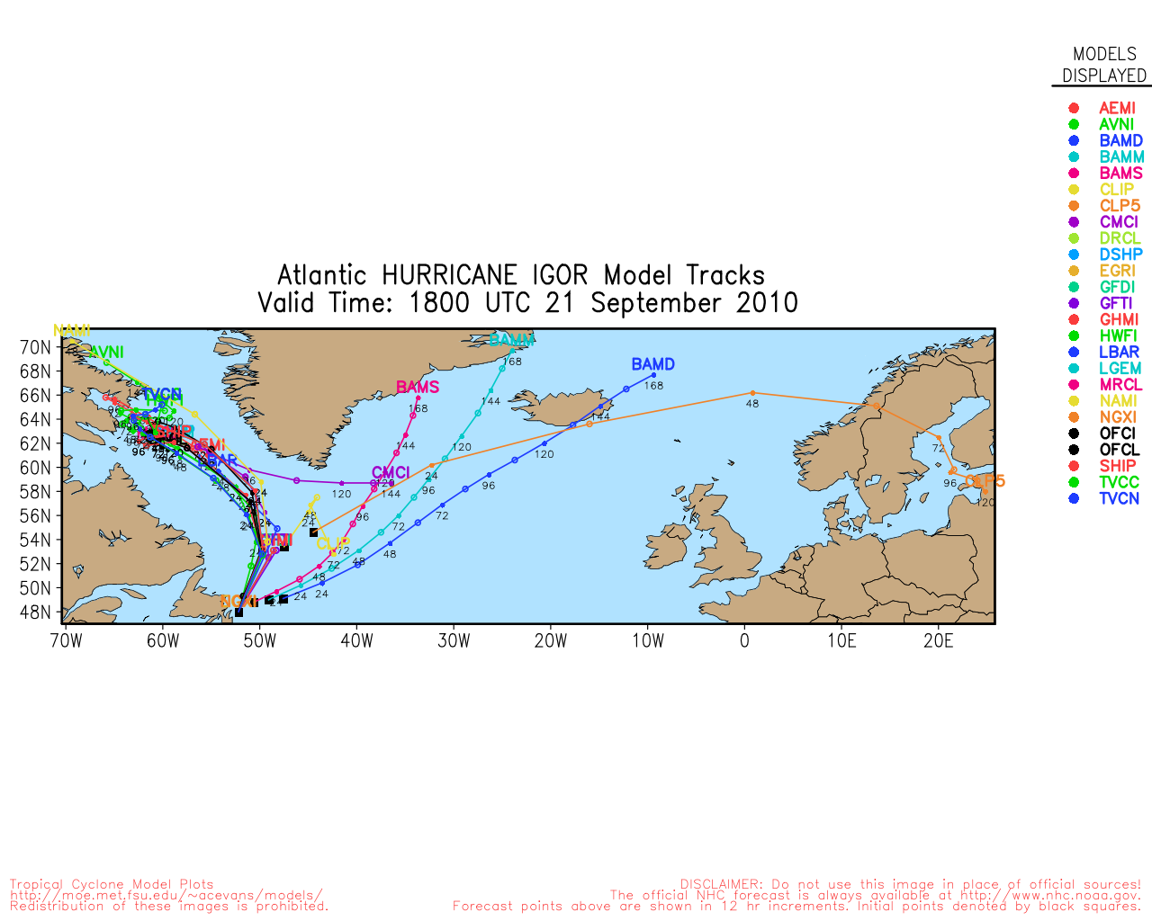
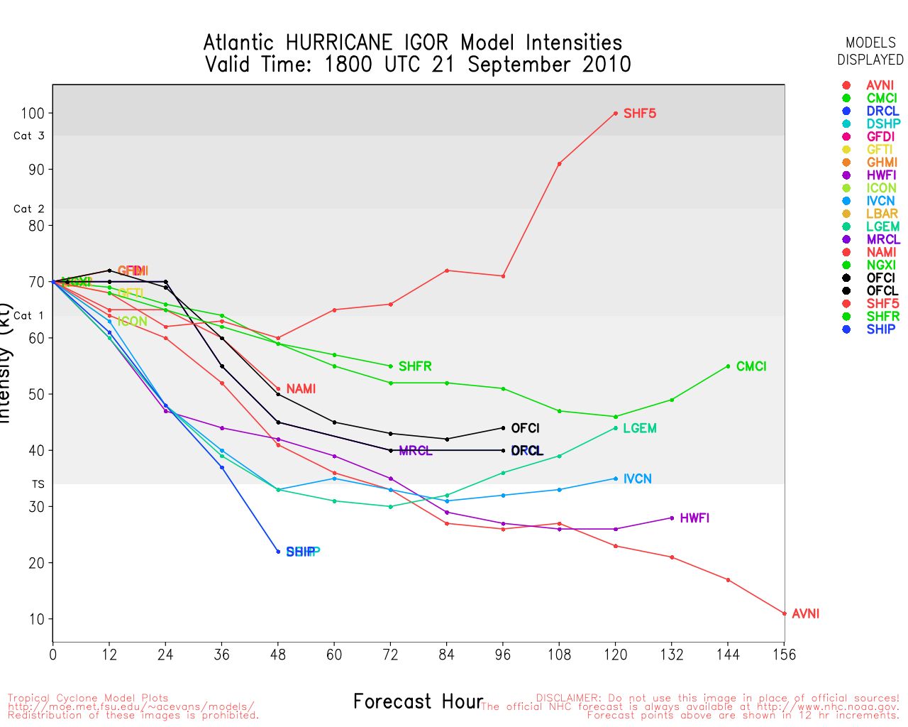
Igor is still a category 4 hurricane and the forecast track should keep Bermuda watching it closely, the forecast track for it seems fairly good.
Julia should remain well out to sea.
Three storms in the Atlantic, one a threat to Mexico for mostly rainfall, one a potential threat to Bermuda, and another no threat to land at all. None of the systems appear to be a threat to the United States.
3:45PM EDT Updated - Tuesday, 14 Sept 2010
Just a quick update to note that Tropical Storm Karl has formed in the Caribbean as found by Recon.
1:30PM EDT Updated - Tuesday, 14 Sept 2010
As two impressive hurricanes continue spinning far out to sea, a bit of a sneaker of a system which we have been following (Invest 92L) is now developing impressively in the favorable environment of the west-central Caribbean, and if current trends continue, advisories could very easily and quickly be issued for west Caribbean nations and/or their nearby islands later today or tonight. Interests in and around the western Caribbean, including the Yucatan peninsula, may want to start taking some tentative precautions for very heavy rain and stout wind, regardless.
Recon is currently back en route to Invest 92L.
7AM EDT Update - Tuesday, 14 Sept 2010
Igor has weakened a bit overnight, but not all that much, it is still a Category 4 hurricane. The expected turn to the north has begun, and it appears the Leewards will be spared the worst. Igor may get very close to Bermuda, it likely will be weaker near there, but it would still be a formidable hurricane. Those in Bermuda will want to watch very closely over the next several days.
Julia is now a Hurricane, as is already well on it's way to recurving.
The wave in the Caribbean (92L) had a bit too much land interaction and chances have dropped for its development but probably will rebound by the afternoon. It still is fairly likely to form before landfall in the Yucatan.
It is possible for a few more waves off Africa to develop, but recurves are most likely in any of the scenarios for another week or so. As the season goes deeper into the second half, more focus will be shifted westward.
12AM EDT Update - Monday, 13 Sept 2010
At 13/03Z upgraded TD12 to Tropical Storm Julia - the tenth named storm of the season. Julia was located about 110 miles to the southeast of the southern Cape Verde Islands and with movement to the west northwest becoming more northwest at 10mph, a Tropical Storm Warning has been issued for those southern islands. Julia is expected to become a Hurricane on Tuesday. Wih some factors favoring an increase in intensity and increasing windshear and cooler SSTs in a couple of days favoring a decrease in intensity, the intensity forecast beyond Tuesday could see some fluctuations.

Igor is...well, simply an amazing storm with sustained Cat IV winds now at 130 knots and the possibility of 140 knots (Cat V) by 12Z on Monday. Although some erosion has been noted on the southeast core, this could simply be associated with the directional change of the past few hours to slightly south of due west, and there is a pocket of drier air ahead of the system for the next couple of days but its not that significant. Near-term motion to the west and west northwest is anticipated, however, the long term is still a bit uncertain with a few models hinting at a turn back toward the west northwest, i.e., the weakness in the ridge does not fully capture the system. However, at the moment this is still an outlier scenario - but folks in the northern Leeward Islands should closely monitor Igor and wait for the expected turn to the northwest.
Invest 92L is located south of the western tip of Haiti moving slowly to the west northwest and Jamaica can anticipate heavy rain squalls on Monday. The system is very disorganized and shows no sign of near-term development.
ED
{
7:00PM EDT Update Sunday, 12 September 2010
Hurricane Igor has strengthened into a Category 4 hurricane today, and may strengthen a bit more before weakening. Odds continue to favor it recuring before nearing land, but it will have to be monitored to see if anything changes.

The wave in the Caribbean (92L) is bringing some rainfall into Haiti now, if it develops it won't be for another day or so.
9:00AM EDT Update Sunday, 12 September 2010
Hurricane Igor continues to look impressive on Satellite and is moving generally westward at about 18MPH. The current forecast track keeps the cone northeast of the Leeward islands, but those there should continue to watch until the northward movement verifies. Odds currently favor Igor recurving before the Islands. Beyond that, odds favor recurve before reaching the us, but trends may move it westward, and another "Earl-Like" situation could develop. However, odds are it will stay offshore.
The wave in the Central Caribbean (92l) stil has a 50/50 shot of development over the next two days, it becomes more likely as it nears the western Caribbean. Once there those in the Yucatan, and westward into Southern Mexico will want to watch it.
The system off Africa, 93L, has formed into Tropical Depression 12, and advisories will likely start at 11AM EDT this morning. Odds are extremely high this too will recurve out to sea.
8:30AM EDT Update Saturday, 11 September 2010
This morning there is Tropical Storm #Igor, now on the verge of becoming a hurricane. Igor's odds still favor out to sea currently, but the Leeward islands will want to watch since they are in the cone. It would approach the islands until Thursday or Friday if it did.
The wave in the Caribbean (92L) still has a shot to develop before the end of the weekend (60% now), so those in Jamaica, Caymans, CUba, and the Yucatan Peninsula including Belize will want to continue watching it. Odds favor it remaining generally west and south so it may be a threat for other parts of Mexico later as well.
93L is a wave that has just come off the coast of Africa, and already has a good pattern to allow it for development into a tropical depression or storm, odds favor this going out to sea as well, but there are several opportunities where that could change. It currently has a 30% chance to develop within the next two days.
6PM EDT Update Friday, 10 September 2010
Not too much has changed since yesterday on Igor and 92L. Igor has regained some strength and has a good shot to become a major later on, but still looks like odds favor it staying out to sea. Still a lot of time for things to change, however.
92L is about a 50/50 for development over the weekend, and it's still is worth watching for Western Caribbean Islands and the Yucatan, and odds favor it staying south, but again it's worth watching for changes.
Flhurricane recording of French Atilles Radar for 92L
7AM EDT Update Thursday, 9 September 2010
Igor is not moving, and at this far out in the Atlantic it's likely to cause a very long delay before it heads more west, it has remained weak as well. The official forecast keeps it still in the Central Atlantic into the middle of next week. Odds strongly favor the system staying out to sea once past the Cape Verde, and it may become a major hurricane while doing so.
Outside of this, Ex-Gaston is over Hispaniola and is causing rains in Haiti, but does not look to develop anytime soon. Another area in the Leeward islands may have to be watched as it moves westward, but for now it's not an official "Invest" area. (Update: Just minutes after this was written, 92L gets designated) This system has a good shot for development when this system arrives in the western Caribbean, and is probably the most worthy of being watched of all the areas (For affects to land. m Highest chances currently are for western Caribbean islands (Caymans/Jamaica/Cuba), Belize, Yucatan, and Mexico westward). Although for track it is still a developing system, so things can change.
If it were to develop, Saturday/Sunday seems to be most likely.
Over Africa another wave may emerge that could develop, but that also is trending toward a recurve.
In short, one storm that looks to recurve, and a few unlikely areas that need to be watched for development later is pretty good news for the peak of the season. However, this is also the time to watch for surprises (like Hermine).
Original Update
Tropical Storm Warnings are up for the Cape Verde islands off Africa as Tropical Storm Igor forms in the Eastern Atlantic.
It is forecast to move westward and strengthen into a hurricane. Odds slightly favor Igor staying out to sea, but long range uncertainties make it worth watching through the week into next.
This is going to take a while to cross the Atlantic-- any affects on the Caribbean islands would not be seen until late next week.
More to come later.
|
stormtiger
Weather Hobbyist
Reged:
Posts: 73
Loc: Baton Rouge, La.
|
|
On Sept. 5th Mr. Dunham wrote a nice piece on how it looked like conditions were that we might hit a lull during the peek of what was forecasted to be a busy season.
Since his blog, we have had two named storms and it's just Sept. 8th.
Early in June and July many of us felt we were on the verge of having several tropical systems to track; however, only one in June and one in July came to fruition. It seemed no matter how warm the waters were and how light the sheer was, it was hard to get things to pop.
Now we see the opposite in a sense. conditions aren't ideal, but a system in the GOM took off quickly, and one in the Far East Atlantic just became Igor. It seems climatology is a huge factor.
So much for the lull.
Let's hope the season continues as we've seen and all the major storms follow the central Atlantic path.
|
Jasonch
Weather Watcher
Reged:
Posts: 42
Loc: Texas
|
|
This probably will be another fish storm.
|
Storm Hunter
Veteran Storm Chaser

Reged:
Posts: 1370
Loc: Panama City Beach, Fl.
|
|
long range Euro is looking interesting... takes Igor into a deep tropical cyclone as he passes north of Islands.... Model has done pretty good with this coming off of Africa
--------------------
www.Stormhunter7.com ***see my flight into Hurricane Ike ***
Wx Data: KFLPANAM23 / CW8771
2012== 23/10/9/5 sys/strms/hurr/majh
|
Jasonch
Weather Watcher
Reged:
Posts: 42
Loc: Texas
|
|
Quote:
On Sept. 5th Mr. Dunham wrote a nice piece on how it looked like conditions were that we might hit a lull during the peek of what was forecasted to be a busy season.
Since his blog, we have had two named storms and it's just Sept. 8th.
Early in June and July many of us felt we were on the verge of having several tropical systems to track; however, only one in June and one in July came to fruition. It seemed no matter how warm the waters were and how light the sheer was, it was hard to get things to pop.
Now we see the opposite in a sense. conditions aren't ideal, but a system in the GOM took off quickly, and one in the Far East Atlantic just became Igor. It seems climatology is a huge factor.
So much for the lull.
Let's hope the season continues as we've seen and all the major storms follow the central Atlantic path.
Isn't it funny some people seem to think they have it all figured out. The conditions are perfect ( no wind shear, warm water) and then the second something forms and it has a hard time getting going then that is when they realized the conditions weren't so perfect. Nobody has a clue what the conditions are until the storm is out there. Gaston was a perfect example of that.
|
Ed Dunham
Former Meteorologist & CFHC Forum Moderator (Ed Passed Away on May 14, 2017)
Reged:
Posts: 2565
Loc: Melbourne, FL
|
|
For clarification, suggest that you might want to re-read the entire article. While I did mention the possibility that the peak of the season might be quiet (with Igor that no longer is true), I think that I may have mentioned something about activity in the southwest GOM and something about a wave that would exit Africa in two or three days.
Because Meteorology is the youngest of the natural sciences and therefore far from an exact science, we offer the Forecast Lounge for you to offer your thoughts - without retribution.
The intent of the Blog was not to imply that there would not be further storms this season - but it seems that I must have left that impression - which was not intended. Climatology expresses something in averages - and extremes.
ED
|
rgd
Weather Hobbyist
Reged:
Posts: 65
|
|
Quote:
long range Euro is looking interesting... takes Igor into a deep tropical cyclone as he passes north of Islands.... Model has done pretty good with this coming off of Africa
Yup looking that way.Some are trying to pull straws and find different but it looks like another fishy
|
berrywr
Weather Analyst

Reged:
Posts: 387
Loc: Opelika, AL
|
|
Models have done pretty darn good all season! Let me see, 24 degrees W; what's that...3 weeks to reach 80 degrees W at 7 mph? What to do...what to do...
--------------------
Sincerely,
Bill Berry
"Survived Trigonometry and Calculus I"
|
bobbutts
Weather Hobbyist

Reged:
Posts: 71
Loc: New Hampshire
|
|
oops, mentioned 92L but it's already in the news item.
If this system develops, it's in a location where it would be very difficult to find a track that doesn't affect land.
Edited by bobbutts (Thu Sep 09 2010 04:11 PM)
|
MikeC
Admin
Reged:
Posts: 4544
Loc: Orlando, FL
|
|
Site Note: Our primary image server is down at the moment, so some images may not appear.
|
ftlaudbob
Storm Chaser

Reged:
Posts: 828
Loc: Valladolid,Mx
|
|
Igor is back to TS status and looking rather well.Still too early to tell if he will re curve or continue west.There doesn't seem to be of much interest in here yet,but that could change by next week.
--------------------
Survived: 10 hurricanes in Rhode Island,Florida and the Yucatan of Mexico .
|
MikeC
Admin
Reged:
Posts: 4544
Loc: Orlando, FL
|
|
Not too much has changed since yesterday on Igor and 92L. Igor has regained some strength and has a good shot to become a major later on, but still looks like odds favor it staying out to sea. Still a lot of time for things to change, however.
92L is about a 50/50 for development over the weekend, and it's still is worth watching for Western Caribbean Islands and the Yucatan, and odds favor it staying south, but again it's worth watching for changes.
The ZImmerman fhurricane image server is still down at the moment, but I've rewired part of it to use alternates, and more images should begin to appear over time.
|
typhoon_tip
Meteorologist
Reged:
Posts: 576
|
|
Igor:
If I didn't know any better I'd see we just recently have a center relocation closer into a suddenly very symmetrical looking system, replete with at least a quasi-CDO feature. This is taking place across the last hour and currently.
Edited by typhoon_tip (Fri Sep 10 2010 10:51 PM)
|
Ed Dunham
Former Meteorologist & CFHC Forum Moderator (Ed Passed Away on May 14, 2017)
Reged:
Posts: 2565
Loc: Melbourne, FL
|
|
It was really difficult to know for sure - having to deal with IR imagery, but it looked to me like the center was realigning a little more under the convection. Perhaps near 17N 34W. The easterly shear certainly is declining.
ED
|
typhoon_tip
Meteorologist
Reged:
Posts: 576
|
|
Guidance continues to shift westward with the track of Igor, including this most recent run of the as of 18Z. It is important to note that forecast errors expand to as much as 300 miles by Day 5. This implies that the people in the northern Leeward Islands should at least begin monitoring the progress of Igor, and the official forecasts for their area over the next 5 days.
|
typhoon_tip
Meteorologist
Reged:
Posts: 576
|
|
Outflow in the cirrus field is improving dramatically as the evening presses onwards. The wind overlays at TPC even support a few vectors that are opposing the shear from earlier in the day. Given the apparent repositioning (and we await the final say from upstairs) combined with this intense IR show intensifying with a bit more certitude is likely underway.
|
berrywr
Weather Analyst
Reged:
Posts: 387
Loc: Opelika, AL
|
|
Good evening...Igor finally has gotten his wings and is on the move west. We have about a 5 day window before we're going to know whether recurvature lies in Igor's future.
For the moment the models beyond 5 days have Igor approaching a COL between two ridges and a shortwave to the north at 30.0N and 73.0W. Igor will slow and spend a few days in this vicinity if the models verify and has a future date being caught up in the westerlies.
There is model difference as expected in the longer ranges and all are focused on the strength of the subtropical ridge in the Atlantic.
Turning to the wave in the Caribbean; the models take this feature west and emerge it over the Pacific in five days.
I'm aware there is a wave expected to develop and trail Igor but it's way too early to speculate since this wave is over Africa as of this typing.
--------------------
Sincerely,
Bill Berry
"Survived Trigonometry and Calculus I"
|
RevUp
Weather Guru
Reged:
Posts: 181
Loc:
|
|
92L is looking much more favorable for further development and classification this morning ... showers on the increase toward PR-VI and SFC pressures lower.
42060 5-day mslp plot
--------------------
"Let tomorrow worry about itself. Each day has enough trouble of its own."
Edited by RevUp (Sat Sep 11 2010 12:29 PM)
|
typhoon_tip
Meteorologist
Reged:
Posts: 576
|
|
Shortly after Igor's improved display during the overnight he began ingesting SAL contaminant as can be seen here:
http://cimss.ssec.wisc.edu/tropic/real-time/wavetrak/winds/m8split.html
This will likely impeded much further intensification in the shorter terms, but should not prove to end Igor by any means. This is not a major hindrance looking out in time as we can see this is a single arcing band that has gotten caught up in Igor's large circulation field. Every system (Danielle, Earl...etc) thus far this season demonstrated a weakening trend when passing Igor's current latitude/longitude, and in each case SAL material was present and could be seen using this product to be ingesting into the systems.
92L:
...Has a much improve satellite performance this morning and feels pretty strongly that a depression will be forming here imminently.
Guidance is spread ... ranging from not seeing much of anything even there, to moving toward the PR archipelago, to a Caribbean Cruiser eventually terrorizing the western ends of the region. It is not likely the models will be in much consensus until a real entity shows up better in the initializations.
|
berrywr
Weather Analyst
Reged:
Posts: 387
Loc: Opelika, AL
|
|
Thanks Tip! I looked at everything you just wrote about and I'll add this one other tidbit...there is also quite a bit of dry and subsidence air entraining into the system from the west and north confirming your SAL analysis; however the SAL isn't as strong as previous systems and it will be short lived as Igor tracks west.
--------------------
Sincerely,
Bill Berry
"Survived Trigonometry and Calculus I"
|


 Threaded


