MikeC
Admin
Reged:
Posts: 4544
Loc: Orlando, FL
|
|
7:30 AM EDT 26 July 2013 Update
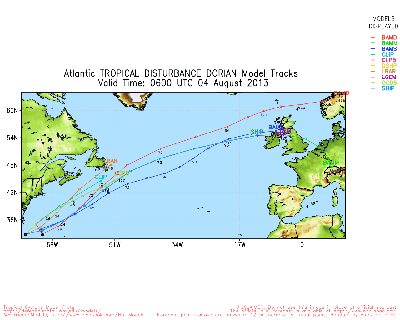
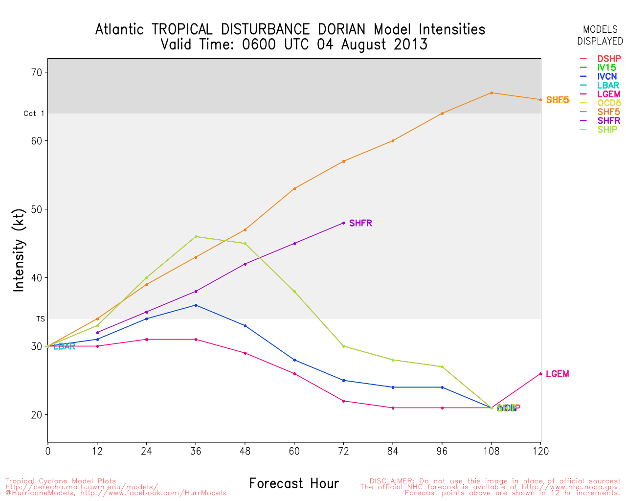
Tropical Storm Dorian has had an injection of moisture cut of, and is about to ply into a relatively dry area ahead of it, combined with the small size and these factors, Dorian could fall apart today and open up into a wave, if it does, it may recover later when conditions aren't quite as hostile. Dorian still has a close low level circulation, and is small so swings in intensity like this were anticipated.
If it manages to survive then it would likely continue along the west northwest path, and skirt just to the north of the Caribbean islands early next week, so it will need to be watched for a while.
Shear is only a mildproblem, and water temperature is not a problem at all for the system.
10:30 AM EDT 24 July 2013 Update
Tropical Storm Dorian forms in the Eastern Atlantic, still moving generally west northwest at a quick rate. Dorian is a relatively small storm and likely will see quite a few intensity changes over the next few days, both up and down.
3:45AM EDT 24 July 2013 Update
Invest 98L has become a tropical depression, the fourth of the 2013 Atlantic Hurricane Season. Movement is to the west-northwest at around 20 MPH, and this general track is forecast to hold for several days.
It is very likely that FOUR becomes TS Dorian today. Near term, conditions for rapid development are not expected, but it is possible that FOUR becomes the first hurricane of the season sometime this week. The average date of formation of the first hurricane of the Atlantic Hurricane Season is August 10.

Ciel
Original Post
After a quiet few weeks after Chantal, another wave bears watching out in the far eastern Atlantic. Being tracked as "98L" it will likely move generally westward and has a low to moderate chance to develop over the long haul. Other areas may pop up closer before it makes it all the way westward.
Since it is so far out and has quite a bit of hurdles to go through, and only marginally favorable conditions both in the atmosphere and with sea surface temperatures, it could remain weak for a while. Long term models keep it going generally westward, so those in the northeastern Caribbean will want to follow the progress for this weekend. Beyond that is to soon to tell, but there is nothing to suggest a hard north turn currently.
As of now the wave has a 30% chance for development over the next few days, and this one may never truly develop.
|
Random Chaos
Weather Analyst

Reged:
Posts: 1024
Loc: Maryland
|
|
NWS now gives it a 60% chance of development. Just barely off edge of GOES East coverage tonight, should have a better timelapse view of the wave tomorrow.
NRL has a good picture of it from a few hours ago. Looks pretty well organized.
Link: - http://www.nrlmry.navy.mil/TC.html
|
danielw
Moderator

Reged:
Posts: 3525
Loc: Hattiesburg,MS (31.3N 89.3W)
|
|
Wave is now TD4. Expected to become TS Dorian shortly. Outflow channels are good. With the northern outflow channel being a bit weaker. Cloud tops nearing 60,000 feet, per Brohav weather.
|
Random Chaos
Weather Analyst
Reged:
Posts: 1024
Loc: Maryland
|
|
Already showing some nice banding for a TS:
http://www.ssd.noaa.gov/PS/TROP/floaters/04L/flash-rbtop-short.html
|
Random Chaos
Weather Analyst
Reged:
Posts: 1024
Loc: Maryland
|
|
Looking somewhat anemic today - shear and dry air taking a toll on it.
Still racing westward.
|
Hawkeyewx
Weather Analyst
Reged:
Posts: 99
|
|
It appears Dorian may barely be hanging onto tropical cyclone status. The circulation is much less potent/organized than it was a day ago.
At some point one of these central/east Atlantic systems will survive and prosper and perhaps cause trouble.
|
ftlaudbob
Storm Chaser

Reged:
Posts: 828
Loc: Valladolid,Mx
|
|
As I said in the forecast lounge,the moisture it was getting from the south has been cut off,that was a life line that kept it going through a hostile environment.But it is coming into warmer SST's,so it is a coin toss if it survives.
--------------------
Survived: 10 hurricanes in Rhode Island,Florida and the Yucatan of Mexico .
|
danielw
Moderator
Reged:
Posts: 3525
Loc: Hattiesburg,MS (31.3N 89.3W)
|
|
Tropical Storm Dorian continues to struggle against a dry air environment and wind shear. However, the latest enhanced satellite images suggest the system is still alive and in fairly good shape considering the odds.
Mid level outflow, feather like cirrus fingers, are present from NNW through to the ENE sectors.
The green denotes the highest cloud tops, most are centrally located. Although they aren't clustered.
The darker shades of white, grey and black are areas of moist air, what's left of it.
It appears that Dorian is still somewhat encased in a small pocket of moisture. The orange-red is drier air ahead of the system.

Bottom image is zoomed out to show the atmosphere in the area and the storm's proximity to the Lesser Antilles and Puerto Rico.

|
Random Chaos
Weather Analyst
Reged:
Posts: 1024
Loc: Maryland
|
|
It's dead, Jim.
NHC:
"
ASCAT AMBIGUITY DATA FROM A FEW HOURS AGO INDICATED THAT DORIAN NO
LONGER HAD A CLOSED SURFACE CIRCULATION. THUS...THE TROPICAL
CYCLONE HAS SUCCUMBED TO THE HARSH ENVIRONMENT AND HAS DEGENERATED
INTO A TROPICAL WAVE.
"
|


 Threaded


