Kraig
Weather Hobbyist

Reged:
Posts: 68
Loc: Jupiter, Fl
|
|
Quote:
Another tweak to the west at 2PM. Hope those on the west coast have been paying attention... it sounds like they have.
Had to create a new account my previous one wouldn't log in despite resetting my password (twice in fact).
"At 200 PM EDT (1800 UTC), the distinct eye of Hurricane Irma was
located by a reconnaissance plane and Cuban radars near latitude
22.0 North, longitude 76.0 West. Irma has been moving toward the
west near 14 mph (22 km/h), but the hurricane should resume a
west-northwest motion later today."
Wonder if this movement to the west is a prolonged wobble influenced by the Cuban topography....blocking off some of the southern inflow and drawing Irma to the south?
--------------------
2022 forecast 21/11/4; 0/0/0 as of 6/1
South FL Native: David ('79), Floyd ('87), Andrew ('92), Georges ('98), Irene ('99), Charlie, Frances & Jeanne ('04), Wilma ('05), Matthew ('16), Irma ('17), Dorian ('19) and Isaias (20)
|
islandtime
Registered User
Reged:
Posts: 6
|
|
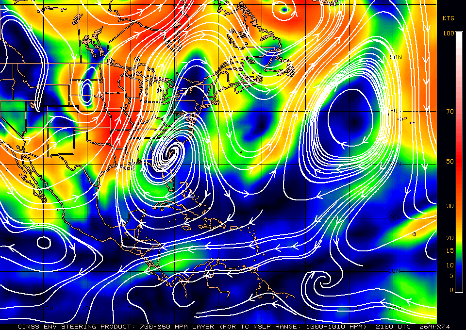
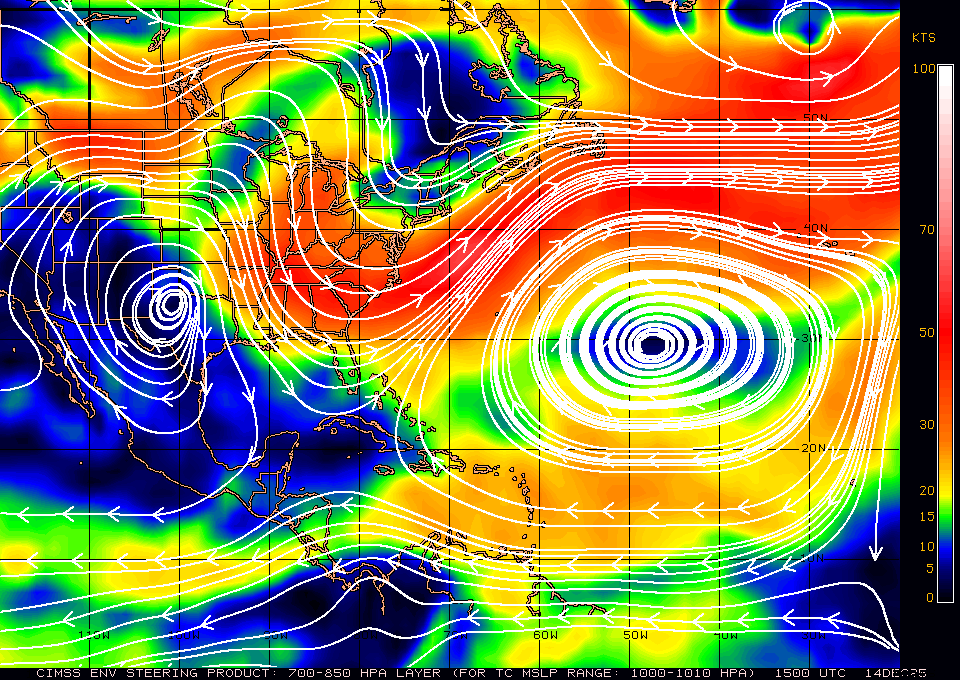
Can someone explain the difference between the steering currents this time yesterday and the one from today? Yesterday i could see the reasoning of the "cog" effect of the high and low pulling the storm northward. Today it looks like the currents should continue taking it west.
Yesterday:
Today:
|
scottsvb
Weather Master
Reged:
Posts: 1184
Loc: fl
|
|
A wobble NW is happening.. but it should continue more W or 275dg through the evening and tonight
|
MikeC
Admin
Reged:
Posts: 4544
Loc: Orlando, FL
|
|
12Z slight shift west, euro slight shift west. Sunday morning, landfall near Long key, then lanfall near Flamingo Sunday afternoon. passes north over winter haven, and goes just west of orlando and in Atlanta by early Tuesday morning.
12Z Euro slight shift west, but into Cuba, Keys landfall Sunday morning near Marathon, Mainland Florida landfall sunday affternoon near Everglades City, cat 4/5 then up over lakeland, Ocala, and Gainesville. Hurricane force winds extend east/west the entire state.
12Z UkMet shifts EAST and does a bare scrape of Cuba (prior it was west and well into Cuba) but remainder of the track is like the Euro.
|
abyrd
Weather Hobbyist
Reged:
Posts: 62
Loc: apopka
|
|
Quote:
[quote
Wonder if this movement to the west is a prolonged wobble influenced by the Cuban topography....blocking off some of the southern inflow and drawing Irma to the south?
I thought so too, but the last couple of satellite frames show a turn back wnw. Just a long wobble.
|
chase 22
Weather Hobbyist

Reged:
Posts: 82
Loc: San Angelo, TX
|
|
Quote:
Can someone explain the difference between the steering currents this time yesterday and the one from today? Yesterday i could see the reasoning of the "cog" effect of the high and low pulling the storm northward. Today it looks like the currents should continue taking it west.
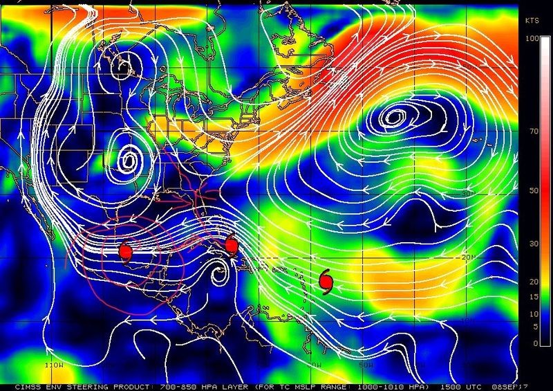
Maybe this clears it up. (Disclaimer: Track not exactly accurate lol!)
--------------------
Matt
|
Kraig
Weather Hobbyist
Reged:
Posts: 68
Loc: Jupiter, Fl
|
|
Quote:
12z Euro slight shift west, but into Cuba, Keys landfall Sunday morning near Marathon, Mainland Florida landfall sunday affternoon near Everglades City, cat 4/5 then up over lakeland, Ocala, and Gainesville. Hurricane force winds extend east/west the entire state.
Hurricane force winds extend east/west the entire state. = meaning peninsular Florida, not the "entire state" including the panhandle....correct?
--------------------
2022 forecast 21/11/4; 0/0/0 as of 6/1
South FL Native: David ('79), Floyd ('87), Andrew ('92), Georges ('98), Irene ('99), Charlie, Frances & Jeanne ('04), Wilma ('05), Matthew ('16), Irma ('17), Dorian ('19) and Isaias (20)
|
islandtime
Registered User
Reged:
Posts: 6
|
|
Quote:
Quote:
Can someone explain the difference between the steering currents this time yesterday and the one from today? Yesterday i could see the reasoning of the "cog" effect of the high and low pulling the storm northward. Today it looks like the currents should continue taking it west.
Maybe this clears it up. (Disclaimer: Track not exactly accurate lol!)
How are the lines moving east to west that the storm is in now (in the image) not keeping it going west?
|
M.A.
Weather Guru
Reged:
Posts: 108
Loc: Vero Beach, Fl
|
|
The way I see that chart, the winds are less than 10knts. So the steering currents are not all that strong. We know that a storm this size doesn't exactly read all the papers telling it what it should be doing.
|
M.A.
Weather Guru
Reged:
Posts: 108
Loc: Vero Beach, Fl
|
|
Irma's eye seems to be getting less occluded on the last couple of frames of the visible sat. End of an ? WNW wobbles. I believe it stays off the northern coast of Cuba and this track.
|
Lamar-Plant City
Storm Tracker

Reged:
Posts: 383
Loc: Plant City, Florida
|
|
Quote:
The way I see that chart, the winds are less than 10knts. So the steering currents are not all that strong. We know that a storm this size doesn't exactly read all the papers telling it what it should be doing.
I believe that is a wind shear map....so the shear is at 10 knts....which is pretty low.
--------------------
If you don't like the weather, wait 5 minutes...
2023 Season Prediction: 17/6/2
|
JMII
Weather Master

Reged:
Posts: 489
Loc: Margate, Florida
|
|
Beginning to rethink my plan. Might be worst here in Sebring that back home in Margate/Coral Springs if we get any more westward shifts. The problem here in central-ish FL are the trees - so many big, mature trees, like massive oaks and pines. I have no such around my house in the 'burbs.
Got my previous account working again, password reset just takes longer.
--------------------
South FL Native... experienced many tropical systems, put up the panels for:
David 79 - Floyd 87 - Andrew 92 - Georges 98 - Frances 04 - Wilma 05 - Matthew 16 - Irma 17
Lost our St James City rental property to Ian 22
|
tracerrx
Registered User
Reged:
Posts: 4
Loc: Fort Lauderdale, FL
|
|
Also decided to stay in Boca (New house, hurricane glass, genset) instead of our place in sebring. Was worried about being able to get back from Sebring -> East Coast
|
B.C.Francis
Storm Tracker
Reged:
Posts: 331
Loc: Indiatlantic Florida
|
|
I think you made a good move
|
Lamar-Plant City
Storm Tracker
Reged:
Posts: 383
Loc: Plant City, Florida
|
|
If you follow the latest projected track..look at where it passes right between Hillsborough and Polk counties....and that is my house...right THERE! I really don't want to be to the right of this storm track....really....if it keeps going west, we may relocate the whole kit and kaboodle to my mom's place in Lake Wales....it is on the right but would be much farther from the core....dang!
--------------------
If you don't like the weather, wait 5 minutes...
2023 Season Prediction: 17/6/2
|
MikeC
Admin
Reged:
Posts: 4544
Loc: Orlando, FL
|
|
18Z run, scrapes Cubas north coast (offshore), landfall cat 5 just east of Key West (which is a shift west of the 12Z run) late Sunday morning, mainland landfall south of Napes, Cat 5 late Sunday.
Over Wauchula, FL early Monday morning, cat 3/4 Cat 3 Over Bushnell by late Monday morning. Hurricane force winds extend all the way along the peninsula east and west through this point. Near live oak/Lake City, FL Monday afternoon, Cat 1/2, winds dying down either way. Worse winds (additive effect relative to forward motion) on right side. West side has negative effect on windspeed due to forward motion. The rides up I-75 into Georgia weakening the whole way. (Atlanta will get some TS winds)
|
OrlandoDan
Weather Master

Reged:
Posts: 443
Loc: Longwood, FL
|
|
So Orlando looks like it will be on the strong side of the storm now. I spent the entire day boarding up. What a pain due to the rock facade on the concrete block. Have to cut pieces of 2x4 and drill those into the block on the window frame and then perfectly cut plywood to screw into those. Took me 10 hours to do the remaining half of the windows that I had not done for Mathew.
Looks like another shift west would not be unreasonable now. We shall see.
--------------------
Keith (1988), Charley (2004), Frances (2004) , Jeanne (2004), Fay (2008), Mathew (2016), Irma (2017), Dorian (2019)
Personal Weather Station: https://www.wunderground.com/dashboard/pws/KFLLONGW67
|
MikeC
Admin
Reged:
Posts: 4544
Loc: Orlando, FL
|
|
Wanted to repost this from Mike Watkins
Don't be a wobble watcher!
The forecast for Irma has shifted subtly west over the last 24 hours.
If you're in Naples, the natural inclination is "this is bad news for us".
If you're in Miami, it's easy to believe this to be good news, and I've seen many posts that express relief.
The meteorological reality is this: neither are true.
Both sides of the coast are under a hurricane warning since last night, which means hurricane conditions are possible in either location.
In fact, I would bet every dollar I have that in 48 hours from now, Irma will not be exactly on the 2PM Sunday forecast position even though the forecast models are in tight agreement. Why? Agreement DOES NOT EQUAL accuracy.
At this time yesterday the forecast thinking was reversed. 2 days ago, west was bad, east was good.
Our ability to forecast exactly where the worst winds will be in 2 days is not 100% accurate. What happens if the model runs tonight shift back east? Then what?
We know that the odd shape of the Florida coast makes even a tiny shift in track huge for someplace. Remember was supposed to go to Tampa, and it made a last second right turn?
This is a VERY complex situation, meteorologically speaking. The exact timing of the trough over the northeast, the short-wave diving in from the mid west, and the hurricane's inner mechanics all are unknown. Our models and forecasters can make predictions on what we know, but like always, we don't know what we don't know.
This is why it is extremely important that residents on both sides of the peninsula prepare for the worst. Do not let your guard down and do less tonight because it "doesn't look as bad for you". It's easy to think that way when you're tired, and we're all tired from preparing and watching every single update. Don't let the tired lead to a bad decision. This is not a sprint, it's a marathon.
Sooner than any of realize, the time to prepare safely will be out. It could be as early as Saturday afternoon. Don't watch the wobbles. Prepare for the worst, and hope for the best. If it misses your house, be thankful afterwards, and sleep tonight knowing you've done everything you can to prepare.
Mike
|
OrlandoDan
Weather Master
Reged:
Posts: 443
Loc: Longwood, FL
|
|
Lamar. Best of luck to you. As bad as it may be, it's good that you prepared.
--------------------
Keith (1988), Charley (2004), Frances (2004) , Jeanne (2004), Fay (2008), Mathew (2016), Irma (2017), Dorian (2019)
Personal Weather Station: https://www.wunderground.com/dashboard/pws/KFLLONGW67
|
JMII
Weather Master
Reged:
Posts: 489
Loc: Margate, Florida
|
|
Quote:
Was worried about being able to get back from Sebring -> East Coast
I'm worried about just getting one block down the street. That is after climbing out from under a house that has an oak tree sitting on top of it.
Quote:
Don't be a wobble watcher!
But are these wobbles or trends? Yesterday we had plenty of the "wiper effect" with the models flipping back and forth - east coast / west coast. 20 miles here or there suddenly starts to add up. I know Andrew was much smaller/more compact system but as I posted a few days ago (feels like weeks) there was a remarkable difference in damage from southern Broward, to central Dade, to southern Dade.
Irma looks to encounter some strong shear (finally!) about 1/2 way up the state which should allow some weakening during her run north. Right now that is what I'm counting on.
--------------------
South FL Native... experienced many tropical systems, put up the panels for:
David 79 - Floyd 87 - Andrew 92 - Georges 98 - Frances 04 - Wilma 05 - Matthew 16 - Irma 17
Lost our St James City rental property to Ian 22
|


 Threaded


