MikeC
Admin
Reged:
Posts: 4813
Loc: Orlando, FL
|
|
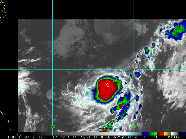
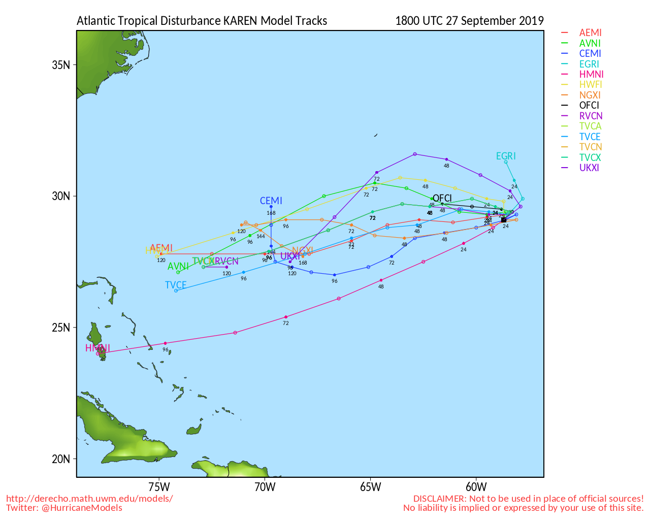
6:00 AM EDT Update 26 September 2019
Tropical Storm Karen is barely a Tropical storm this morning and now forecast to weaken into an open wave, meaning it will most likely dissipate in the future because of hostile conditions, which is good news. We'll continue to monitor it.
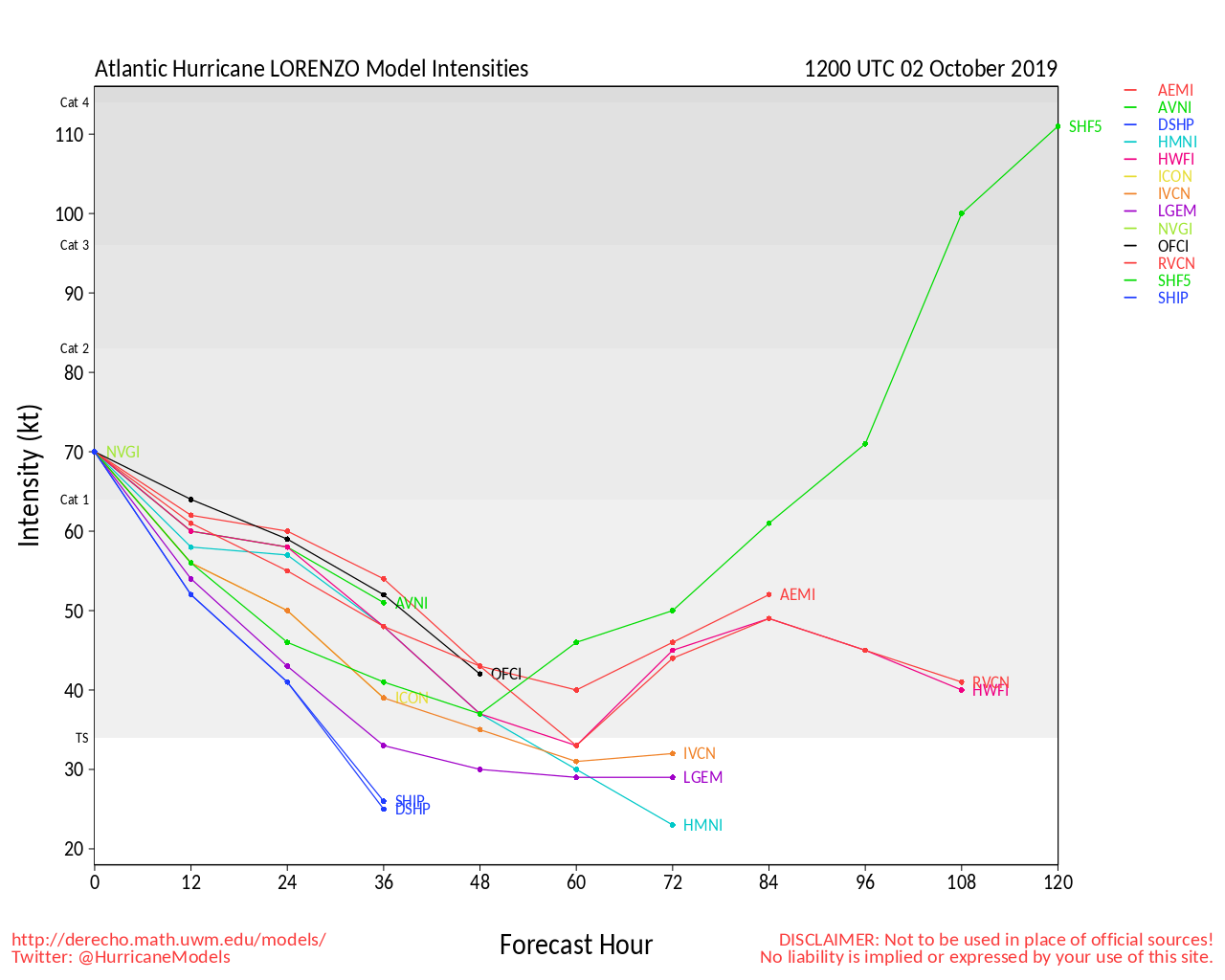
Lorenzo on the other hand is a category 3 hurricane in the open Atlantic, but it is staying out to sea. Although in the long term the Azores may want to watch it to see how close it gets.
No other areas are being really watched right now, as the Yucatan wave never really materialized. The general areas that are watched more closely into October are the Western Caribbean and Gulf, but neither has anything at the moment to watch now..
6:00 AM EDT Update 25 September 2019
Tropical Storm Karen is now north of the Caribbean and forecast to remain a Tropical storm over the next 5 days. The forecast takes it generally north or just east of north until Friday where the system slows down and does a clockwise loop before heading back to the west on the weekend. This is an unusual track, but the building ridge in the wake of now Post-Tropical Jerry should be enough to force it back west, and also likely weaken the system some due to shear. However, how much weakening is up in the air.
Beyond the 5 day track it is possible for Karen to get close to the Bahamas, and those in the Bahamas and even Florida should still watch. The ridge could be strong enough to push Karen fairly far south, although if it does the storm is likely to be very weak. The timing and how long Karen stalls before moving west are key things to watch for the long term impacts, as well as how strong (or weak) Karen is at the time. I'd expect the end of the forecast track to shift south and west over the next few days.
Bottom line Karen needs to be watched for Florida, but too soon to tell what impacts.it would have, if the storm is indeed moving west on Sunday we'll likely have a better general idea then. If it were to impact Florida it would likely be mid to late next week if it stays together as a system (it may dissipate once it moves further west).
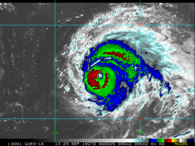
Hurricane Lorenzo is still moving west in the far east Atlantic, and forecast to become a major hurricane and recurve well out sea. Although the Azores still may want to keep watch to see how close Lorenzo manages to get later.
Additionally, the Yucatan area has a 20% chance to develop,
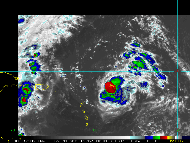
5:30 AM EDT Update 24 September 2019
Karen has regained Tropical Storm strength again overnight and is now forecast to be over the eastern side of Puerto Rico this afternoon and quickly move north of the Caribbean. Tropical Storm Warnings remain up for Puerto Rico and the Virgin Islands.
After this it is expected to move north or just east of north for most of the week before slowing down over the weekend then moving back to the west all while remaining a tropical storm. Beyond this things still are interestin gas the ridge that develops between Karen and Jerry is strong enough to push Karen westward which means Florida and the Bahamas will need to watch this system into the mid to later part of next week. As of now it looks like shear and dry air conditions will likely keep Karen on the weaker side, but intensity forecasting is very difficult.
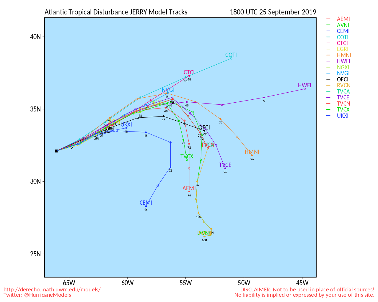
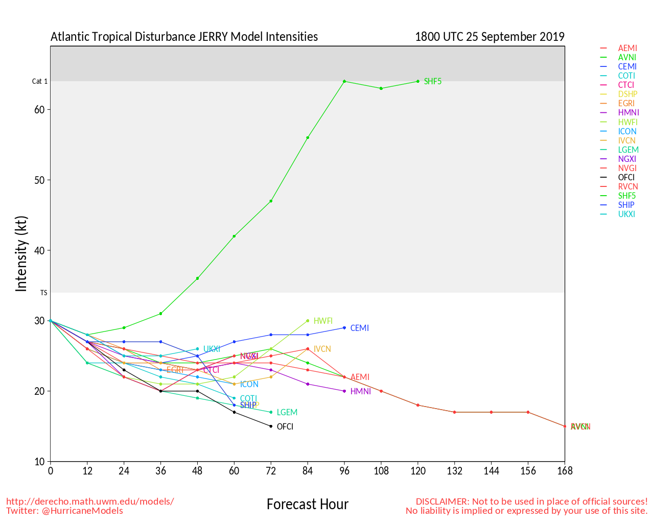
Jerry is also weak and moving near Bermuda as a tropical storm, it's closest approach to Bermuda will be tomorrow.
Lorenzo is a tropical storm in the far eastern Atlantic and is forecast to be a major hurricane, but not expected to affect any land areas.
There is also a low chance area for development near the Yucatan (20%) that is being watched.
7:30 AM EDT Update 23 September 2019
Tropical Storm Karen is very weak this morning and could even weaken to depression strength today in the East Caribbean. However there is now a Tropical Storm Warning up for Puerto Rico, Vieques, Culebra, and the U.S. Virgin Islands. And a watch for the British Virgin Islands as it nears the area. Assuming Karen survives conditions are better for development once north of the Caribbean.
Once beyond the Caribbean the Bahamas and Florida may want to watch this and the models suggest the ridge will be strong enough after Jerry moves out to push Karen toward the west toward Florida and the Bahamas, the forecast track shows the bend west at the end. .Plenty of time to watch, but Karen has a much higher chance to be forced west than any of the other recent systems.
Tropical Depression 13 formed in the east Atlantic off Africa. This one is expected to stay out to sea, but may near the Azores at some point.
Tropical Storm watches are up for Bermuda for Jerry as it is expected to pass enough north for only some of the impacts to be felt there, those in Bermuda should continue to watch it closely in case of changes.
Original Update
Tropical Storm Karen has formed near the southern windward islands in the Caribbean, * this one should be followed very closely over the next two weeks *. Because of the current position, Tropical Storm Warnings are up for Trinidad and Tobago, Grenada and its dependencies, St. Vincent and the Grenadines.
Tropical Storm watches are now up for Puerto Rico, the US and British Virgin Islands and also Vieques and Culebra.
Currently Karen is expected tor remain a tropical storm while in the Caribbean as it is somewhat disorganized and fighting shear, there is a potential for the system to fall apart completely if the shear intensifies too much.
If it survives, beyond the Caribbean, the track slows, and becomes very complex. after the 5 day time period of the official forecast, some of the more reliable models suggest the ridge builds back to the north which would drive Karen almost due west. So those in the Bahamas, Cuba, and Florida should monitor this over the coming week. If it does affect Cuba or Florida it would likely be around October 1st (give of take a few days). Plenty of time to watch to see if this hard left idea materializes or not and how strong Karen is at this time.
Tropical Storm Jerry is still a few days out, no watches are up for Bermuda at this time.
Outside of the two systems there in an area just off Africa that has a 90% chance for development.
As always, feel free to follow along with us in the Forecast Lounge, where we dive into a good deal of model talk. Active Lounges include:
Invest 96L Lounge , Jerry Lounge, Karen Lounge, Lorenzo Lounge
|
MikeC
Admin
Reged:
Posts: 4813
Loc: Orlando, FL
|
|
Watching the San Juan radar tonight (recording we made at http://flhurricane.com/imageanimator.php?506 ) makes me think the center may be trying to reform just Northwest of San Juan, shifting a bit to the west. Interesting little system to follow with Karen.
|
Robert
Weather Analyst

Reged:
Posts: 371
Loc: Southeast, FL
|
|
Yeah, i was thinking dead center on north coast, . Thinking the area northwest wraps under the big convection blob dead center.
A strong mesoscale vortex seems to be have wrapped full around counterclockwise a bigger gyre today, moved west then south, then east, and north and closed off and whacked Vieques, then west north west over purto rico, absorbed into the bigger gyre.
Not sure what 40 miles west will do to the end game if any at all, just puts it in better area to get captured by high pressure sooner and move the move west i suppose.
Edited by Robert (Tue Sep 24 2019 09:08 PM)
|
Robert
Weather Analyst
Reged:
Posts: 371
Loc: Southeast, FL
|
|
Jerry looks weaker then depicted in models, and i believe karen is under influence of the upper level low to her west, assuming, karen goes north, or ends up a hundred miles west of track tomorrow afternoon, running out the math in my head, would put karen a day or so ahead of the west turn, and put this weekend in the Bahamas.
Edited by Robert (Tue Sep 24 2019 09:43 PM)
|
MikeC
Admin
Reged:
Posts: 4813
Loc: Orlando, FL
|
|
It appears that Karen probably won't survive even another day at the rate it's going down.
|
Robert
Weather Analyst
Reged:
Posts: 371
Loc: Southeast, FL
|
|
Don't give up that easy.
Edited by Robert (Wed Sep 25 2019 08:11 PM)
|
Robert
Weather Analyst
Reged:
Posts: 371
Loc: Southeast, FL
|
|
Would appear the western center near 65.7 is more dominat and the eastern center being tracked is dying and being absorbed into the western center.
|
Robert
Weather Analyst
Reged:
Posts: 371
Loc: Southeast, FL
|
|
 https://www.nhc.noaa.gov/text/refresh/MIATCPAT2+shtml/262034.shtml https://www.nhc.noaa.gov/text/refresh/MIATCPAT2+shtml/262034.shtml
Edited by Robert (Thu Sep 26 2019 05:47 PM)
|
Robert
Weather Analyst
Reged:
Posts: 371
Loc: Southeast, FL
|
|
You mean the east side
|
Robert
Weather Analyst
Reged:
Posts: 371
Loc: Southeast, FL
|
|
And for whatever reason i cant upload because a screen shot of the same picture is over 5000000 
Edited by Robert (Thu Sep 26 2019 05:54 PM)
|


 Threaded


