F
Current Radar or Satellite Image

Flhurricane.com - Central Florida Hurricane Center - Tracking Storms since 1995Hurricanes Without the Hype! Since 1995


Chill falls over the Atlantic as the official season heads towards close
Days since last H. Landfall - US: Any 211 (Idalia) , Major: 211 (Idalia) Florida - Any: 211 (Idalia) Major: 211 (Idalia)
None
COMMUNICATION
STORM DATA
CONTENT
FOLLOW US
ADS
Login to remove ads


Archives 2020s >> 2020 News Talkbacks

Jump to first unread post. Pages: 1
MikeCAdministrator
Admin


Reged: Sun
Posts: 4542
Loc: Orlando, FL
The Preseason - TD1
      #100930 - Tue May 12 2020 01:05 PM

Tropical Depression One has formed northeast of the Bahamas, and tropical storm watches are now up from Surf City to Duck in North Carolina.


It's mid may, and although it is the official start of hurricane season in the East Pacific (may 15th) sometimes we get preseason systems in May in the Atlantic (which starts on June 1st).

A special tropical weather outlook was issued for a system that may begin forming late this week northeast of the Bahamas. Although it isn't expected to directly affect land areas, those in Bermuda may want to keep watch on it.


Tropical Depression One Event Related Links


float1latest.gif stormplotthumb_1.gif

SFWMD Model Plot (Animated Model Plot) SFWMD Hurricane Page


[https://flhurricane.com/floatanimator.php?year=2020&storm=1 Flhurricane Satellite Floater Animation of TD#1
GOES Floater
Animated Skeetobite Model Plot of TD#1


Clark Evans Track Model Plot of TD#1 (Animated!) Model Plots in Google Earth - In Google Maps
Clark Evans Intensity Model Plot of TD#1 (Animated!)

Clark Evans Track Plot of TD#1

Other Model Charts from Clark

Clark Evans Top 10 Analog Storms for TD#1
More model runs on from RAL/Jonathan Vigh's page
NRL Info on TD#1 -- RAMMB Info
COD Atlantic Satellite View


East Florida Links Southeast Composite Radar Loop (Latest Static) South to North:

Key West, FL Radar Radar Loop (Latest Static)

Miami, FL Radar Radar Loop (Latest Static)

Melbourne, FL Radar Radar Loop (Latest Static)

Jacksonville, FL Radar Radar Loop (Latest Static)


Caribbean/South East Coast Satellite Imagery


SFWMD Radar Loop of South Florida with storm Track


SFWMD Full Florida Radar Loop with Storm Track


Area Forecast Discussions: FLorida Keys - Miami/South Florida - Melbourne/East Central Florida - Jacksonville/Northeast Florida -
> Bahamas Media

Bahamas Radar

Television & Radio:

ZNS Bahamas, Radio & TV

More 94 FM Bahamas

Newspapers:

Bahamas Tribune

Nassau Guardian

Bahamas B2B

The Abaconian - Abaco Island News

Freeport News
Mid-Atlantic/Carolina Links Southeast Composite Radar Loop (Latest Static)

Charleston, SC Radar Radar Loop (Latest Static)

Wilmington, NC Radar Radar Loop (Latest Static)

Morehead City, NC Radar Radar Loop (Latest Static)

Norfolk/Wakefield, VA Radar Radar Loop (Latest Static)

Area Forecast Discussions: Charleston, SC - Wilmington, NC - Morehead City, NC - Norfolk/Virginia Beach/Hampton Roads, VA

Power Outage Maps: South Carolina Power Outage Map North Carolina Power Outage Map Virginia Power Outage Map


Invest 91L Event Related Links


float91latest.gif stormplotthumb_91.gif

SFWMD Model Plot (Animated Model Plot) SFWMD Hurricane Page


[https://flhurricane.com/floatanimator.php?year=2020&storm=91 Flhurricane Satellite Floater Animation of 91L
GOES Floater
Animated Skeetobite Model Plot of 91L


Clark Evans Track Model Plot of 91L (Animated!) Model Plots in Google Earth - In Google Maps
Clark Evans Intensity Model Plot of 91L (Animated!)

Clark Evans Track Plot of 91L

Other Model Charts from Clark

Clark Evans Top 10 Analog Storms for 91L
More model runs on from RAL/Jonathan Vigh's page
NRL Info on 91L -- RAMMB Info
COD Atlantic Satellite View


Post Extras: Print Post   Remind Me!   Notify Moderator  
MichaelA
Weather Analyst


Reged: Thu
Posts: 944
Loc: Pinellas Park, FL
Re: The Preseason [Re: MikeC]
      #100932 - Tue May 12 2020 04:58 PM

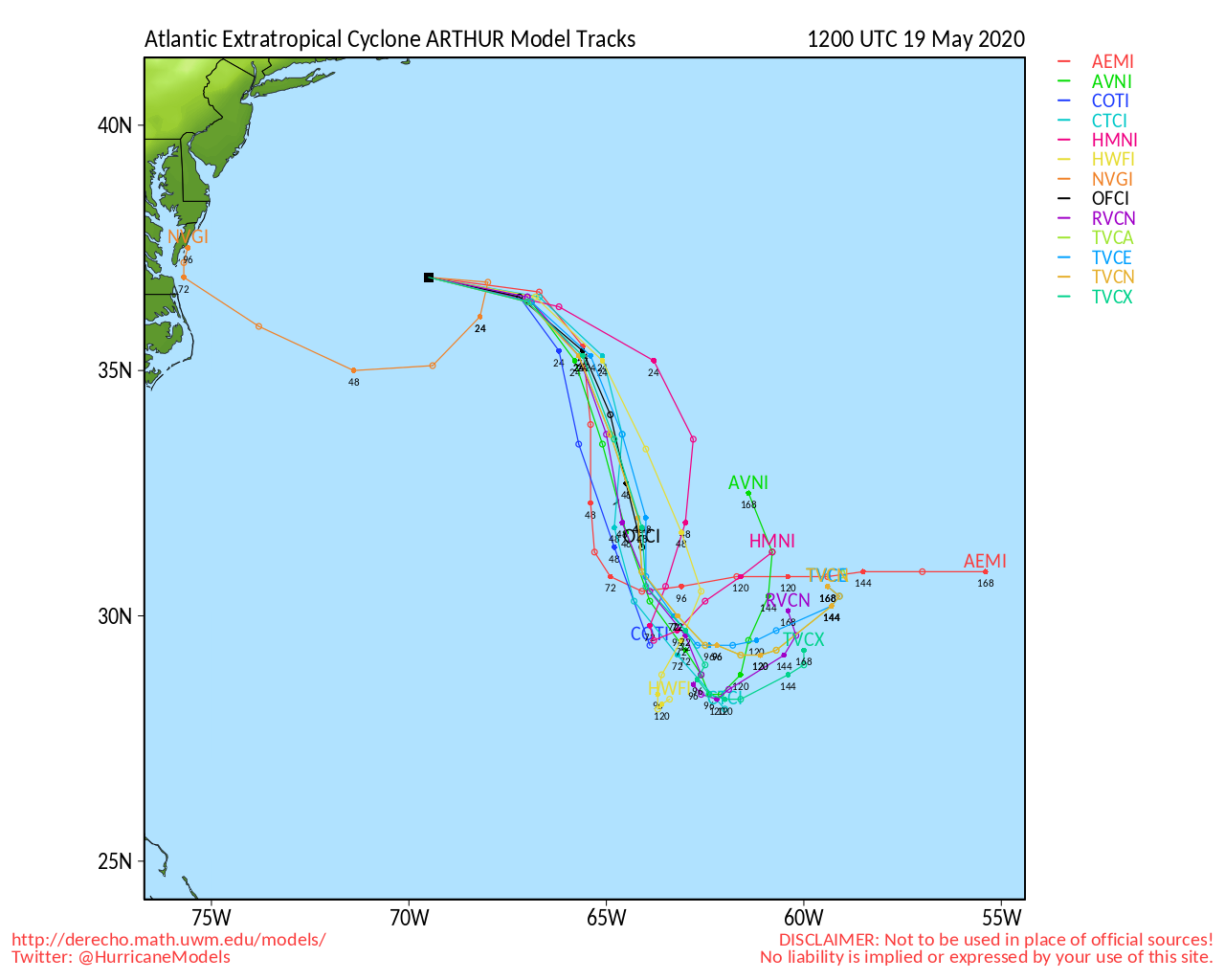
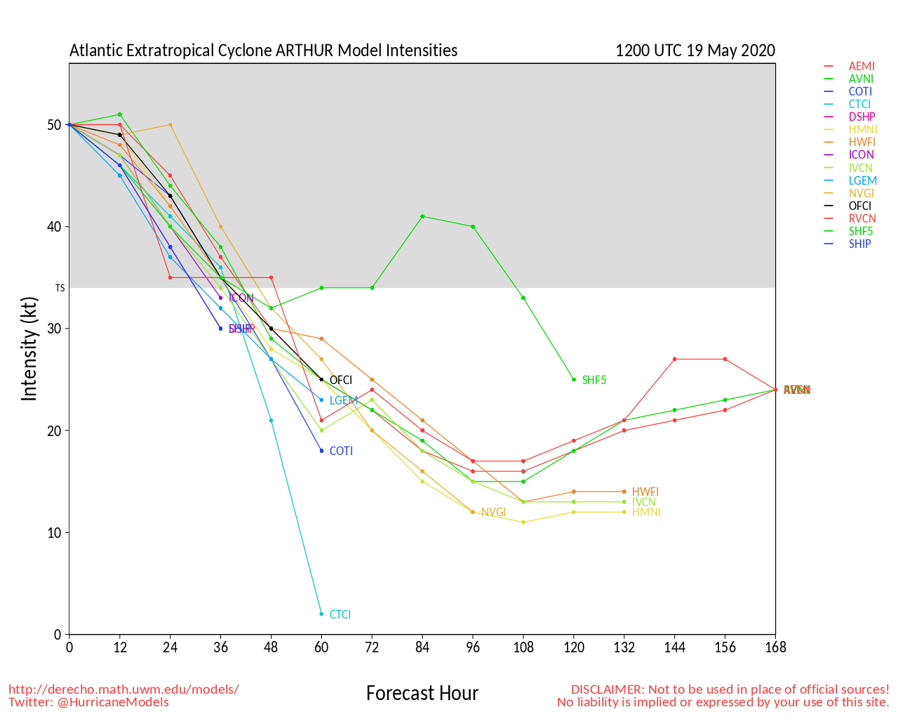
The FSU model page has all current model runs indicating development this coming weekend/early next week. Whether it is sub-tropical or purely tropical will remain to be seen.

I did see an article that stated that the East Pacific sea surface ENSO was beginning to cool which, if I recall correctly, could mean an above normal Atlantic season.

--------------------
Michael

PWS


Post Extras: Print Post   Remind Me!   Notify Moderator  
JMII
Weather Master


Reged: Thu
Posts: 489
Loc: Margate, Florida
Re: The Preseason [Re: MichaelA]
      #100943 - Fri May 15 2020 09:35 AM

Down here in S FL we need the rain, so no complaints with a tropical wave moving thru. Would just prefer it do this during the week and not the weekend however.

--------------------
South FL Native... experienced many tropical systems, put up the panels for:
David 79 - Floyd 87 - Andrew 92 - Georges 98 - Frances 04 - Wilma 05 - Matthew 16 - Irma 17
Lost our St James City rental property to Ian 22


Post Extras: Print Post   Remind Me!   Notify Moderator  
BloodstarModerator
Moderator


Reged: Mon
Posts: 462
Loc: Tucson, AZ
Well, here we go. [Re: JMII]
      #100947 - Sat May 16 2020 03:05 PM

Looks like first advisory will be at 5pm EDT.

Trivia: this will be the sixth year in a row that the Atlantic will have had a tropical system form before June first.

--------------------
M. S. Earth and Atmospheric Sciences, Georgia Tech - May 2020
Brookhaven National Laboratory
U. Arizona PhD Student


Post Extras: Print Post   Remind Me!   Notify Moderator  
IsoFlame
Weather Analyst


Reged: Wed
Posts: 295
Loc: One block off the Atlantic Oce...
Re: The Preseason - TD1 [Re: MikeC]
      #100957 - Wed May 27 2020 07:47 AM

Looking beyond Invest 91-L for any areas with "upstream" potential for development to our south early in the season, NWS Melbourne mentioned in extended discussion:

GFS guid continues to indicate modest onshore winds from the ATLC with a deepening Caribbean gyre centered near the Yucatan. EC is not quite into the height fall trend to the south.

--------------------
CoCoRaHS Weather Observer (FL-VL-42) & Surf Forecaster: https://www.surf-station.com/north-florida-surf-forecast-3/


Post Extras: Print Post   Remind Me!   Notify Moderator  
Pages: 1


Extra information
0 registered and 1 anonymous users are browsing this forum.

Moderator:  CFHC, Ed Dunham, Colleen A., Atricks, danielw, Clark, Christine H, RedingtonBeachGuy, SkeetoBite, Bloodstar, tpratch, typhoon_tip, cieldumort, Jackie M, Wigeon, Hank Buck 

Print Topic

Forum Permissions
      You cannot start new topics
      You cannot reply to topics
      HTML is disabled
      UBBCode is enabled

Rating:
Topic views: 14599

Rate this topic

Jump to

Note: This is NOT an official page. It is run by weather hobbyists and should not be used as a replacement for official sources. 
CFHC's main servers are currently located at
Hostdime.com in Orlando, FL.
Image Server Network thanks to Mike Potts and Amazon Web Services. If you have static file hosting space that allows dns aliasing contact us to help out! Some Maps Provided by:
Great thanks to all who donated and everyone who uses the site as well. Site designed for 800x600+ resolution
When in doubt, take the word of the National Hurricane Center