cieldumort
Moderator

Reged:
Posts: 2664
Loc: Austin, Tx
|
|
An approaching wave rolling off Africa is about to encounter an already convectively active belt of the Monsoon Trough way out in the central to eastern Tropical Atlantic and stay somewhat south, at least initially.
Given increasing model support for this wave to become a tropical cyclone that is suppressed to the south, we are starting a lounge on what could be yet another named CV type storm in just a few days, despite the strong El Niño.
This feature is not yet Invest tagged, but will likely be by the end of the week, and the title will be updated as warranted.
Invest tagged 90L on 9/21/23 and the title has been updated accordingly. TD-17 on 9/23/23 - Ciel
Edited by cieldumort (Wed Sep 27 2023 03:21 AM)
|
cieldumort
Moderator
Reged:
Posts: 2664
Loc: Austin, Tx
|
|
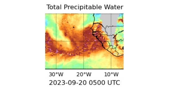
Above Total Precipitable Water (MIMIC-TPW2) of this wave, taken at 09/20/23/05z
"MIMIC-TPW2 is an experimental global product of total precipitable water (TPW), using morphological compositing of the MIRS retrieval from several available operational microwave-frequency sensors." ~ About the MIMIC-TPW2 product
The wave now just coming off the coast of west Africa continues to have model support for a southerly track, at least initially, with the increasingly most emphatic. However, now is probably a good time to mention that global model track runs beyond 7-10 days are often wildly unreliable, and the may also be displaying some southerly bias of late.
Caveats provided, here are some 0z runs from 9/20 as they come in up to 7 days out
Models at 7 days out from 09/20/0z
GFS: 974mb Hurricane just about 75 miles or so east of the Windward Islands, roughly along the same latitude as the southernmost Commonwealth of Dominica at 0z Wednesday Sep 27.
GEM: Nearly in the same location as the at this exact time, but only as a 1008mb open wave.
ICON: Lagging behind the and Canadian above, located around 15.5N 55.5W as a 1005mb Wave/TD/low-end TS.
|
cieldumort
Moderator
Reged:
Posts: 2664
Loc: Austin, Tx
|
|
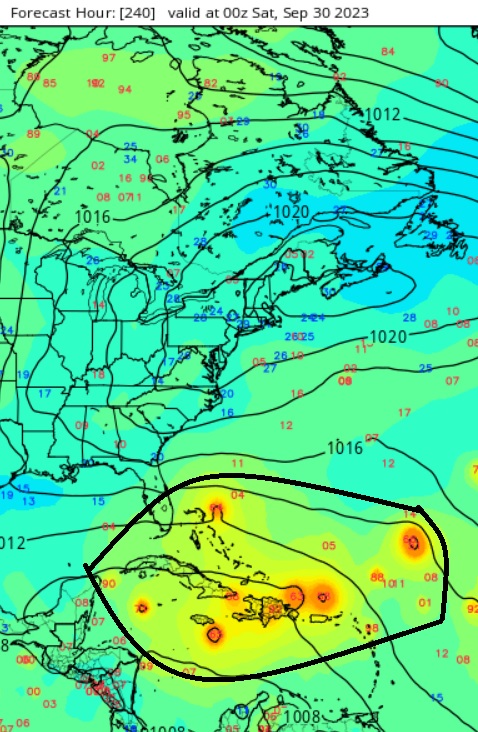
At ten days out a number of the individual ensemble members have developed this system, but there is a very large spread of intensities and locations as can be seen in this screenshot of the GEFS ensemble member heat map cr. Tropical Tidbits. I have outlined in black where most of the members are plotted at ten days out from the 9/20/0z runs.
|
cieldumort
Moderator
Reged:
Posts: 2664
Loc: Austin, Tx
|
|
Despite insistence from both the and that Philippe will essentially fall apart within 72 hours to become a post-tropical cyclone or remnant low, the system has shown some fight tonight, prompting to actually expand the region of tropical storm force winds in the northeast quadrant with the 11PM Advisory. Of particular interest however, is modeling that points to Philippe, or its remnant, coming back to life after a spell, and potentially posing some danger to the northern Caribbean islands.
A rundown of 09/27/0Z hurricane-centered model runs as follows:
HWRF - Strong Tropical Storm located about 75 miles north of Anguilla at the end of run (06Z Oct 2nd)
HMON - Strong Tropical Storm located less than 20 miles southeast of Barbuda at the end of run (06Z Oct 2nd)
HAFS-A Hurricane less than 15 miles northwest of Barbuda at 18Z Oct 1st, tracking just south of due west to end of run, still as a hurricane, at 06Z Oct 2nd.
HAFS-B Weakens to a blustery and wet open wave/TD/remnant low crossing through the northern Caribbean. 997mb wave/low centered just south of Hispaniola at the end of run (06z Oct 2nd).
As noted at the open, the and aren't having any of that, and wash the system out in short order with no coming back to life.
Time will tell with Philippe
|
cieldumort
Moderator
Reged:
Posts: 2664
Loc: Austin, Tx
|
|
|


 Threaded


