cieldumort
Moderator

Reged:
Posts: 2676
Loc: Austin, Tx
|
|
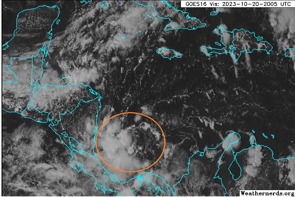
An area of low pressure has formed in the extreme southern Caribbean independent of the wave far out in the Atlantic that itself has been shown by several models to interact in this region's preexisting spin forecast for next week.
This feature has shown some signs of additional development today, and while largely expected by most models to run into central America, without significant development, there are some ways it could linger in the Caribbean quite a bit longer and/or become better organized. As such, we are starting a Lounge now on what is not yet Invest-tagged, but will likely be so soon if trends continue, and the title will be updated accordingly.
Interests in and around Central America may want to pay closer attention, for if nothing else, there is potential for very heavy rains and flooding in the region over the next few days.
Invest-tagged 95L at 1AM on Oct 22 and the title has been updated accordingly - Ciel
Edited by cieldumort (Mon Oct 23 2023 03:12 PM)
|
cieldumort
Moderator
Reged:
Posts: 2676
Loc: Austin, Tx
|
|
Like Tammy, this is another feature with some model runs indicating a propensity to stick around. In Tammy's case, there is already a well-formed tropical cyclone. In the case of this disturbance, this is a broad low already very land-locked and producing copious rains.
Should this Caribbean Low just linger, it may not matter one bit to those in central America whether it gets a name or not. The potential for persistent, heavy rains could make for a lot of flooding. Presently, it does not appear that the Low is getting much better organized this morning, but this could change as soon as later today. Next week, an approaching wave from the east (Wave Lounge) may interact with this system, developed or not, and further influence its prospects for development and track.
Some overviews of the 12Z model runs out today:
GFS: Tropical Depression or storm by Sunday night (0z Oct 23) in the extreme southwestern Caribbean while about 150 miles or so east of the Costa Rica/Nicaragua boarder. Landfall late Monday around the boarder of Costa Rica & Nicaragua, then slowly crosses over this landmass and enters the Pacific side of these nations by late Wednesday, continuing a potentially serious flood threat before becoming an East Pac TC and heading northwest on Thursday.
Canadian: Possibly a TD by Monday while just east of the Costa Rica/Nicaragua boarder. Slowly crosses central America (again, flood risks), and redevelops while just south of El Salvador on Wednesday or Thursday, becoming an E Pac system that heads northwest.
ICON: Never develops this beyond perhaps a TD and keeps it meandering about over the waters of extreme southern Caribbean, or just inland, for the next 180 hours (end of model run). Once more, potentially a flood maker.
While not seen in these particular 12Z runs out today, several earlier runs of these or other models indicated that the stout wave now approaching the Lesser Antilles interacts with this feature and spins up a TC in the central Caribbean, north of the disturbance's current location.
|
cieldumort
Moderator
Reged:
Posts: 2676
Loc: Austin, Tx
|
|
This tropical low is attempting to become a tropical cyclone, and will have opportunity to do so, so long as it stays over water.
|
cieldumort
Moderator
Reged:
Posts: 2676
Loc: Austin, Tx
|
|
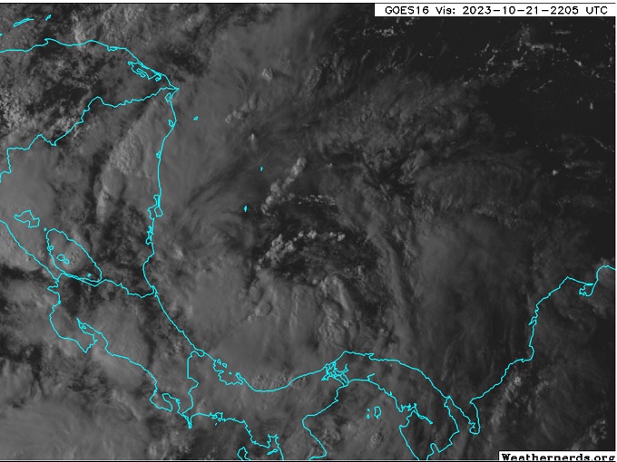
The Caribbean Low we have been tracking is now Invest 95L as of 1PM CDT Oct 22nd, with an initial position at 11.3N 81.4W and an intensity of 30 KTS.
Some 0z model summaries
GFS - Apparent TD or weak TS by tonight while roughly 120 miles east of southern Nicaragua with a landfall overnight Monday in northeastern Nicaragua as a modest tropical storm, then crawls northwestward while inland towards Belize, where it appears to wash out.
ICON - Seems to maintain the system as a weak low in the extreme southern-southwestern Caribbean, possibly at times crossing over to the East Pac side.
GEM - Apparent TD or weak TS by tonight while roughly 130 miles east of Reserva Biológica Indio MaÃz, Nicaragua, with a landfall Monday night as a modest tropical storm on central Nicaragua, then lingers over central America for several days as a decaying TC before merging with an East Pac system Friday.
|
cieldumort
Moderator
Reged:
Posts: 2676
Loc: Austin, Tx
|
|
This tropical low continues slowly developing and may already be a tropical cyclone, although it is not entirely clear given the dearth of sensors in this region, few Scatterometer passes and no recon. For all practical intents and purposes, the low should be treated as a 35-38 MPH TD, given that weather conditions are now basically the same.
Generally, models continue to linger 95L around Central America in some form or another. The longer it lingers, the greater the threats from flash flooding go up, as well as the greater the eventual possibility of the system being pulled up towards the US.
Some 12 Runs:
GFS - Borderline TD straddling in and out of Nicaragua for the next day or two before ending up in the East Pac, still moving slowly eventually northwest. Heavy rain maker for several days.
GEM - Generally like the in the first 48 hours, but then rather than heading further out into the EPAC, hugs the coastline for days on end, drenching Central America in rounds and rounds of tropical rains. By early next month, November 1st, this run plops 95L, or by then a named system, into the westernmost Caribbean as a remnant low or TD.
|
|


 Threaded


