cieldumort
Moderator

Reged:
Posts: 2721
Loc: Austin, Tx
|
|
A hybrid area of low pressure, a break-off from the non-tropical low traveling across the northern Gulf of Mexico, is packing quite a lot of punch tonight, and although conditions for transition into a more traditional (Nameable) sub-tropical, say nothing of tropical, storm are limited, this area of low pressure does possess some features often found in both non-tropical and tropical cyclones.
Given the intensity of the storm and proximity to land, we are starting a lounge on this feature now despite very low (10%) official odds of classification.
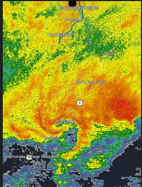
This developing low pressure system has already been producing sustained surface winds well into tropical storm force, and has something of an "eye-like" feature presently located over Key Largo. Models suggest that there is a slight chance that this could develop into something that resembles a hybrid hurricane as it tracks northeast along or nearly along the Gulf Stream, en route towards the coastal northeastern US, Canada, or out to sea.
This feature does not yet have an Invest tag, but could be assigned one, and the title will be updated accordingly as warranted.
|
TanukiMario
Registered User
Reged:
Posts: 7
|
|
Went to bed last night with the highest wind forecast at 27kts/32gusts and was woken up at 3am to 44knots sustained and a 52 knot gust on the anemometer on my boat (behind my house) and the power flickering.
Just came back in after doubling up some lines and adding more fenders, soaked to the bone and just a little annoyed, wondering who wet the bed on this forecast.
Morning news will be interesting, not to mention the posts on “Only in Dadeâ€
|
JMII
Weather Master

Reged:
Posts: 548
Loc: Cape Coral & Margate, FL
|
|
That was crazy. Here in Broward we experienced more wind and rain in 48 hours than the last several times there was a tropical storm warning from a “real†storm.
--------------------
South FL Native... experienced many tropical systems, put up the panels for:
David 79 - Floyd 87 - Andrew 92 - Georges 98 - Frances 04 - Wilma 05 - Matthew 16 - Irma 17
Lost our St James City rental property to Ian 22
|
IsoFlame
Weather Analyst

Reged:
Posts: 414
Loc: One block off the Atlantic Oce...
|
|
Models were spot on about the location of the hybrid spin-up, a bit off on intensity. Here in Daytona Beach Shores, had a windy night (east 25-35 mph) followed by a brief "lull" early this morning, then a ramp up once again this morning associated with shower bands streaming in off the Atlantic with wind E/ESE 30-40 mph (gusting to 40+). This morning's high tide was 2 feet above normal. Unsure of how bad dune erosion is where there is a dune because all we have here (in central coastal Volusia) are newly rebuilt sea walls and old concrete debris (leftover from last year's storms) where old sea walls weren't repaired.
--------------------
CoCoRaHS Weather Observer (FL-VL-42) & Surf Forecaster: https://www.surf-station.com/north-florida-surf-forecast-3/
|
IsoFlame
Weather Analyst
Reged:
Posts: 414
Loc: One block off the Atlantic Oce...
|
|
From my morning observation for CoCoRaHS station FL-VL-42:
7AM: 73F, CLOUDY, WIND NE 8 MPH. THE STRONG ONSHORE WIND OFF THE ATLANTIC HAS FINALLY RELAXED SOME THIS MORNING. MUCH OF THE 24-HR PRECIPITATION TOTAL OF 6.21 INCHES FELL BETWEEN 12:30-3:30 PM (NEARLY 3") AND BETWEEN 5:30-9:30 PM (2.5"). THE HIGHEST WIND GUSTS (IN EXCESS OF 40 MPH) FROM THE EAST WERE OBSERVED MID-MORNING BEFORE THE FIRST PERIOD OF HEAVY RAIN, THEN AGAIN IN THE EARLY EVENING DURING THE ONSET OF THE SECOND PERIOD OF HEAVY RAIN.
--------------------
CoCoRaHS Weather Observer (FL-VL-42) & Surf Forecaster: https://www.surf-station.com/north-florida-surf-forecast-3/
|
IdaliaJackson
Verified CFHC User

Reged:
Posts: 18
|
|
Season's OVER!
|


 Threaded


