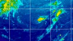
Current Radar or Satellite Image

Flhurricane.com - Central Florida Hurricane Center - Tracking Storms since 199531 Years of Hurricanes Without the Hype - Since 1995


Non-tropical Invest 94L well south of Bermuda slight odds of being named. EPAC TROF now extending across Central America into NW Caribbean.
Days since last Hurricane Landfall — US Any: 31 (Isaias), US Major: 761 (Milton), FL Any: 31 (Isaias), FL Major: 761 (Milton)
FlHurricane Atlantic Tropical Cyclone Tracking 🌀 Since 1995
HypeScale:
1.20
0510
Communication
Storm Data
Content
Follow & Connect
 
Show Selection:
Show plain - Location:
#1279301 (Received by flhurricane at: 10:54 AM 19.Sep.2026)
TCPAT1

BULLETIN
Tropical Depression Six Advisory Number 1
NWS National Hurricane Center Miami FL AL062026
300 PM GMT Sat Sep 19 2026

...NEW TROPICAL DEPRESSION FORMS SOUTHWEST OF THE AZORES...


SUMMARY OF 300 PM GMT...1500 UTC...INFORMATION
----------------------------------------------
LOCATION...32.6N 33.6W
ABOUT 525 MI...845 KM SW OF THE AZORES
MAXIMUM SUSTAINED WINDS...35 MPH...55 KM/H
PRESENT MOVEMENT...N OR 360 DEGREES AT 2 MPH...4 KM/H
MINIMUM CENTRAL PRESSURE...1009 MB...29.80 INCHES


WATCHES AND WARNINGS
--------------------
There are no coastal watches or warnings in effect.


DISCUSSION AND OUTLOOK
----------------------
At 300 PM GMT (1500 UTC), the center of Tropical Depression Six was
located near latitude 32.6 North, longitude 33.6 West. The
depression is moving toward the north near 2 mph (4 km/h). This
system is expected to generally move to the northeast for the next
24 to 36 hours, before turning toward the southwest in a couple of
days.

Maximum sustained winds are near 35 mph (55 km/h) with higher gusts.
Slight strengthening is possible during the next 24 hours, however
after that gradual weakening is expected to occur.

The estimated minimum central pressure is 1009 mb (29.80 inches).


HAZARDS AFFECTING LAND
----------------------
None


NEXT ADVISORY
-------------
Next complete advisory at 900 PM GMT.

$$
Forecaster Katz/Berg