Show Selection:
|
#1283106 (Received by flhurricane at: 4:51 PM 21.Oct.2026)
TCDAT5
Subtropical Storm Josephine Discussion Number 1
NWS National Hurricane Center Miami FL AL102026
500 PM AST Wed Oct 21 2026
The non-tropical area of low pressure (Invest AL93) that we have
been monitoring this week has acquired enough subtropical
characteristics to be considered a subtropical storm.
Scatterometer data showed that fronts near the cyclone had
dissipated, with a smaller radius-of-maximum wind than yesterday.
Additionally moderate-to-deep convection has been organizing near
and west of the warm-core center. Thus, advisories have been
initiated on a subtropical storm, and 55 kt is shown as the initial
intensity based on the scatterometer data.
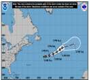
Josephine has been moving slowly northward today as a shortwave
ridge passes across the northeastern United States. The storm
should accelerate northeastward tomorrow as a mid-latitude trough
digs into the Great Lakes and Northeastern United States, taking
the system away from the US. By Friday, the low should turn
eastward, to the south of Newfoundland. Model guidance is in good
agreement on this path, and the new forecast is close to a blend of
the global model consensus and the NOAA corrected-consensus aid
HCCA.
The subtropical storm will likely intensify during the next day or
so through a favorable trough interaction while it remains near the
north wall of the Gulf Stream. Global models are in good agreement
on a band of hurricane-force winds developing tomorrow on the back
side of the low as it undergoes extratropical transition. A slow
weakening is anticipated by late Friday with the loss of forcing
from the trough while the system moves over cold water. The NHC
intensity forecast is similar to a blend of the GFS/ECMWF global
model solutions. The cyclone should become absorbed in about 4
days within a much larger low over the North Atlantic.
Since the coastal wind hazards with this system have been covered
for the last several days through non-tropical products issued by
local National Weather Service offices, and the system is forecast
to move away from the coast, those products will remain in effect
until the threat diminishes.
FORECAST POSITIONS AND MAX WINDS
INIT 21/2100Z 37.4N 69.5W 55 KT 65 MPH...SUBTROPICAL
12H 22/0600Z 38.1N 69.0W 60 KT 70 MPH...SUBTROPICAL
24H 22/1800Z 39.6N 66.2W 65 KT 75 MPH...POST-TROP/EXTRATROP
36H 23/0600Z 41.4N 61.6W 70 KT 80 MPH...POST-TROP/EXTRATROP
48H 23/1800Z 43.3N 56.9W 60 KT 70 MPH...POST-TROP/EXTRATROP
60H 24/0600Z 44.1N 53.5W 50 KT 60 MPH...POST-TROP/EXTRATROP
72H 24/1800Z 44.4N 50.4W 45 KT 50 MPH...POST-TROP/EXTRATROP
96H 25/1800Z 43.5N 37.5W 40 KT 45 MPH...POST-TROP/EXTRATROP
120H 26/1800Z...DISSIPATED
$$
Forecaster Blake |