Current Radar or Satellite Image

Flhurricane.com - Central Florida Hurricane Center - Tracking Storms since 199531 Years of Hurricanes Without the Hype - Since 1995


POLO HEADS FOR BAJA, NW MX, SW US. LARGEST MODERATE RISK FOR FLOODING EVER ISSUED IN SW US THIS WEEK. NOLO HEADS FOR NW HAWAII. HANNA FORMS.

Days since last Hurricane Landfall — US Any: 718 (Milton), US Major: 718 (Milton), FL Any: 718 (Milton), FL Major: 718 (Milton)
FlHurricane Atlantic Tropical Cyclone Tracking 🌀 Since 1995
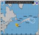
27.1N -44.6W
Wind: 35MPH
Pres: 1011mb
Moving:
Present movement...ssw or 210 degrees at 9 mph...15 km/h
Click for Storm Spotlight
36.6N -50.4W
Wind: 45MPH
Pres: 1006mb
Moving:
Present movement...e or 100 degrees at 17 mph...28 km/h
Click for Storm Spotlight
Invest 91LClick for Invest Information from CIMSS
HypeScale:
5.00
0510
Communication
Storm Data
Content
Follow & Connect
 

Flhurricane Animated Storm Model Plots for Tropical Depression Edouard (2026)
(source images from Levi Cowan's Tropical Tidbits)

59 images in loop. Last Checked: 11:01 am 05-Sep-2026 EDT. Last Updated: 02:12 pm 03-Sep-2026 EDT

Other animated plots: Flhurricane Throwback Spaghetti Plot - Clark Evan's Spaghetti Model - Clark Evans Intensity Model - Satellite Image

Updates checked for every hour, Actual changes depend on NHC/Models themselves.
XTRP is a line indicating the current direction of the storm, it is not a model.
TVCN is usually the best one to use on this page