danielw
Moderator

Reged:
Posts: 3527
Loc: Hattiesburg,MS (31.3N 89.3W)
|
|
Jeanne's remnants were located about 200 miles east of New York City,NY at 11:00AM EDT on September 29, 2004.
Maximum sustained winds re 25mph with higher gusts.
The remnants of Jeanne are moving E at 30mph, and forecast to move ENE over the Atlantic.
Damage along the coast from storm surge was greater this time than in , including our place in New Smyrna Beach which lost the beach walkway and about 8 feet of concrete walkway behind the seawall.
Lisa is located, at 5PM EDT-Wednesday, 1180 WSW of the Azores Islands. Moving N at 12mph. Maximum sustained winds are 70mph. Lisa is forecast to be absorbed by the remnants of Jeanne.
Lisa is already destined to be a fish spinner... so that leaves us with...
NOTHING! Hold a party... no storms currently. The season isn't over yet, but there is no discernable storm threats in the forseeable future.
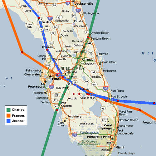
Skeetobite shows the paths of all three central Florida storms...

Event Related Links
You can find links to County Emergency Management offices at floridadisaster.org
Jeanne Color Satellite
Various Audio/Video Feeds from hurricane affected areas
Hurricane Local Statements for Weather Offices in:
All Current Hurricane Local Statements
Mark Sudduth is doing video updates as he heads toward Vero to set up his reasearch team. Check on it here.
Hurricanetrack HIRT vehicle (camera, and more)
Jeanne Models -- This image animated over time
Karl Models -- This image animated over time
Lisa Models -- This image animated over time
Jeanne Sphagehtti Model from BoatUS/Hurricane Alley
Jeanne Plots from Weather Underground
Jeanne Satelllite Image with track/radar Overlays
Jeanne Radar Image
Forecast Discussions for (Show All Locations):
Tampa. Miami, Key West, Jacksonville.
Melbourne
General Links
Skeetobite's storm track maps
Current Aircraft Recon Info (Decoded) thanks Londovir
Other Recon Info
NRL Monterey Marine Meteorology Division Forecast Track of Active Systems (Good Forecast Track Graphic and Satellite Photos)
Check the Storm Forum from time to time for comments on any new developing system.
Follow worldwide SST evolution here:
Global SST Animation
NASA GHCC Interactive Satellite images at:
North Atlantic Visible (Daytime Only), Infrared, Water Vapor
LSU Sat images
RAMSDIS Satellite Images (high speed)
Some forecast models:
NGM, AVN, MRF, ETA ECMWF
AVN, ,GFDL, JMA,NOGAPS,UKMET
DoD Weather Models (NOGAPS, AVN, MRF)
Multi-model plots from Mid-Atlantic Weather
Other commentary at Independentwx.com, Robert Lightbown/Crown Weather Tropical Update Accuweather's Joe Bastardi (now subcriber only unfortunately), Hurricane Alley North Atlantic Page, Hurricanetrack.com (Mark Sudduth), HurricaneVille, Cyclomax (Rich B.), Hurricane City , mpittweather , WXRisk, Gary Gray's Millennium Weather, storm2k, Barometer Bob's Hurricane Hollow, Snonut,
Even more on the links page.
|
danielw
Moderator
Reged:
Posts: 3527
Loc: Hattiesburg,MS (31.3N 89.3W)
|
|
TROPICAL WEATHER DISCUSSION
NWS TPC/NATIONAL HURRICANE CENTER MIAMI FL
805 PM EDT WED 29 SEP 2004
...DISCUSSION...
...GULF OF MEXICO...
COLD FRONT IS OVER THE CENTRAL GULF FROM ABOUT PENSACOLA SSW TO
28N90W INTO THE SW BAY OF CAMPECHE. THIS IS GENERALLY A DRY
FRONT WITH ONLY ISOLATED MODERATE IN THE SW GULF S OF 23N W OF
92W. FRONT ISN'T EXPECTED TO MAKE MUCH MORE PROGRESS DUE TO A
NE-SW ORIENTED MID/UPPER RIDGE FROM THE FLORIDA STRAITS TO THE
SW GULF. PATTERN IS SOMEWHAT STAGNANT WITH LITTLE CHANGE LIKELY.
CARIBBEAN SEA...
TSTMS KEEP FIRING IN THE SW CARIBBEAN ON THE DIVERGENT SIDE OF A BIG UPPER LOW S OF HISPANIOLA. WIDELY SCATTERED MODERATE S OF 14N W OF 79W WITH STRONG TSTMS NEAR THE COAST OF NW COLOMBIA.
DRY NE WINDS ARE OVER THE NW CARIBBEAN WITH GENERALLY QUIET WEATHER AND LOTS OF MID/UPPER SUBSIDENCE. HIGH CLOUDS OVER MOST OF THE E CARIBBEAN DUE TO TSTM BLOWOFF AND UPPER LIFT FROM THE UPPER LOW S OF HISPANIOLA ADVECTING THE MOISTURE EASTWARD TOWARD THE LESSER ANTILLES. THIS UPPER LOW IS ALSO PRODUCING LOTS OF RAIN WITH ISOLATED SHOWERS PRESENT N OF 16N E OF PUERTO RICO IN THE MOISTURE-RICH ENVIRONMENT. IN ADDITION..WIDELY SCATTERED SHOWERS ARE FROM 12N-17N BETWEEN 65W-71W. LOW WILL BE SPREADING LOCALLY HEAVY RAINS ACROSS HISPANIOLA TONIGHT INTO THE REST OF THE CENTRAL CARIBBEAN TOMORROW.
THE W CARIBBEAN MIGHT BE A PLACE TO WATCH FOR TROPICAL GENESIS WITH MODELS DEVELOPING UPPER RIDGING IN THE AREA BEHIND THE UPPER LOW MOVING THRU THE AREA OVER THE NEXT FEW DAYS.
|
sthorne
Weather Watcher

Reged:
Posts: 30
Loc: Port Saint Lucie, FL
|
|
Quote:
Lisa is already destined to be a fish spinner... so that leaves us with...
NOTHING! Hold a party... no storms currently. The season isn't over yet, but there is no discernable storm threats in the forseeable future.
...and there was much rejoicing (hooray!) Hurricane season is much better looked at from a distance.
Just got the phone/DSL line back today. We were without power for only 26 hours, we must be on a main line for sewer or water for Saint Lucie West. My mom in Vero has a transformer sitting in her backyard, and it's not a lovely lawn decoration. She's still out of power.
Of the refugees at our house, our friends from Fort Pierce who left thier Mobile Home lost their home, they will be staying with us while they wade through FEMA. The grandparents from Vero incurred no further damage, but they are still without power, so are staying with us. The relatives from around the corner fared well and have returned home.
1/2 of Saint Lucie County public schools are severley damaged, they have been out since Sept 2, no idea when or HOW they will open again. The private school my daughter attends suffered no significant damage and will open again when the power is restored.
That's about as quick an update as I can get in, lots to catch up on. Hope it's not a lot of repeating information.
|
MrSpock
Storm Tracker
Reged:
Posts: 296
|
|
I just heard from richisurfs, and after losing power for a couple of days, he is back up and running, and he and his family are ok. They were to the north of the track, but they have a well-built house, and came through it fine. He wanted me to let everyone know they were ok.
Is there anyone else we haven't heard from yet?
|
danielw
Moderator
Reged:
Posts: 3527
Loc: Hattiesburg,MS (31.3N 89.3W)
|
|
It's All good news.
|
SkeetoBite
Master of Maps

Reged:
Posts: 298
Loc: Lakeland, FL
|
|
Having an opportunity to watch 3 hurricanes up close, I noticed a pattern with the winds that I hope can be explained.
My perception is that while the winds are moving laterally at great speed, they also appear to be blowing downward. Most of the debris is lying close to its source. For example, we have a massive oak at the edge of the golf course behind our place. This tree lost a number of branches, large and small, which are ALL lying around the base of the tree.
Many of us have seen pictures of up to three different church steeples piercing the roof of the building right next to the peak of the roof. Seemingly an impossibility if the winds where not also blowing down with close to the same force.
A casual observer would expect debris to be carried great distances away as in a tornado, but this isn’t the case. Even the pictures of catastrophic damage show the debris from damaged or destroyed structures remains near by.
Any insight you can provide for us?
|
VandyBrad
Weather Hobbyist

Reged:
Posts: 80
Loc: Bryan, TX
|
|
I have no weather background what-so-ever but my first thought was "lift," or rather the opposite of it. We know that winds at higher altitude have higher velocity. Is it possible that these observations are a result of a lift effect working pushing the debris downwards?
--------------------
Brad Shumbera
|
danielw
Moderator
Reged:
Posts: 3527
Loc: Hattiesburg,MS (31.3N 89.3W)
|
|
While I haven't thought about the winds blowing downward theory, it does bear some serious thought.
I do know however that there has been research into the Hardwood species taking some of the "wind" out of hurricanes. Specifically the large friendship-type live oak trees. Many were stripped bare of their leaves in Camille and other storms here on the MS Gulf Coast. They lost a few limbs and branches, but no major damage. You may lookup Dr Chris Landsea at the Hurricane Research Division. His group has done extensive research into landfalling hurricanes, and may be of some assistance. Ricreig may be able to give you some info on Camille as he was stationed at Keesler AFB.
|
MrSpock
Storm Tracker
Reged:
Posts: 296
|
|
http://www.srh.noaa.gov/data/PHI/PNSPHI
This disc. goes into great detail about why the forecast track of Jeanne was off by 200 miles the other day, how it interacted with mid-lattitude systems, etc. Even though the storm track was off, the correctly note that the track was still inside the cone of uncertainty, and the lesson is, focus on the cone, not the dead center of it.
|
GuppieGrouper
Weather Master
Reged:
Posts: 596
Loc: Polk County, Florida
|
|
I too noticed the phenomenon, that nothing that was already on the ground was moved. We had a lot of yard trash waiting to be picked up and it was not blown around! However, much higher up on the roof and the trees were affected greatly. I think that the strewn debris is a key to studying how to make homes and landscapes "hurricane friendly"
--------------------
God commands. Laymen guess. Scientists record.
|
Ronn
User

Reged:
Posts: 115
Loc: Seminole, FL
|
|
Quote:
I too noticed the phenomenon, that nothing that was already on the ground was moved.
Surface winds in tropical cyclones are highest slightly above the surface due to friction at the earth's surface. This is why wind speeds are usually higher over open water, as opposed to land, because land has more friction than water.
On land, the maximum wind speeds usually reach the surface in the form of gusts, not sustained winds. This usually happens during downdrafts in rain squalls, which transport the higher winds above the surface to ground level. This might explain the downward force of wind on trees and buildings.
Meso-vortices, or mini-swirls, in the eye wall of hurricanes also can bring maximum wind speeds to the surface. Just like tornadoes, these vortices bring powerful winds right to ground level. This happened in Andrew, where we discovered narrow bands of catastrophic damage right next to areas with much less extreme damage. This is common in major hurricanes.
I am located about 4 miles inland from the Gulf Coast. When Jeanne passed just to my north this past weekend, I recorded wind gusts of 65mph in my neighborhood. However, just a 4 mile trip to the coast revealed a different situation. Winds right on the water were sustained at 60mph, and gusting to 75-80mph.
During Hurricane Jeanne, most areas slightly inland from the immediate coast likely did not see sustained winds near 120mph. These winds, and even gusts above 120mph, were realized mostly in the form of downdrafts and mini-swirls. Such wind distribution over land leads to the disparate levels of damage we see in areas struck by hurricanes.
Ronn
|
BillD
User
Reged:
Posts: 398
Loc: Miami
|
|
An updatd link for MrSpock's message above: PNSPHI.0409292003
They apparently archive the discussion each day for about a week, so don't delay reading it. Very interesting discussion.
Bill
|
tpratch
Moderator

Reged:
Posts: 341
Loc: Maryland
|
|
Quote:
Surface winds in tropical cyclones are highest slightly above the surface due to friction at the earth's surface. This is why wind speeds are usually higher over open water, as opposed to land, because land has more friction than water.
I don't think you mean friction.
Friction is the "force that resists the relative motion or tendency to such motion of two bodies in contact."
Wind gets slowed over land by the drag of objects on it (land, buildings, trees, et al). The resultant turbulence disrupts the "smooth" flow of the wind and causes it to dissipate energy.
Friction itself generally refers to solid objects - drag/lift refer to aerodynamic interactions.
Or else someone may have slipped crack into my Cheerios again 
|
VandyBrad
Weather Hobbyist
Reged:
Posts: 80
Loc: Bryan, TX
|
|
Quote:
I don't think you mean friction.
Friction is the "force that resists the relative motion or tendency to such motion of two bodies in contact."
Wind gets slowed over land by the drag of objects on it (land, buildings, trees, et al). The resultant turbulence disrupts the "smooth" flow of the wind and causes it to dissipate energy.
Friction itself generally refers to solid objects - drag/lift refer to aerodynamic interactions.
Or else someone may have slipped crack into my Cheerios again
I think you are correct on both accounts:
1) drag/lift are appropriate terms (I am afterall a chemical engineer), although drag could be a result of friction between the ground and molecules in the air... I guess the immediate difference is that friction dissipates the energy via heat loss while drag generates turbulence as you mentioned. This turbulence would become evident as mini-vortices like was mentioned previously!
2) someone did indeed slip crack into your Cheerios.
--------------------
Brad Shumbera
|
LI Phil
User

Reged:
Posts: 2637
Loc: Long Island (40.7N 73.6W)
|
|
The much needed break continues...
The tropics are quiet and look to be so through the weekend...thank you!
Do need to watch for some home brew but it seems the much needed break will last a few more days at least!
Cheers
LI Phil
--------------------
2005 Forecast: 14/7/4
BUCKLE UP!
"If your topic ain't tropic, your post will be toast"
|
Ed in Va
Weather Master
Reged:
Posts: 489
Loc:
|
|
Looks like it was a "Perect Front/Boundary/Dry Slot"! Wonder if anyone will make a book out of it.
--------------------
Survived Carol and Edna '54 in Maine. Guess this kind of dates me!
|
Terri
Weather Watcher

Reged:
Posts: 33
Loc: Richmond Hill, GA
|
|
Quote:
An updatd link for MrSpock's message above: PNSPHI.0409292003
They apparently archive the discussion each day for about a week, so don't delay reading it. Very interesting discussion.
Bill
Thank you, Bill and MrSpock.That is very interesting discussion, indeed! Seven inches of rain??? I was very fortunate on the GA coast. My rain was minuscule compared to those amounts.
|
tpratch
Moderator
Reged:
Posts: 341
Loc: Maryland
|
|
Quote:
The much needed break continues...
The tropics are quiet and look to be so through the weekend...thank you!
Do need to watch for some home brew but it seems the much needed break will last a few more days at least!
Cheers
LI Phil
I've been trying to rebuild my engine with a friend for 2 months now. Each and every weekend starting with , hurricane-related activities have taken precedence. This Sunday? First time since that he and I will be able to port the housings before getting them lapped. After that, we still have to assemble them.
$20 says that the last steps will be interrupted by a Hurricane (that's 2-3 weekends off). 
|
Ronn
User
Reged:
Posts: 115
Loc: Seminole, FL
|
|
Quote:
1) drag/lift are appropriate terms (I am afterall a chemical engineer), although drag could be a result of friction between the ground and molecules in the air... I guess the immediate difference is that friction dissipates the energy via heat loss while drag generates turbulence as you mentioned.
Actually, frictional drag is probably the most appropriate term. Essentially, what I was trying to say is that the greater friction over land slows the wind speed down. However, the higher wind speeds above the surface (where there is less friction) are brought down to the surface via downdrafts. Additionally, the meso-vortices I am talking about are not the result of drag, but moreso from eyewall dynamics. I am not an atmospheric scientist, so I very well may be incorrect. Here are some links.
Winds Near the Surface
Meso-Vortices in Bertha
God Bless,
Ronn
|
MrSpock
Storm Tracker
Reged:
Posts: 296
|
|
Thanks for updating that, I was unaware of the archiving.
|


 Threaded


