MikeC
Admin
Reged:
Posts: 4544
Loc: Orlando, FL
|
|
10:30AM CDT Update 9/13
Hurricane Ike began as a Tropical Wave emerging from Africa and was picked up as an "Invest" (97L) by the time it approached the Central Atlantic. As Hurricane Gustav was approaching Louisiana and Hanna the Bahamas, it formed into Tropical Depression 9. Later that same day, shortly after Gustav made landfall, TD#9 formed into Tropical Storm Ike.
Ike was beginning to be noticed in the Bahamas and Florida. The 's track took it through the Bahamas and was pointed dangerously close to South Florida. As it became apparent Hanna wasn't too much a threat to Florida, Ike was beginning to cause people to take interest in it.
As it approached the Bahamas, Ike started moving more southwestward, passing near Balfor Town in the Turks and Caicos Islands. From there, it continued to pile westward, moving over Inagua, the Flamingo habitat there, as well as Matthew Town and its large Morton Salt facility. These places experienced the full force of a Category 4 hurricane as Ike passed by. By then, it was then apparent it was not going to directly affect South Florida.
The forecast then turned toward Cuba, where it appeared it might ride up the spine of Cuba. Instead, it moved westward across Cuba and entered the Caribbean for a bit. Eventually turning northwestward and crossing the western tip of Cuba, this was enough to weaken the storm. After entering the Gulf, the hurricane-force wind radii greatly expanded and it appeared that South Texas might be under the gun. Storm tides across the Gulf from the Keys to the Florida Panhandle westward started to rise abnormally, a precursor to what lie ahead over the coming days.
As it entered the Central Gulf, it became more and more apparent that it would strike near or just south of Galveston. Ike had an odd eye structure for much of its time over the Gulf of Mexico, but it never really consolidated until very near landfall. Landfall came very early Saturday morning along Galveston Island itself. The surge at Galveston was just over 12 feet, with higher peaks, but not as bad as it could have been had the storm passed just west. It appears, at least for the downtown, the seawall was a good investment as it kept things from getting too bad there. But still vast amounts of damage happened, including the destruction of the historic Balinese room and the Galveston Memorial Monument to the infamous 1900 Hurricane. Port Bolivar, across the bay east of Galveston, had a 23 ft surge.
As it nears midday Saturday, Ike is moving rapidly northward, soon to merge with a cold front. A lot of the damage has yet to be assessed, and it appears the damage is very widespread. Tornadoes and heavy rainfall remain a significant threat with Ike for at least the next 24-36 hours.
8:30AM CDT Update 9/13
Ike made Landfall at Galveston at 2:10 AM CDT/3:10AM EDT
9:40PM CDT Update
Ike's likely last full advisory before landfall keeps it as a strong Category 2 storm, with the largest surge still to come in the next few hours. The center of Ike is 55 miles to the southeast of Galveston.
A convective burst in the Southwest side is showing that Ike is still trying to strengthen as it approaches.

7:00PM CDT Update
Ike has jogged a bit to the west northwest. Latest position estimate is 28.3N 94.0E. If this continues Ike will landfall just south of Galveston, which is probably the worst case for Galveston and Houston's coastal areas.
The eye is contracting a bit, so it appears likely that Ike will landfall as a Category 3 hurricane, with the equivalent of an upper Cat 4 (or even low 5) level storm surge because of the very broad high windfield.
Ike's worst should happen between Midnight and 1:30 in and around Galveston.
6:00PM CDT Update
At the 7PM Update Ike was located about 100 miles southeast of Galveston, moving northwest at 13MPH, Ike has strengthened to a maximum sustained windspeed of 110MPH, it sill has a chance to make landfall as a category 3.
Regardless the large surge will inundate a large coastal area later tonight.
Latest Coverage: houston Chronicle Hurricane Live blog - Multiple Affiliate TV Coverage to monitor most of the local coverage (Broadband only!).
1:30PM CDT Update
The National Hurricane Center's track seems to be right on, now. Recon has't totally confirmed it yet, but it appears Ike is trying to strengthen once again. The latest vortex message supports 110MPH winds, and it appears Ike may indeed be a proper Saffir-Simpson major hurricane before it makes landfall (As if the surge bubble didn't make it one).
Tidal Flooding continues all around the Northwest Gulf, including Galveston.
Let us know Ike conditions in your area here.
Hurricanetrack.com tower cam recording -- Visit Mark Sudduth and Mike Watkins over at hurricanetrack.com for more info.
If you want more real time information local sources are better, use this Multiple Affiliate TV Coverage to monitor most of the local coverage (Broadband only!).
Galveston Tidal Data
Original Update
Hurricane Ike strengthened a little overnight, now at 105MPH winds, it's still a very broad hurricane with a large area of hurricane force winds, and a massive storm surge.
Parts of the unwalled Galveston island are already seeing water rise.

The wave east of the Bahamas (91L) is not looking like it will develop but we will watch it over the next few days.
If you want more real time information local sources are better, use this Multiple Affiliate TV Coverage to monitor most of the local coverage (Broadband only!).
Mark Sudduth and my friend Mike Watkins are out in the HIRT team vehicle studying Hurricane Ike near Galveston, Visit and see the info at Hurricanetrack.com You can see where they are located now at our Ike Google Map
Let us know Ike Conditions in your area
Ike Microwave imagery (MIMIC) (More MIMIC)
Hurricane City Live Audio Stream
Upper Texas Coast Webcams (From Hurricane City)
Texas Emergency Management Reports
Southeastern US Radar Mosaic
Forecast Discussions for (Show All Locations):
Corpus Christi, TX, Houston/Galveston, Lake Charles, LA
New Orleans, LA
Brownsville, TX
Hurricane Ike Level 3 Radar Recording of Ike Approach
Ike Tides and Currents
Emergency Management:
Texas Division of Emergency Management
Entergy Texas Interactive Power Outage Map
Houston Traffic Cams
Texas/South Plains Radar Composite
Local Media/Television
Multiple Affiliate TV Coverage
KHOU the CBS affiliate in houston, is former Hurricane Center director Neil Frank's station, and likely will begin streaming once warnings are up in the area
Channel 2 NBC affiliate in Houston
ABC 13 in Houston
Houson Fox 26
Radio
KTRH Rado News/Talk station in Houston with streaming
Other Houston area radio
Galveston Police Scanner
Newspapers
Galveston Daily News
Houston Chronicle
Corpus Christi Caller-Times
Center Point Energy Houston area Power Outage Info
Color Sat of Gulf (Animation)
Cuba Mosaic radar recording of Ike Approach
Caribbean Islands Weather Reports
flhurricae Webcam recordings (will be turned on/off frequency adjusted as needed):
Spot Cam/Galveston Spot Beach Cam - Commodore Cam - Commodore Surf Cam/Galveston - Palacios Bay Cam
- Moody Gardens Recording
(Let us know if you know of other good views)
Moody Gardens Webcam
|
Random Chaos
Weather Analyst

Reged:
Posts: 1024
Loc: Maryland
|
|
In confirmation with SFMR readings, buoy 42361 (a Shell Oil rig) is measuring 99kt winds 50 miles NNE from the last center fix of Ike. Anemometer is at 122m above the surface, so this isn't really true surface winds.
All data: http://www.ndbc.noaa.gov/station_page.php?station=42361
Wind Graph: http://www.ndbc.noaa.gov/show_plot.php?s...;time_label=CDT
(didn't realize a new thread was created until after I originally posted this)
|
RedingtonBeachGuy
Moderator
Reged:
Posts: 342
Loc: St. Cloud, FL
|
|
CNN is showing water already over parts of the Galveston Seawall.
|
Raymond
Weather Guru
Reged:
Posts: 112
Loc: Germany
|
|
Nothing like an inner core left in Ike. The last microwave passes show all convective power in the E and especially concentrated in the SE. The former outer wall gets more an d more eroded in the W-NW. really a strange structure. The last changes may be due the by the mentioned increased northerly shear.

|
Humanriff
Verified CFHC User

Reged:
Posts: 24
Loc: Davenport, FL
|
|
Does anyone have a handle on the historical relative size of IKE? I live about half way between Lakeland and Orlando and was there for Jeanne in 04. It seemed like it went on forever. We actually had more damage to our house from Jeanne than from Charlie. I can't think of any real damage we had from Charlie even though the eye was about 15 miles away but Jeanne blew down our fence and stripped a bunch of shingles off the roof just because it lasted so long. It looks to me like this one is at least twice the diameter. Hopefully it will not get its act together any more than what is is now. We had far outer bands from Ike yesterday in Orlando. Unbelievable. Hope Galveston and Houston are ready. It's going to be a long weekend.
|
Thunderbird12
Meteorologist
Reged:
Posts: 644
Loc: Oklahoma
|
|
Based on flight-level winds and dropsondes, it looks like Ike may still be slowly increasing its max intensity. Whether or not this actually represents intensification of the system is debatable. In a large, broad circulation like Ike, changes in internal organization can bring the max winds up even if the system as a whole is not getting any stronger. There is a lot of wind energy that has the potential to be redistributed.
The character of the storm has not changed... it is still a very large system and the main threat will be the storm surge and a prolonged period of heavy wind, especially along and north of the track of the center. They always say to not focus too much on the exact forecast track line, but in Ike's case it is also important to not focus too much on what the max wind is or is not.
Ike looks like it might be trying to close off a large eye, but it is having trouble on the western side so far. The shear mainly seems to be impinging on the east side of the storm, but thus far it seems to be having little effect on the storm itself, since it is the west side that is struggling at the moment. If Ike does close off an eye, that would probably result in some modest deepening of the central pressure and increase in max winds, but time is running out.
|
berrywr
Weather Analyst

Reged:
Posts: 387
Loc: Opelika, AL
|
|
Conditions at 42361 as of
(9:00 am CDT)
1400 GMT on 09/12/2008:Unit of Measure: Time Zone:
Click on the graph icon in the table below to see a time series plot of the last five days of that observation.
Wind Direction (WDIR): NE ( 50 deg true )
Wind Speed (WSPD): 81.6 kts
Atmospheric Pressure (PRES): 28.58 in
Pressure Tendency (PTDY): -0.15 in ( Falling Rapidly )
Air Temperature (ATMP): 78.8 °F
Dew Point (DEWP): 77.0 °F
Heat Index (HEAT): 82.8 °F
Combined plot of Wind Speed, Gust, and Air Pressure
Previous observationsMM DD TIME
(CDT) WDIR WSPD
kts GST
kts WVHT
ft DPD
sec APD
sec MWD PRES
in PTDY
in ATMP
°F WTMP
°F DEWP
°F SAL
psu VIS
mi TIDE
ft
09 12 8:45 am NE 81.6 - - - - - 28.58 - 78.8 - 77.0 - - -
09 12 8:30 am NE 81.6 - - - - - 28.58 - 78.8 - 77.0 - - -
09 12 8:15 am NE 81.6 - - - - - 28.58 - 78.8 - 77.0 - - -
09 12 8:00 am NE 81.6 - - - - - 28.58 -0.32 78.8 - 77.0 - - -
09 12 7:45 am NE 87.4 - - - - - 28.55 - 78.8 - 77.0 - - -
09 12 7:30 am NE 99.1 - - - - - 28.58 - 78.8 - 75.2 - - -
09 12 7:00 am NE 99.1 - - - - - 28.63 -0.42 78.8 - 75.2 - - -
09 12 6:45 am NE 108.8 - - - - - 28.61 - 78.8 - 75.2 - - -
09 12 6:30 am NE 99.1 - - - - - 28.65 - 78.8 - 75.2 - - -
09 12 6:15 am NE 93.2 - - - - - 28.67 - 80.6 - 75.2 - - -
09 12 6:00 am NNE 93.2 - - - - - 28.73 -0.43 80.6 - 75.2 - - -
09 12 5:45 am NNE 95.2 - - - - - 28.76 - 80.6 - 75.2 - - -
09 12 5:30 am NNE 91.3 - - - - - 28.81 - 80.6 - 75.2 - - -
09 12 5:15 am NNE 91.3 - - - - - 28.83 - 80.6 - 75.2 - - -
09 12 5:00 am NNE 71.9 - - - - - 28.90 -0.32 78.8 - 75.2 - - -
09 12 4:45 am N 71.9 - - - - - 28.94 - 80.6 - 75.2 - - -
09 12 4:30 am NNE 81.6 - - - - - 28.98 - 80.6 - 73.4 - - -
09 12 4:15 am NNE 83.5 - - - - - 28.99 - 78.8 - 73.4 - - -
09 12 4:00 am NNE 79.6 - - - - - 29.05 -0.28 78.8 - 73.4 - - -
09 12 3:45 am N 56.3 - - - - - 29.07 - 78.8 - 75.2 - - -
09 12 3:30 am N 73.8 - - - - - 29.12 - 80.6 - 73.4 - - -
09 12 3:15 am NNE 73.8 - - - - - 29.13 - 80.6 - 73.4 - - -
09 12 3:00 am NNE 71.9 - - - - - 29.16 -0.24 80.6 - 73.4 - - -
09 12 2:45 am N 77.7 - - - - - 29.16 - 78.8 - 73.4 - - -
09 12 2:30 am N 69.9 - - - - - 29.20 - 78.8 - 73.4 - - -
09 12 2:15 am N 69.9 - - - - - 29.22 - 80.6 - 73.4 - - -
09 12 2:00 am NNE 77.7 - - - - - 29.22 -0.23 80.6 - 73.4 - - -
09 12 1:45 am NNE 64.1 - - - - - 29.27 - 80.6 - 73.4 - - -
09 12 1:30 am NNE 66.0 - - - - - 29.29 - 80.6 - 73.4 - - -
09 12 1:15 am NNE 69.9 - - - - - 29.31 - 80.6 - 73.4 - - -
09 12 1:00 am NNE 69.9 - - - - - 29.33 -0.17 82.4 - 73.4 - - -
09 12 12:45 am NNE 62.2 - - - - - 29.35 - 82.4 - 73.4 - - -
09 12 12:30 am NNE 62.2 - - - - - 29.37 - 82.4 - 73.4 - - -
09 12 12:15 am NNE 66.0 - - - - - 29.40 - 82.4 - 73.4 - - -
09 12 12:00 am N 66.0 - - - - - 29.40 -0.14 82.4 - 73.4 - - -
09 11 11:45 pm N 68.0 - - - - - 29.41 - 82.4 - 73.4 - - -
09 11 11:30 pm NNE 60.2 - - - - - 29.44 - 82.4 - 73.4 - - -
09 11 11:15 pm N 62.2 - - - - - 29.44 - 84.2 - 71.6 - - -
09 11 11:00 pm N 68.0 - - - - - 29.45 -0.10 84.2 - 71.6 - - -
09 11 10:45 pm N 58.3 - - - - - 29.47 - 84.2 - 71.6 - - -
09 11 10:30 pm NNE 62.2 - - - - - 29.48 - 84.2 - 71.6 - - -
09 11 10:15 pm N 60.2 - - - - - 29.49 - 84.2 - 71.6 - - -
09 11 10:00 pm N 54.4 - - - - - 29.50 -0.07 84.2 - 71.6 - - -
09 11 9:45 pm N 60.2 - - - - - 29.50 - 84.2 - 73.4 - - -
09 11 9:30 pm N 56.3 - - - - - 29.52 - 84.2 - 73.4 - - -
09 11 9:15 pm N 44.7 - - - - - 29.53 - 84.2 - 73.4 - - -
09 11 9:00 pm N 46.6 - - - - - 29.54 -0.06 84.2 - 75.2 - - -
09 11 8:45 pm NNE 36.9 - - - - - 29.54 - 84.2 - 75.2 - - -
09 11 8:30 pm NNE 42.7 - - - - - 29.54 - 84.2 - 73.4 - - -
09 11 8:15 pm NNE 44.7 - - - - - 29.55 - 84.2 - 73.4 - - -
09 11 8:00 pm NNE 38.9 - - - - - 29.55 -0.06 84.2 - 73.4 - - -
09 11 7:45 pm N 44.7 - - - - - 29.56 - 84.2 - 73.4 - - -
09 11 7:30 pm N 38.9 - - - - - 29.56 - 84.2 - 75.2 - - -
09 11 7:15 pm N 52.4 - - - - - 29.56 - 84.2 - 75.2 - - -
09 11 7:00 pm N 40.8 - - - - - 29.57 -0.06 84.2 - 75.2 - - -
09 11 6:45 pm N 42.7 - - - - - 29.58 - 84.2 - 73.4 - - -
09 11 6:30 pm N 42.7 - - - - - 29.59 - 84.2 - 73.4 - - -
09 11 6:15 pm N 38.9 - - - - - 29.59 - 84.2 - 75.2 - - -
09 11 6:00 pm NNE 36.9 - - - - - 29.60 -0.08 84.2 - 75.2 - - -
09 11 5:45 pm N 38.9 - - - - - 29.60 - 84.2 - 75.2 - - -
09 11 5:30 pm N 36.9 - - - - - 29.61 - 84.2 - 73.4 - - -
09 11 5:15 pm N 40.8 - - - - - 29.62 - 84.2 - 73.4 - - -
09 11 5:00 pm N 36.9 - - - - - 29.61 -0.09 86.0 - 75.2 - - -
09 11 4:45 pm N 46.6 - - - - - 29.62 - 86.0 - 73.4 - - -
09 11 4:30 pm N 44.7 - - - - - 29.62 - 86.0 - 73.4 - - -
09 11 4:15 pm NNE 42.7 - - - - - 29.63 - 86.0 - 73.4 - - -
09 11 4:00 pm N 42.7 - - - - - 29.63 -0.11 86.0 - 73.4 - - -
09 11 3:45 pm N 36.9 - - - - - 29.64 - 87.8 - 73.4 - - -
09 11 3:30 pm N 40.8 - - - - - 29.66 - 86.0 - 73.4 - - -
09 11 3:15 pm N 38.9 - - - - - 29.66 - 86.0 - 73.4 - - -
09 11 3:00 pm N 36.9 - - - - - 29.68 -0.08 86.0 - 75.2 - - -
09 11 2:45 pm N 31.1 - - - - - 29.68 - 86.0 - 75.2 - - -
09 11 2:30 pm N 35.0 - - - - - 29.69 - 86.0 - 73.4 - - -
09 11 2:15 pm N 27.2 - - - - - 29.70 - 87.8 - 73.4 - - -
09 11 2:00 pm N 36.9 - - - - - 29.70 -0.08 87.8 - 73.4 - - -
09 11 1:45 pm N 29.1 - - - - - 29.71 - 86.0 - 73.4 - - -
09 11 1:30 pm N 29.1 - - - - - 29.72 - 86.0 - 75.2 - - -
09 11 1:15 pm N 31.1 - - - - - 29.73 - 86.0 - 73.4 - - -
09 11 1:00 pm NNE 36.9 - - - - - 29.74 -0.05 84.2 - 73.4 - - -
09 11 12:45 pm N 29.1 - - - - - 29.75 - 84.2 - 75.2 - - -
09 11 12:30 pm N 31.1 - - - - - 29.75 - 87.8 - 73.4 - - -
09 11 12:15 pm N 31.1 - - - - - 29.76 - 87.8 - 73.4 - - -
09 11 12:00 pm N 31.1 - - - - - 29.76 -0.03 87.8 - 73.4 - - -
09 11 11:45 am NNE 31.1 - - - - - 29.77 - 87.8 - 73.4 - - -
09 11 11:30 am N 33.0 - - - - - 29.77 - 87.8 - 75.2 - - -
09 11 11:15 am N 29.1 - - - - - 29.78 - 87.8 - 75.2 - - -
09 11 11:00 am N 29.1 - - - - - 29.78 -0.01 87.8 - 73.4 - - -
09 11 10:45 am N 27.2 - - - - - 29.78 - 87.8 - 75.2 - - -
09 11 10:30 am NNE 35.0 - - - - - 29.78 - 86.0 - 73.4 - - -
09 11 10:15 am NNE 31.1 - - - - - 29.79 - 87.8 - 73.4 - - -
09 11 10:00 am NNE 35.0 - - - - - 29.79 +0.00 87.8 - 75.2 - - -
09 11 9:45 am NNE 35.0 - - - - - 29.78 - 86.0 - 73.4 - - -
09 11 9:30 am NNE 31.1 - - - - - 29.79 - 84.2 - 75.2 - - -
09 11 9:15 am N 31.1 - - - - - 29.79 - 84.2 - 75.2 - - -
09 11 9:00 am NNE 33.0 - - - - - 29.79 +0.01 84.2 - 73.4 - - -
--------------------
Sincerely,
Bill Berry
"Survived Trigonometry and Calculus I"
|
berrywr
Weather Analyst
Reged:
Posts: 387
Loc: Opelika, AL
|
|
The 7 am CT Public Advisory reported this buoy had 109 mph sustained wind at 400' elevation on the platform. My question, marine winds are reported in knots, not mph. Satellite presentation is the best I've seen Ike in a couple of days, despite northerly shear affecting it and does have what appears to be an eye and some cold, cold tops around it. Maybe the mets here might want to request verification whether these winds are in fact miles per hour or knots; if it is knot, it suggest Ike is in fact a Category 4 storm, though recent recon data refutes this data.
--------------------
Sincerely,
Bill Berry
"Survived Trigonometry and Calculus I"
|
berrywr
Weather Analyst
Reged:
Posts: 387
Loc: Opelika, AL
|
|
For the life of me I can't remember the name of that tropical storm that came off the Yucatan Peninsula and was by far the biggest tropical storm I've ever seen in the Gulf of Mexico, bigger than Ike; it encompassed almost the entire basin. I don't believe it ever became a hurricane because the inner core was so disupted that it never recovered. What is the name of that storm and what year?
--------------------
Sincerely,
Bill Berry
"Survived Trigonometry and Calculus I"
|
Thunderbird12
Meteorologist
Reged:
Posts: 644
Loc: Oklahoma
|
|
The winds from 42361 are measured at a height of 122 meters above the ground. They are not representative of winds near the ground (which are usuaully measured at 10 m). In a typical hurricane vertical wind profile, winds increase rapidly once you get immediately above the surface. This is why it is often said that high-rise buildings in the path of a hurricane will receive winds one category higher than what is observed at the surface.
The max winds reported at 42361 were 108.8 knots at around 6:45 AM CDT. I believe that would imply winds of about 90-95 knots at 10 m using the usual reduction.
|
tekkrite
Registered User
Reged:
Posts: 9
Loc: Melbourne, FL
|
|
With all the attention understandably on Ike, I don't see any commentary anywhere on 91L, the remnants of Josephine, which are now flaring up again east of the Bahamas. The 8:00AM model runs have suddenly converged on a path running up the east coast of Fla from West Palm to around the Cape. Do any of the mets care to comment on this disturbance (would it be Josephine or Kyle?)?
http://www.wunderground.com/tropical/tracking/at200891_model.html
Sorry for the off-topic post, but I doubted anyone would see it otherwise. A mod is welcome to start a new thread with it, of course.
Edited by tekkrite (Fri Sep 12 2008 02:52 PM)
|
MikeC
Admin
Reged:
Posts: 4544
Loc: Orlando, FL
|
|
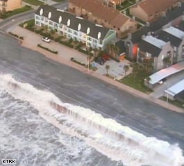
Anyone still on Galveston island is going to be in a world of hurt. This was the last good webcam Image I was able to get from downtown:

This location survived the 1900 storm, I hope it survives Ike.
|
clyde w.
Storm Tracker
Reged:
Posts: 211
Loc: Orlando, FL
|
|
Alaberry,
You may be thinking of Isidore in 2002. The storm came into the Gulf as a category 4, hooked left into the northern Yucatan Penninsula where it weakened to a strong Tropical Storm. It moved north and made landfall in Louisiana with 70 mph winds, but was incredibly broad as it moved through the Gulf. Ike has reminded me of a much stronger version of this storm on its trek through the Gulf.
|
madmumbler
Storm Tracker

Reged:
Posts: 324
Loc: SWFL
|
|
TWC is showing Surfside Beach, TX is basically underwater already from early surge. Mike Sidell's report stated that except for a few sections and the main road, water has overtaken the I'm assuming it's an island, and they'll be pulling out over the bridge to the mainland shortly.
--------------------
Lesli in SWFL.
Friends help you move. Real friends help you move bodies.
|
MichaelA
Weather Analyst

Reged:
Posts: 944
Loc: Pinellas Park, FL
|
|
I'm afraid that the major damage from Ike will be from the wide extent of the storm surge. With the center still well offshore, surge flooding has already begun from Louisiana to Galveston. A predicted 20 foot surge will easily breach the seawalls at Galveston and farther North at Port Arthur. This is going to be a devastating storm over a very large area.
--------------------
Michael
PWS
|
MikeC
Admin
Reged:
Posts: 4544
Loc: Orlando, FL
|
|
Quote:
I'm afraid that the major damage from Ike will be from the wide extent of the storm surge. With the center still well offshore, surge flooding has already begun from Louisiana to Galveston. A predicted 20 foot surge will easily breach the seawalls at Galveston and farther North at Port Arthur. This is going to be a devastating storm over a very large area.
Yes, Ike is more a surge engine than a traditional hurricane,

The for Ike is unreal, with even the ship canal near downtown Houston perhaps getting upwards of 20-27 feet of surge.
|
MichaelA
Weather Analyst
Reged:
Posts: 944
Loc: Pinellas Park, FL
|
|
Tides were 2 - 4 feet above normal along the West coast of FL yesterday on the back side and 400 miles from Ike's center. The entire GOM is being affected.
--------------------
Michael
PWS
|
Steve H1
Storm Tracker
Reged:
Posts: 309
Loc: Palm Bay FL USA
|
|
Hate to say this, but there are extremely cold cloud tops that are about to close a ring off around the core. This would seem to indicate that some strengthening is occurring, and we may see Cat 3 winds before this storm makes landfall. I wouildn't be surprised to see the eye clear out in the next couple of hours.....but I guess that's a moot point at this stage. Hope everyone gets out of the coastal areas.
|
Beaumont, TX
Storm Tracker
Reged:
Posts: 318
|
|
There is water in Sabine Pass. There is concern the surge could top the levees in Port Arthur. Mid-County residents were told to leave so my brother-in-law is "hunkering" down here. Surge is the biggest concern with this storm. West end of Galveston is under water.
|
Ed Dunham
Former Meteorologist & CFHC Forum Moderator (Ed Passed Away on May 14, 2017)
Reged:
Posts: 2565
Loc: Melbourne, FL
|
|
The weak center of Invest 91L was located yesterday near 22.1N 66.5W at 11/15Z. Today it is near 23.8N 70.9W at 12/17Z. Although the system continues to generate convection it is within a zone of windshear that is expected to increase, so development, if any, seems unlikely for awhile. The system is moving to the west northwest at 10 knots.
ED
|


 Threaded


