cieldumort
Moderator

Reged:
Posts: 2664
Loc: Austin, Tx
|
|
7:00PM EDT 02 September 2022 Update
Recon has found Invest 91L even more developed tonight and it is likely that will soon confirm that, while sheared, a bona fide Tropical Cyclone has formed, with advisories starting at any time. Interests in and around the Leewards Islands and the Greater Antilles may want to pay close attention to this system as it has trended a southerly track, could continue to do so if it misses its exit, and may already be a tropical storm. The next name on the list is Earl.
-Ciel
8:00AM EDT 02 September 2022 Update
Tropical Storm Danielle is well underway to becoming the first hurricane of the season, and likely will be upgraded to that within the next few hours. Danielle is expected to remain far away from land in the north Atlantic, and mostly a concern just for shipping.
The area east of the leeward islands sill has a 70% chance to develop over the next 5 days. But the system still remains too broad and elongated to be classified as a tropical depression or storm.
It likely will continue at this state for another day or so. A weaker system would imply a further west motion, however even then this system is still most likely to remain out to sea. A lot of that depends on how fast and strong the system does or does not get over the next week. Bermuda should continue to monitor it though.
In the east Atlantic chances for development seem to be dropping, and right now the official chances are 10% in the next 5 days.
10:30PM EDT 01 September 2022 Update
Recon investigating Invest 91L has found a somewhat more defined center with believable SFMR winds just under tropical storm force, a minimum central pressure of about 1005-1006mb, and it would seem this system is on the cusp. Considering that it is not coming together as rapidly as many models forecast and thus hugging more of the southern route still, Potential Tropical Cyclone advisories at the very least may be coming by morning, as it now stands to at least brush some of the Antilles. Also, even just a small increase in organization from here would qualify the system as a bona fide tropical cyclone.
-Ciel
4PM EDT 01 September 2022 Update
Tropical Storm Danielle has formed in the North Atlantic, and is strengthening rapidly, and could be a hurricane possibly later tonight or tomorrow. It is staying out to sea.
4AM EDT 01 September 2022 Update
Five has formed in the Atlantic, although it might not be the system most people have been talking about. Invest 93L has become a stout cyclone and likely to become quite strong well out at sea in the North Central Atlantic, and advisories are going to begin shortly. We have a Lounge up on the cyclone given the potential for it to impact the Azores and/or western Europe, otherwise mostly a fish spinner. Five Lounge
-Ciel
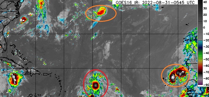
8AM EDT 31 August 2022 Update
3 Areas are being watched today, and it's likely we'll officially close off August without a named storm in the Atlantic. 93L may give a run for it, though.
The first east of the Caribbean islands (91L) still has an 80% chance to develop over the next 5 days. This area is still large and elongated and is taking quite a while to get together, convection from overnight has waned this morning, but there are signs of at least a fairly decent mid level center. It is expected to slowly over the next few day. Longer term, most likely based on model ensembles, this system will stay away from the Bahamas and US, but should be monitored just in unlikely case the slow forward motion causes things to shift later on. Bermuda should watch the closest, however.
The second is an area in the Subtropics further north in the Atlantic (Now Invest 93L), this is in a good spot for development, and chances are up to 70% for the next 5 days. It's moving east away from US land, it could impact the Azores and even Europe down the road, though.
The area in the east Atlantic is likely to have some impacts on the Cape/Cabo Verde islands. It has a 50% chance to develop. Beyond the Cabo/Cape Verde islands, it's likely to feel the impact from the other systems and get dragged out to sea also.
Base map cr. Weathernerds.org
2AM EDT 31 August 2022 Update
Conditions for hurricane development in the Main Development Region of the Atlantic are classically favorable now, with a few caveats: some residual subdued instability, dry air and also, interestingly, excessive horizontal vorticity in the MDR. These are a few items on the ponderables list for tropical cyclone experts this highly unusual season to try to tease out why it has seemingly defied forecasts. Caveats aside, the basin is clearly perking up, and it would not take much to see one, two or perhaps even more named storms this week as the month of August comes to a close and September begins.
Invest 91L is still elongated, lacking a well-defined center, but convection is firing and consolidating, and it appears that it is starting to get it together. It is looking likely that this will be become a T.D. or named storm today or tomorrow, and has a real shot of becoming not just this season's first hurricane, but also first major hurricane. The question then that every wants to know is, where will it go. Once we have a coherent system (bona fide tropical cyclone), models should become more reliable as to its track. Early runs suggest a recurvature well away from the U.S., but where it ultimately heads is going to depend a good deal on where a well-defined center has finally formed. The next name on the list in 2022 is Danielle.
Elsewhere, a vigorous tropical wave in the far eastern Atlantic could become a T.D. or named storm and bring inclement weather to the Cabo Verde Islands this week, regardless of classification. In the sub-tropical Atlantic, development looks plausible along a decaying frontal zone, and this may also get named this week. Should it develop, it may impact the Azores by week's end.
Ciel
8PM EDT 30 August 2022 Update
Three areas this evening being watched, the newest is an area in the Central Subtropical Atlantic with a 30% chance to develop. The Red area (Invest 91L) is at 60% in the next 48 hours and 80% in the next 5 days, and is starting to organize more. It's still most likely to avoid the Caribbean islands to the north and stay out to sea, but should be watched in case anything changes, especially in Bermuda. The last area in the east Atlantic has a 40% chance to Develop, those in the Cabo/Cape Verde islands should keep watch.
8PM EDT 28 August 2022 Update
4 Areas being tracked right now, the area in the Northwestern Caribbean only has a 20% chance to develop, if it does it would likely be on Wednesday or Thursday. Those in the Yucatan Peninsula should keep watch in case it does decide to develop. It has very little model support (save one).
The Red area is now up to 70% chance to develop over the next 5 days, and 50% chance to develop in the next 48 hours. It is likely to become a depression or storm sometime this week, as it nears the Leeward islands. Those in those islands should watch closely, but it is likely to stay to the north. Beyond that the Bahamas will want to keep watch and the Southeast US coast, for probably labor day week. Although most of the long range ensembles keep it offshore, there is a point where steering may change later in next week that could bring it much closer to the coast. In short, way too soon to tell, so it's best to monitor this particular area over the next week or two.
Another area in the East Atlantic has a 20% chance to develop in the next 5 days, and a small area east of Bermuda only has a 10% chance to develop.
8PM EDT 27 August 2022 Update
Conditions for development continue to improve and as of tonight has also added the well-defined Low centered about 600 miles east of Bermuda we noted earlier in the original entry to their evening Tropical Weather Outlook, and it now seems more likely than not there will be at least one or two Invest-tagged features by early next week.
The well-defined Low east of Bermuda would probably only have to sustain deep convection for a while to get named, but fortunately it should stay well out at sea and at the moment is also contending with some stout shear at any rate. For those residing in the western Atlantic, the two main players of interest at this time are the large, sprawly area of low pressure in the central Atlantic, and the genesis forecast by next week in the western Caribbean.
Ciel
Original Update
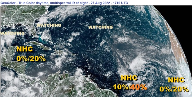
We've already had a number of lemons this year, plus a few oranges that barely got their act together at the very last moment. But now we see a couple of systems far enough out that while still officially "code yellow" or maybe even a bit of "code orange," could possibly be something other than yet another long-range bust. Bananas!
Speaking of bananas, it is fairly common for tropical cyclones to form in clusters, ripening one after another or even at about the same time. As of Saturday August 27, there are three main features being monitored by for potential development within the 2-5 day window. One coming up from the central Caribbean heading west-northwest, one east of the Caribbean in the central Atlantic, and a third about to exit the west coast of Africa into the far eastern Atlantic. In addition, there are a couple of other areas that while not mentioned yet in the , are worth keeping an eye on, especially given how this year has seen more systems pop close to home and at the last minute than out at sea even with hearty model support to do so.
As the system in the central Atlantic has held its own for a few days despite less-than-ideal conditions, and it does have general model support, a Forecast Lounge is now up on this feature open for discussion and model talk here 91L Forecast Lounge
Ciel
Edited by MikeC (Fri Sep 02 2022 10:23 PM)
|
cieldumort
Moderator
Reged:
Posts: 2664
Loc: Austin, Tx
|
|
Product: NOAA Vortex Message (URNT12 KWBC)
Transmitted: 2nd day of the month at 23:13Z
Agency: National Oceanic and Atmospheric Administration (NOAA)
Aircraft: Lockheed WP-3D Orion (Reg. Num. N43RF)
Mission Purpose: Investigate $config{get_number_word_from_suspect_area}{$storm_number} suspect area}
Storm Name: $name (Note: the storm number was labeled as a suspect area) (flight in the North Atlantic basin)
Mission Number: 4
Observation Number: 10
A. Time of Center Fix: 2nd day of the month at 22:27:53Z
B. Center Fix Coordinates: 17.87N 59.26W
B. Center Fix Location: 178 statute miles (287 km) to the ENE (73°) from Saint John's, Antigua and Barbuda.
C. Minimum Height at Standard Level: 3,136m (10,289ft) at 700mb
D. Minimum Sea Level Pressure: 1007mb (29.74 inHg)
E. Dropsonde Surface Wind at Center: From 220° at 10kts (From the SW at 12mph)
F. Eye Character: Not Available
G. Eye Shape: Not Available
H. Estimated (by SFMR or visually) Maximum Surface Wind Inbound: 12kts (13.8mph)
I. Location & Time of the Estimated Maximum Surface Wind Inbound: 52 nautical miles (60 statute miles) to the W (273°) of center fix at 22:14:38Z
J. Maximum Flight Level Wind Inbound: From 27° at 17kts (From the NNE at 19.6mph)
K. Location & Time of the Maximum Flight Level Wind Inbound: 55 nautical miles (63 statute miles) to the W (272°) of center fix at 22:13:48Z
L. Estimated (by SFMR or visually) Maximum Surface Wind Outbound: 38kts (43.7mph)
M. Location & Time of the Estimated Maximum Surface Wind Outbound: 47 nautical miles (54 statute miles) to the E (93°) of center fix at 22:39:02Z
N. Maximum Flight Level Wind Outbound: From 147° at 44kts (From the SSE at 50.6mph)
O. Location & Time of the Maximum Flight Level Wind Outbound: 130 nautical miles (150 statute miles) to the E (91°) of center fix at 22:58:44Z
P. Maximum Flight Level Temp & Pressure Altitude Outside Eye: 12°C (54°F) at a pressure alt. of 2,872m (9,423ft)
Q. Maximum Flight Level Temp & Pressure Altitude Inside Eye: 12°C (54°F) at a pressure alt. of 2,873m (9,426ft)
R. Dewpoint Temp (collected at same location as temp inside eye): 8°C (46°F)
R. Sea Surface Temp (collected at same location as temp inside eye): Not Available
S. Fix Determined By: Penetration, Wind and Pressure
S. Fix Level: 700mb
T. Navigational Fix Accuracy: 0.01 nautical miles
T. Meteorological Accuracy: 5 nautical miles
Remarks Section:
Maximum Flight Level Wind: 44kts (~ 50.6mph) which was observed 130 nautical miles (150 statute miles) to the E (91°) from the flight level center at 22:58:44Z
Maximum Flight Level Temp: 12°C (54°F) which was observed 47 nautical miles (54 statute miles) to the W (273°) from the flight level center
|
|


 Threaded


