Wet weekend and next weekend, but tropical development very unlikely.
Days since last Hurricane Landfall —
US Any:
598 (Milton),
US Major:
598 (Milton),
FL Any:
598 (Milton),
FL Major:
598 (Milton)
cieldumort
Moderator

Reged:
Posts: 2666
Loc: Austin, Tx
|
|
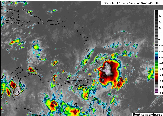
A small but robust tropical wave centered a few hundred miles east-southeast of the Lesser Antilles has been showing increasing signs of organization. This feature has just been Invest tagged 90L, and despite low initial odds for development (0%/30%), this feature may surprise on the upside.
While models are flickering warm/cool on this feature, conditions for development across the Caribbean (including the "Graveyard" eastern Caribbean) are actually quite anomalously favorable. The operational Tropical Cyclone Formation Probability Product shows the Caribbean overall to be running more than twice as conducive for development as normal this time of year, with the bulk of that coming from the eastern Caribbean - with that favorable swath also edging well into the Main Development Region east of the Lesser Antilles.
Given 90L's close proximity to land, the fact that the Invest will soon be landlocked, and the anomalously favorable environment it finds itself in, we are starting a Lounge on this Invest at this time.
Small disturbances often don't make it, but those that do, often overperform.
Track is presently W-WNW at 10 to 15 mph. Should 90L develop and intensify, as is possible, a more poleward track may commence.
Invest 90L has been upgraded to Tropical Storm Franklin at 5PM 8/20 and the title is updated accordingly. - Ciel
Edited by cieldumort (Sun Aug 20 2023 04:43 PM)
|
cieldumort
Moderator
Reged:
Posts: 2666
Loc: Austin, Tx
|
|

90L is on the cusp tonight and appears likely to begin tracking poleward as a strengthening tropical cyclone.
Some 20/0z model runs:
20/0z turns 90L north as a strengthening TC, taking it across the Dominican Republic as a 992mb 50KT tropical storm. After crossing the island the has the cyclone undergo further intensification, becoming a strong Cat 1/2 hurricane traveling north-northwest towards Bermuda and then crossing the island nation from the southeast overnight Saturday Aug 26th as a Cat 2 hurricane
20/0z HWRF Threads the needle in between between the passage of the Dominican Republic and Puerto Rico overnight Tuesday Aug 22nd as a strong Cat 1, then proceeds north-northeast bringing the cyclone to Major Hurricane by 25/0z, winding down as it tracks north-northeast away from land.
20/0z HMON Drives 90L into the DR overnight on the 22nd as a 995mb 50KT tropical storm. Once having crossed that island, HMON never really revs it up much, opting instead to keep it a sloppy tropical storm/eventual hybrid, tracking north-northeast away from land.
20/0z HAFSA Strengthens 90L into a strong storm or perhaps Cat 1 while south of DR/PR on Monday the 21st, then takes the cyclone over the DR on Tuesday 22nd. End of run near 26.5N 64.5W while tracking north-northeast at Cat 1 and back up to Cat 1 after having weakened over DR.
|
IsoFlame
Weather Analyst

Reged:
Posts: 412
Loc: One block off the Atlantic Oce...
|
|
I'm not on board with the weak assessment of Franklin after re-emergence today (Weds 8.23/23). Regardless of the jog over DR, the circulation remains intact and environmental conditions over the SW Atlantic are very conducive to re-intensification (even rapid over the weekend). It would not be a surprise to me if Franklin becomes a strong 2 well east of Florida on Sunday- then a borderline Major on track toward Bermuda early next week.
--------------------
CoCoRaHS Weather Observer (FL-VL-42) & Surf Forecaster: https://www.surf-station.com/north-florida-surf-forecast-3/
|
IsoFlame
Weather Analyst
Reged:
Posts: 412
Loc: One block off the Atlantic Oce...
|
|
At noon on Friday NW'erly shear had the LLC completely exposed, dislocated 150 miles away from deep convection to the southeast .
--------------------
CoCoRaHS Weather Observer (FL-VL-42) & Surf Forecaster: https://www.surf-station.com/north-florida-surf-forecast-3/
|
|
0 registered and 2 anonymous users are browsing this forum.
Moderator:
Print Topic
|
Forum Permissions
You cannot start new topics
You cannot reply to topics
HTML is disabled
UBBCode is enabled
|
Rating:
Topic views: 2954
|
|
|
|
|
|
Note: This is
NOT an official page. It is run by weather hobbyists and should not be used as a replacement for official sources.
CFHC's main servers are currently located at
Hostdime.com in Orlando, FL.
Image Server Network thanks to Mike Potts and Amazon Web Services. If you have static file hosting space that allows dns aliasing contact us to help out! Some Maps Provided by:
Great thanks to all who
donated and everyone who uses the site as well.
Site designed for 800x600+ resolution
When in doubt, take the word of the
National Hurricane Center


 Threaded


