
Latest CFHC News
- See More News...
Dr Phil Klotzbach has released the Colorado state university numbers.
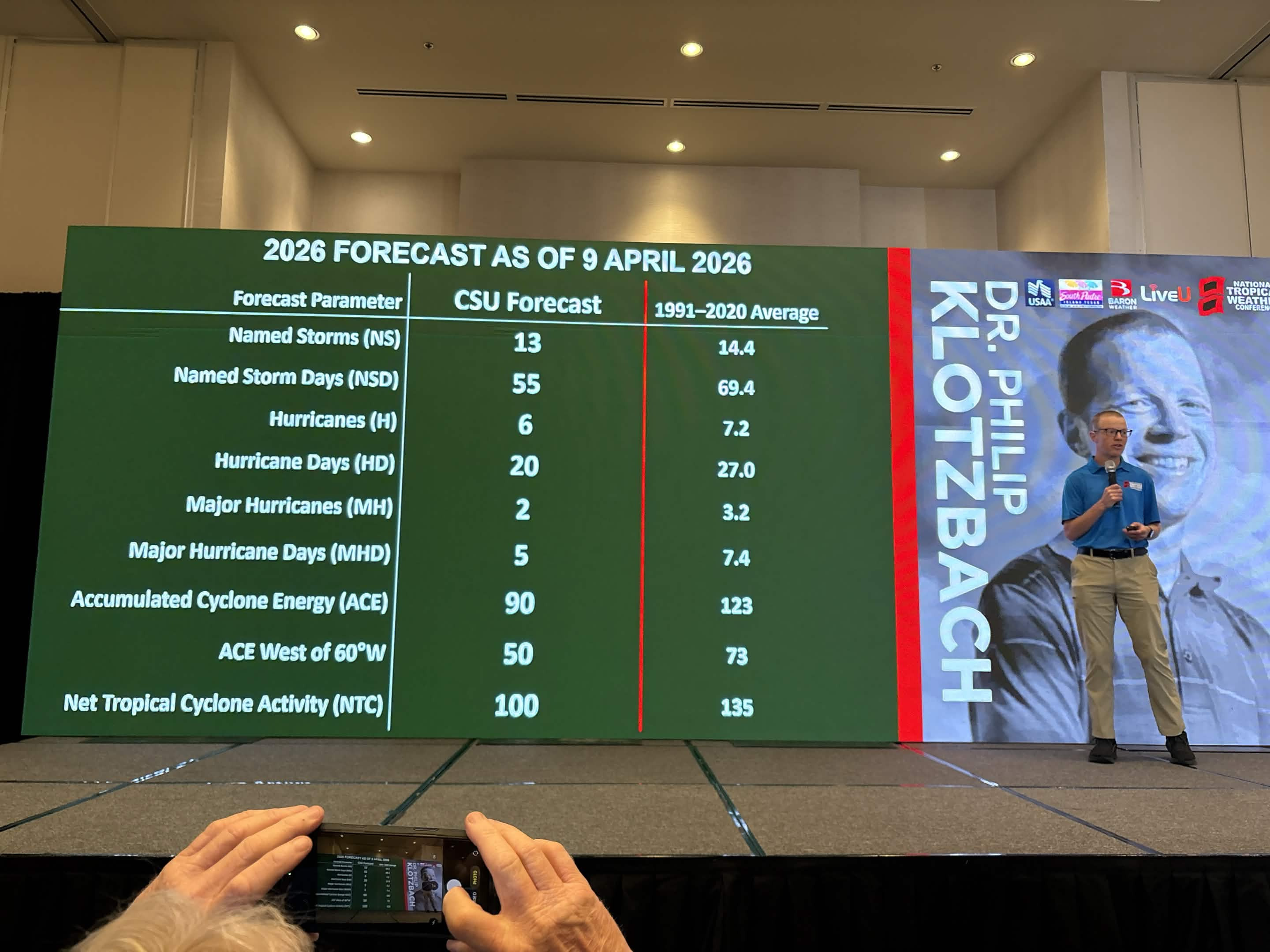
1. Seasonal Numbers at a Glance
CSU is projecting activity levels roughly 75% of a typical season.
2. The Florida Outlook: Landfall Probabilities
While the overall storm count is lower, Florida remains the most vulnerable state in the U.S. The 2026 report provides specific probabilities for major hurricane landfalls:
3. Primary Drivers: The "El Niño" Factor
The defining feature of the 2026 season is the transition from a weak La Niña to a moderate-to-strong El Niño during the peak months (August–October).
4. Historical Analogs
CSU identifies years with similar climate setups to help predict 2026’s behavior. The primary analog years are:
Your preparations should be identical to any other year. See https://www.floridadisaster.org/planprepare/preparing-for-hurricane-season/
One thing to note, this year has a higher chance for early season activity, even if only tropical storms. We'll be watching here at flhurricane.
This year we make it very easy to share images in posts, copy paste them in directly, or upload them for a button. You can then resize/crop them if you want. This is so you can share photos, satellites, model images and simple gif animations this year.
Windows folks can hit "Windows Key+Ctrl+S" to take snippets from your screen and then paste into here in the replies. more to come this year.
Reply here with your own guesses at numbers, which will close around the start of the season.
1. Seasonal Numbers at a Glance
CSU is projecting activity levels roughly 75% of a typical season.
- Named Storms: 13 (Average: 14.4)
- Hurricanes: 6 (Average: 7.2)
- Major Hurricanes (Cat 3+): 2 (Average: 3.2)
- Accumulated Cyclone Energy (ACE): 90 (Average: 123)
2. The Florida Outlook: Landfall Probabilities
While the overall storm count is lower, Florida remains the most vulnerable state in the U.S. The 2026 report provides specific probabilities for major hurricane landfalls:
- Florida Peninsula (South and East of Cedar Key): 15% (Long-term average: 21%)
- Gulf Coast and Panhandle (West of Cedar Key to Brownsville, TX): 20% (Long-term average: 27%)
- Proximity Risk: There is a 43% chance of a hurricane passing within 50 miles of Florida and a 21% chance of a major hurricane doing so.
3. Primary Drivers: The "El Niño" Factor
The defining feature of the 2026 season is the transition from a weak La Niña to a moderate-to-strong El Niño during the peak months (August–October).
- Wind Shear: El Niño typically creates high vertical wind shear across the Atlantic's Main Development Region (MDR). This "rips" storms apart before they can organize.
- Atmospheric Stability: Sinking air (subsidence) over the Caribbean and Atlantic is expected to suppress storm formation further.
- Atlantic Temperatures: While the Atlantic remains warm, it is not as anomalously hot as in recent record-breaking years, and the shear from El Niño is expected to be the dominant "hurricane slayer" this season.
4. Historical Analogs
CSU identifies years with similar climate setups to help predict 2026’s behavior. The primary analog years are:
- 2006 and 2009: Very quiet seasons for Florida landfall due to strong El Niño conditions.
- 2015: An extremely quiet year for the U.S. East Coast.
- 2023: A high storm count (20) but mostly storms that stayed out to sea, though Florida’s Big Bend was hit by Hurricane Idalia.
- Quality over Quantity: A below-average forecast does not mean zero risk. Forecasters frequently cite 1992 (Hurricane Andrew) as the ultimate warning: a very quiet, below-average year that produced one of the most devastating Category 5 landfalls in Florida history.
- Western Formation: Because El Niño suppresses storms in the deep tropics, 2026 may see more "homegrown" development in the Gulf of Mexico or Western Caribbean. These storms often have shorter lead times for us here in Florida.
Your preparations should be identical to any other year. See https://www.floridadisaster.org/planprepare/preparing-for-hurricane-season/
One thing to note, this year has a higher chance for early season activity, even if only tropical storms. We'll be watching here at flhurricane.
This year we make it very easy to share images in posts, copy paste them in directly, or upload them for a button. You can then resize/crop them if you want. This is so you can share photos, satellites, model images and simple gif animations this year.
Windows folks can hit "Windows Key+Ctrl+S" to take snippets from your screen and then paste into here in the replies. more to come this year.
Reply here with your own guesses at numbers, which will close around the start of the season.
Latest X/Twitter posts from Flhurricane Twitter Page
Tweets by cfhc

