cieldumort
Moderator

Reged:
Posts: 2342
Loc: Austin, Tx
|
 Tammy Lounge
Wed Oct 11 2023 12:55 PM
|
|
|
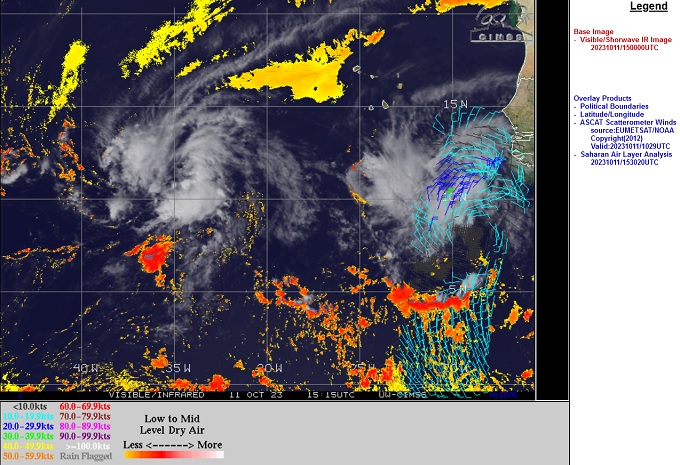
Above: Tropical Storm Sean (L) and Invest 94L (R)
Image cr. CIMSS
A tropical wave that has recently rolled off Africa and is tracking behind now Tropical Storm Sean from his east-southeast, may be one to watch. This wave is fairly well-developed, but presently being held in check from an abundance of dry air and may have a slow start at becoming a TC, thereby potentially keeping it at a lower latitude for longer as it tracks generally west.
Two competing scenarios from the Globals that in their own way make 94L a wave to watch:
1.Some global model runs suggest that 94L will follow well behind Sean, with Sean rounding the western extent of the high pressure currently steering Sean to the west, with that High then building in further westward as Sean exists to the north through an exit created by 93L (or by then perhaps reassigned a new Invest tag - or even name). By days 5-7 in this setup, 94L, or perhaps by then already a weak tropical cyclone, is sent much further west than Sean gets, per these model runs that keep it weak throughout this period.
2. Another possibility comes from runs such as today's 12z GFS, that weaken Sean , perhaps in the face of shear imparted upon him from approaching 93L, and send a hobbled Sean or his remnants into the northern Caribbean, with steering high pressure again building in from east to west, with the end result also being that 94L gets quite a bit west (and in this scenario, with Sean's remnants ahead of it in the Caribbean).
Lots of time to keep watch on both 94L and now Tropical Storm Sean. This is a rare time of year to see activity coming in from the Cabo Verdes, and there is little historical precedent with which to point to for likely outcomes.
Tropical Storm Tammy - Adv 1 5PM 10/18/23 - Ciel
Edited by cieldumort (Wed Oct 18 2023 08:09 PM)
|
|


 Flat
Flat


