cieldumort
Moderator

Reged:
Posts: 2336
Loc: Austin, Tx
|
 Record Setting Hurricane Barbara Landfalls
Tue May 28 2013 05:41 PM
|
|
|

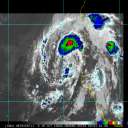
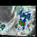
Tropical Depression #2 has formed in the Eastern Pacific today. TD2 is a healthy tropical cyclone that, if not for its close proximity to land, really looks like it could otherwise seriously take off.
TD2 grew out of an area of several competing disturbances that were all enhanced by the current phase of the MJO, or Madden-Julian Oscillation.
The MJO is a traveling intraseasonal feature in the tropics delivering what are effectively positive and negative pulses, respectively triggering alternating convective and stable phases.
At the moment, the convective, wet phase of the MJO is established over the far eastern Pacific, and is starting to exert its presence in the far western Atlantic. This is following a fairly typical pattern of the MJO - one can often watch it fire up tropical disturbances in the east pac, and expect to see some enhanced activity then push into the Gulf or Caribbean within a few weeks later.
The timing of the MJO's entrance into the western Atlantic is particularly interesting right now, as TD2 is forecast by several better models to actually head north-northeast, about into, if not across, the Isthmus of Tehuantepec in southern Mexico. Indeed, this is also the first official forecast from the NHC.
Should TD2, even if only as a post tropical cyclone or remnant circulation, make it across southern Mexico and into the Bay of Campeche during the enhanced, convective phase of the MJO, it will definitely become something to watch over here on the Atlantic side.
While not at all a common occurrence, as recently as 2008 the Atlantic's first named storm of the year, Arthur, was born in large part from the remnant circulation of an eastern Pacific tropical cyclone, Alma, that had entered the extreme western Caribbean by way of Central America.
Edits to reflect upgrade to named storm/hurricane, landfall status and record-setting status.
Edited by cieldumort (Wed May 29 2013 04:55 PM)
|
|


 Flat
Flat


