MikeC
Admin
Reged:
Posts: 4603
Loc: Orlando, FL
|
 Watching an area into August
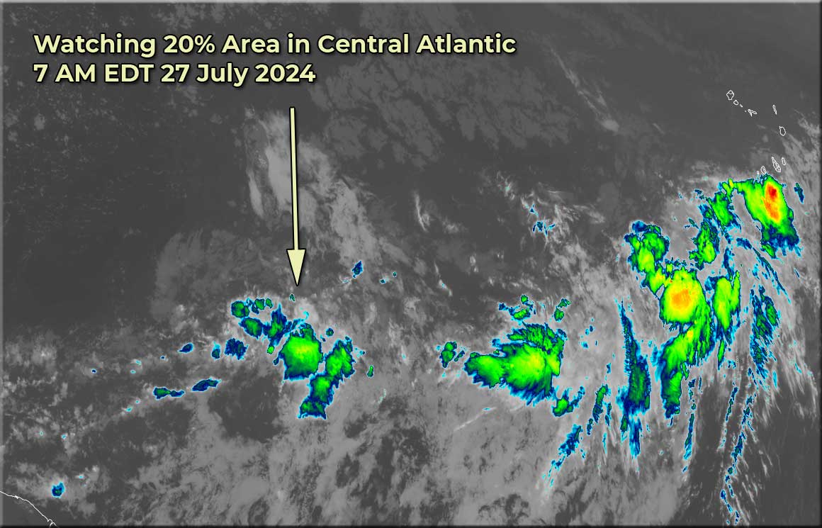
Sat Jul 27 2024 07:07 AM
|
|
|
10:20AM EDT 02 August 2024 Update
Potential Tropical Cyclone Advisories will begin at 11AM for 97L with Tropical Storm watches up for parts of Florida.
8AM EDT 02 August 2024 Update
The area (Invest 97L) being watched is now over Cuba and expected to move into the Gulf sometime tomorrow. Chances are up to 90% of formation in the next 7 days (60% chance within the next 48 hours). The main impacts are very heavy rain for parts of Cuba, Bahamas and Florida. The chance for a stall over the Gulf has gone down. The main rain days for Florida are Saturday (more afternoon and onward) and Sunday. Beyond that depends on how fast the system moves. Those in the Southeast, including Georgia, South and North Carolina should also watch the system closely. The system won't be able to form a true center until it bypasses Cuba, so exact track won't mean much, and it's unlikely to develop beyond a tropical storm in the Gulf. The next name is Debby.
Tropical Storm watches could go up later today, likely with the issuance of a Potential Cyclone Advisory. (How they issue watches/warnings before a depression or storm initially forms)
8AM EDT 01 August 2024 Update
The area of interest is generally near Hispaniola (DR/Haiti) and still large and unorganized, however convection and upwelling has increased quite a bit since Wednesday. Still at a 60% chance to develop over the next 7 days, it has a 20% chance to develop within 48 hours (Which will likely go up even more by tomorrow). The system could form near Florida or in the eastern Gulf and beyond then the models differ a lot except for a key point that the system may get blocked from moving north and stall out or meander somewhere either over land or the Gulf of Mexico, or both.
Since nothing has developed and there's the potential for a blocking (Col) high that has the potential to stall the area out makes the forecast extremely difficult, and it may mean relatively quick watches/warnings and changes over the next few days, so it's important to keep watch on it very closely, watches could come as early as tomorrow night for some parts if needed. If it stalls over the Gulf, there is a chance it could get stronger. Regardless of strength, the potential for flooding rainfall in Florida and Southeastern/Gulf states is there. Those in
some of the Greater Antilles Caribbean islands are seeing that rainfall now.
8AM EDT 31 July 2024 Update
The area now in the Northeastern Bahamas still has a 60% chance to develop later in the week (Friday night or Saturday) The large, but dry wave is slowly, but surely gaining moisture as it moves westward and is currently bringing some rain to the Leeward islands. The future of the system depends a great deal on how organized at gets, and exactly where, which is reflected in the National Hurricane Center's formation region. (This isnt' a track cone) Where it could develop in the Bahamas, move into Florida or into the Gulf, with the odds only slightly favoring it to move east of Florida) It's unlikely to develop quickly however, thus the most likely outcome is a lot of rain for the areas it goes over.
This means In the short term, Leeward islands, the Virgin Islands, and Puerto rico will see just rain from the disorganized system, as it moves toward Hispaniola it will likely bring rain there as well, entering the Bahamas and Turks and Caicos, is the area where it could start to develop, but while over there it would bring much rainfall which likely will spread into Florida. Later Saturday and Sunday in particular seems like a very wet day for Florida, beyond that too soon to say really how much, if, and where the system develops. But it's important to be aware of from the Gulf coast to the Carolinas, including Florida. If it were to develop closer to Florida, a Tropical Depression or Storm is possible. The next name on the list is Debby.
8AM EDT 30 July 2024 Update
The area in the Central Atlantic now has a 60% chance to develop later this week (closer to this weekend). Since it's a delayed development situation, those in the Greater Antilles, the Bahamas, Florida, and the Southeastern US should monitor the progress of this system. The biggest visible with the large wave, a large and broad spinning area is now visible on satellite, but it's still void of much convection. It has the potential to be a large rain maker for Florida and the Bahamas, and possibly elsewhere. Models are mixed on the system from Western Gulf to east of the Carolinas, with a few over Florida as well, with the added twist of a blocking high occurring which may stall the system out somewhere close to or over land and cause it to move erratically. With nothing developed and unlikely to until late in the week there's still not a great deal of confidence. It's likely to remain a weak system at least in the short term.
8AM EDT 29 July 2024 Update
The area in the Central Atlantic is now up to a 50% chance to develop over the next 7 days, and if it does, may not develop until later in week when it's closer toward the Greater Antilles or Bahamas. That means no invests for a while either, and the models are split between the weaker ones entering the Gulf and most others staying east of Florida and near or just east of the Bahamas. Staying east of Florida is currently most likely. However, it's worth checking over the next few days since it's nowhere near developed.
The area currently is void of much convection and it's dry, but is expected to move into an area where it will likely gain convection later in the week.
8PM EDT 27 July 2024 Update
The Area in the Central Atlantic is now up to a 40% chance to develop over the next 7 days, those in the Leeward islands should watch closely, but it's unlikely to develop in the near term until it gets further west toward the middle of the week. If it were to approach the mainland US the timeframe would be Sunday-Monday or Tuesday Aug 4-5. However it's too early to say where it will go until it develops (if it does) and where. It's currently not being tracked as an invest area.
Originial Update
There's a new area in the Main Development Region of the Central Atlantic that's being watched by the National Hurricane Center with currently a 30% chance for development. It's not currently being tracked as an invest area. This area is moving fast, so development is more likely later than earlier next week. Potential timing is Thur-Friday for Lesser Antilles, and then moving closer to the west, if it were to affect the US it would likely be in the Saturday-Monday time frame starting August 3rd.
Where exactly could be the Gulf to out to sea since we have no invest much less a developed storm yet. And likely won't develop, if at all, until near or just past the islands,
There's a good amount of time to watch this as it moves generally westward.
Additionally another possibly short lived area may head up toward New England early next week, and has a small chance to become subtropical.
{{StormLinks|PTC4|04|4|2024|PTC4|Potential Tropical Cyclone Four}}
{{StormCarib}}
{{NortheastGulfRadar}}
{{TampaMedia}}
{{SWFloridaMedia}}
Edited by CFHC (Fri Aug 02 2024 10:21 AM)
|
|


 Flat
Flat


