cieldumort
Moderator

Reged:
Posts: 2346
Loc: Austin, Tx
|
 BERYL
BERYL
Mon Jul 01 2024 11:01 PM
|
|
|
4:15 PM CDT 5 July 2024 Update
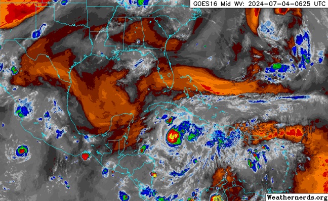
Beryl has a history of over-performing and is about to exit the Yucatan north of where many models and their ensembles had forecast. It is likely just a matter of time before the cyclone becomes a strong hurricane again, and regardless of whether or not it Majors again, and it might, forward motion is expected to slow down. Ongoing surge, heavy rain and severe to extreme wind are threatening to batter some of the most sensitive and populated parts of Texas, and perhaps Louisiana.
4 AM CDT 5 July 2024 Update
A significant northward shift towards Texas in the most recent model consensus , plus numerous ensemble members not only coming in further north up along the Texas coast late Sunday or Monday, but also quite a bit stronger, will likely necessitate Hurricane and Tropical Storm Watches along portions of the Texas coast by tonight.
With the 4AM CDT NHC Advisory, a landfall in Texas rather than Mexico is now forecast. Additionally, the Hurricane Center outlines how additional northward adjustments to the track could be coming:Quote:
The hurricane appears to now be moving more west-northwestward this morning, estimated at 285/13 kt. Beryl should maintain this west-northwest heading as it crosses the Yucatan Peninsula today and emerges over the Gulf of Mexico by tonight. Thereafter, the subtropical ridge north of Beryl that has been steering it for many days now will become eroded in the western Gulf of Mexico from a long-wave trough located over the Central U.S. In addition, an upper-level low seen retrograding westward in the Gulf of Mexico
could also impart more poleward steering in the western Gulf of Mexico. How sharply Beryl turns poleward from 36-72 h will likely depend on the storm's vertical depth, with a more vertically deep system more likely to feel the ridge weakness and upper-level flow. In fact, that scenario has been highlighted by the last few cycles of the ECMWF ensembles which show stronger solutions on the north side of the track envelope. The overall guidance this cycle has also made a notable shift northward and is a bit slower than earlier, and
the NHC forecast track has been shifted in that direction, quite close to the consensus aid TVCN. However, it is not quite as far north as the latest ECMWF or GFS tracks, and further adjustments in that direction may be necessary later today.
2 AM EDT 4 July 20214 Update
Happy Independence Day, America!
Beryl seems to have declared its independence from Jamaica, and is increasingly less tangled up in the island. Additionally, outflow may be getting a little more effective at battling back westerly/southwesterly shear again. Furthermore, waters in the northwestern Caribbean are expectionally warm, and shear may even relax by Friday. As such, it would not be surprising to see Beryl still a formidable hurricane en route to the Yucatan.
Longer-range, NHC explicitly forecasts that Beryl enters deep south Texas early next week. It is still less certain whether, should this happen, it would do so by way of landfalling along the Texas coast, or coming up from just south of the TX/MX border. Entrance through the Texas coast not only implies greater impacts on the state just by the location of landfall, but potentially a stronger system as well.
Those along the coast and just inland from Tampico, Mexico to greater Houston, TX may want to keep checking back a little more often over the next 96 hours or so.
11 AM EDT 3 July 20214 Update
Hurricane Beryl has been on a weakening trend, but not nearly fast enough or weakening enough to spare places like Jamaica, the Caymans and the Yucatan coming up, from hurricane-force winds torrential rains, flooding and mudslides. In addition, life-threatening surge could raise water levels up to 9 feet above normal tide levels in areas of onshore winds along the immediate coast of Jamaica.
SUMMARY OF WATCHES AND WARNINGS IN EFFECT:
A Hurricane Warning is in effect for...
* Jamaica
* Grand Cayman
* Little Cayman and Cayman Brac
* The coast of the Yucatan Peninsula of Mexico from Puerto Costa Maya to Cancun
A Hurricane Watch is in effect for...
* The coast of the Yucatan Peninsula of Mexico south of Puerto Costa Maya to Chetumal
* The coast of the Yucatan Peninsula of Mexico north of Cancun to Cabo Catoche
A Tropical Storm Warning is in effect for...
* South coast of Haiti from the border with the Dominican Republic to Anse d'Hainault
* The coast of the Yucatan Peninsula of Mexico south of Puerto Costa Maya to Chetumal
* The coast of the Yucatan Peninsula of Mexico north of Cancun to Cabo Catoche
A Tropical Storm Watch is in effect for...
* Coast of Belize from south of Chetumal to Belize City
* The coast of the Yucatan Peninsula of Mexico west of Cabo Catoche to Campeche
1:45PM EDT 2 July 20214 Update
Category 5 historic Hurricane Beryl is now about 500 miles east-southeast of Kingston, Jamaica tracking west-northwest. Generally speaking, many models have been trending poleward over all, which is unsurprising given Beryl's stronger (deeper) state that helps these cyclones feel more of the tugs and shoves north, and that these models now also have the benefit of loads of invaluable recon data.
Initially, there were many forecasters proclaiming that Beryl would never reach the US. This is foolishness. We should never put too much stock in a hurricane forecast out much past five days, with exceptions.
It is now time for those with interests in the northwestern Caribbean to eastern Mexico and the northwestern Gulf of Mexico including potentially the southern United States, to begin paying more attention, and for those in Jamaica specifically to begin making preparations to protect life and property.
Forecasts for Beryl's track and intensity will continue to update and be fine-tuned as the cyclone draws closer to each individual location, and it is always advisable to listen most to the National Hurricane Center and trusted local weather and emergency management experts.
11AM July 2 2024 SUMMARY OF WATCHES AND WARNINGS IN EFFECT:
A Hurricane Warning is in effect for...
* Jamaica
A Hurricane Watch is in effect for...
* South coast of Haiti from the border with the Dominican Republic to Anse d'Hainault
* Grand Cayman
* Little Cayman and Cayman Brac
A Tropical Storm Warning is in effect for...
* South coast of Dominican Republic from Punta Palenque westward to the border with Haiti
* South coast of Haiti from the border with the Dominican Republic to Anse d'Hainault
Original Update

Throughout Monday, Hurricane Beryl continued to further organize and intensify, defying official forecasts for a plateauing, and shortly before the 11PM Advisory came out, recon found definitively that Beryl has become a Category 5 hurricane with maximum sustained winds of 160 MPH. With this, Beryl now sets yet another all-time record, this time for the earliest forming Cat 5 in the Atlantic.
Quote:
SUMMARY OF 1100 PM AST...0300 UTC...INFORMATION
-----------------------------------------------
LOCATION...13.8N 64.9W
ABOUT 510 MI...825 KM ESE OF ISLA BEATA DOMINICAN REPUBLIC
ABOUT 840 MI...1355 KM ESE OF KINGSTON JAMAICA
MAXIMUM SUSTAINED WINDS...160 MPH...260 KM/H
PRESENT MOVEMENT...WNW OR 290 DEGREES AT 22 MPH...35 KM/H
MINIMUM CENTRAL PRESSURE...938 MB...27.70 INCHES
WATCHES AND WARNINGS
--------------------
SUMMARY OF WATCHES AND WARNINGS IN EFFECT:
A Hurricane Warning is in effect for...
* Jamaica
A Tropical Storm Warning is in effect for...
* South coast of Dominican Republic from Punta Palenque westward to the border with Haiti
* South coast of Haiti from the border with the Dominican Republic to Anse d'Hainault
Beryl Forecast Lounge (Including model deep dives)
{{StormLinks|Beryl|02|2|2024|Two|Beryl}}
{{StormCarib}}
Edited by cieldumort (Fri Jul 05 2024 05:19 PM)
|
|


 Flat
Flat


