cieldumort
Moderator

Reged:
Posts: 2349
Loc: Austin, Tx
|
 Beryl Heads to Texas
Sat Jul 06 2024 09:09 PM
|
|
|
4AM CDT 8 July 2024 Update
Beryl has made landfall near Matagorda. 979mb 80 MPH Cat 1. Flooding, surge, wind damage and tornadoes are all underway.
WATCHES AND WARNINGS
--------------------
CHANGES WITH THIS ADVISORY:
The Tropical Storm Warning has been discontinued south of Mesquite Bay Texas.
SUMMARY OF WATCHES AND WARNINGS IN EFFECT:
A Storm Surge Warning is in effect for...
* Mesquite Bay to Sabine Pass, including Matagorda Bay and GalvestonBay
A Hurricane Warning is in effect for...
* The Texas coast from Mesquite Bay northward to Port Bolivar
11PM CDT 7 July 2024 Update
Beryl was upgraded to hurricane with a special advisory.
Original Update
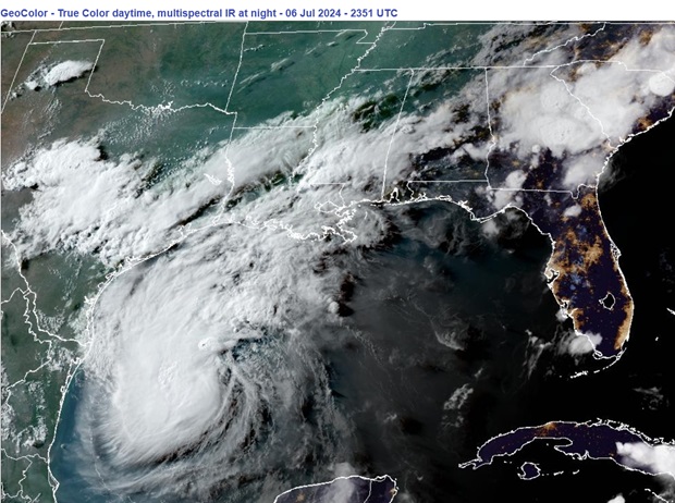
Above: Tropical Storm Beryl at Sunset on approach to Texas July 6, 2024
Beryl is still in its reconstruction phase tonight, having had a serious interruption of its core during passage across the Yucatan, and its convection during exit over the cooler shelf waters while being blasted with some dry air.
Little by little, now Tropical Storm Beryl is clearing out the dry air and rebuilding the inner core, and is still expected to become a hurricane once again and make landfall on the central Texas coast as a Cat 1. Impacts should be felt far and wide along Beryl's track, with some locations getting the worst of the wind and/or rain/flooding. The exact location of landfall and worst weather will become more certain as the storm draws closer, but mandatory evacuations in some of of the more sensitive and vulnerable places have already begun.
SUMMARY OF WATCHES AND WARNINGS IN EFFECT AS OF 7PM CDT JULY 6
A Hurricane Warning is in effect for...
* The Texas coast from Baffin Bay northward to Sargent
A Hurricane Watch is in effect for...
* The Texas coast south of Baffin Bay to the mouth of the Rio Grande River
* The Texas coast north of Sargent to San Luis Pass
A Tropical Storm Warning is in effect for...
* The Texas coast south of Baffin Bay to the mouth of the Rio Grande River
* The Texas coast north of Sargent to High Island
* The northeastern coast of mainland Mexico from Barra el Mezquital to the mouth of the Rio Grande River
A Storm Surge Warning is in effect for...
* North Entrance of the Padre Island National Seashore to High Island, including Corpus Christi Bay, Matagorda Bay, and Galveston Bay
A Storm Surge Watch is in effect for...
* The Texas coast from the mouth of the Rio Grande River northward to North Entrance of the Padre Island National Seashore
* San Luis Pass to Sabine Pass, including Galveston Bay
Beryl Forecast Lounge
{{StormLinks|Beryl|02|2|2024|Two|Beryl}}
{{TexasGulfRadar}}
{{TexasRadar}}
Edited by cieldumort (Mon Jul 08 2024 05:01 AM)
|
|


 Flat
Flat


