CFHC

Reged:
Posts: 149
Loc: East Central Florida
|
|
This is an early start with multiple model agreement on the potential for something to form early to mid next week in the MDR. Right now it's over the coast of Africa.
There's rather strong model support for development from the and Euro, and some from the and Icon as well.
The Euro ensembles are particularly locked onto development, so the 20% chance on the initial outlook seems good. Once the system fully moves off the coast of Africa tomorrow it'll have a few days. There are some negative factors for development, but the very high water temps right now are a big positive, which will likely allow it to develop once in then Central Atlantic. Another negative for development is generally dry air in the MDR this time of year, which is true this year as well.
Beyond this those in the Eastern Caribbean/Leewards will want to see where it goes, but the long term track is split between a Caribbean system and veering north. Track is typically not something to rely on the long range models for, especially before its actually developed.
Invest 92L has become a tropical cyclone and at 11AM AST June 19, Advisories have begun on TD3. The title has been updated accordingly. At 5pm AST June 19 THREE is being upgraded to Bret and the title has been updated again.
-Ciel
Edited by cieldumort (Mon Jun 19 2023 08:36 PM)
|
MikeC
Admin
Reged:
Posts: 4544
Loc: Orlando, FL
|
|
18z again drops the west Caribbean system, but does get the MDR system (now with a 30% chance to develop) into the Bahamas as a hurricane. The Leeward islands will definitely need to watch this system over the coming week.
Beyond this the shows yet another potential MDR system in the longer range.
Shear won't be too bad in that timeframe, but the largest negative factor for development will likely be dry air . Sea surface temperatures are very high right now.
|
MikeC
Admin
Reged:
Posts: 4544
Loc: Orlando, FL
|
|
6z and euro are showing a curve no0rth before the islands this morning which is a hopeful sign that this system will stay away from land areas, which is more probable the stronger the system gets with this setup. Odds are up to 40% on the outlook this morning for development.
|
MikeC
Admin
Reged:
Posts: 4544
Loc: Orlando, FL
|
|
12z recurves well before the islands around 55west, 12Z Euro gets much closer to the islands when the recurve in earnest happens around 60W as a cat 2 hurricane (However it puts Bermuda in a position to watch it closely). Neither crosses the Caribbean islands.
Euro ensembles has more spread than the , some of the ensembles do cross into the Caribbean. However, with the caveat that the system has not formed yet, the odds favor a recurve before the Caribbean islands at the moment.
12z Canadian /Gem keeps it much weaker and it goes into the Caribbean all the way to Cuba. 12Z icon recurves it similar to .
In short this is a setup that is good for the rule of thumb weaker=further west, stronger=more likely to recurve.
|
MikeC
Admin
Reged:
Posts: 4544
Loc: Orlando, FL
|
|
The 18Z develops the system a bit more vigorously, shifts a bit west from the 12Z, but turns north before the Caribbean and misses Bermuda to the east. However this run of the does get the system to major hurricane strength (957mb) along the run, which is unheard of for June in the main development region (MDR).
We'll see how this holds up, but it would start to develop Monday if it holds true.
There is no sign of the phantom system in the west Caribbean on this run.
|
MikeC
Admin
Reged:
Posts: 4544
Loc: Orlando, FL
|
|
This is now invest 92L
|
MikeC
Admin
Reged:
Posts: 4544
Loc: Orlando, FL
|
|
The models this evening are split between a recurve, and a 12Zeuro right into the Caribbean. The ensembles show this as well, following the rule stronger is more likely to recurve. However, the HWRF does get stronger and doesn't recurve. So it's a bit of a mystery here. There's still quite a bit to follow with 92L, and I can't assume it's going to recurve before the Leeward islands yet.
One interesting thing about the 0z euro is that it does take it right into DR/Hispaniola and it falls apart there. The system is looking better on the satellite.
|
MikeC
Admin
Reged:
Posts: 4544
Loc: Orlando, FL
|
|
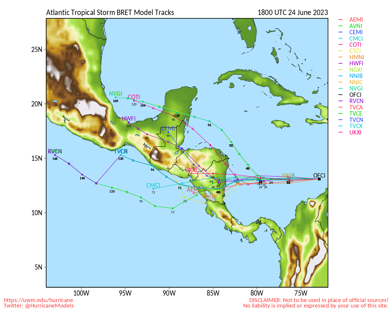
6 recurves 92l around 52W. Euro has it moving through the leewards, just south of Antigua, on Saturday Jun 24th, but very weak.
CMC and Icon has it over ST. Lucia, weak, on Friday.
The Hurricane Models,
HWRF: Cat 2/3 just northeast of Barbados at end of run (Friday)
HMON: Cat 2/3 just northeast of Barbados at end of run (Friday)
HAFSA: Cat 2/3 just northeast of Barbados (further north than than HWRF/HON) at end of run (Friday)
HAFSB: Cat 3/4 just northeast of Barbados (closer to Barbados than the other models) at end of run (Friday)
The two newer models, HAFS A/B will replace the HWRF/HMON. A is replacing the HWRF, B is replacing the HMON. But all 4 will run this year. None of the hurricane models are all that great with inverts before an actual storm forms, but they are another thing to consider. Once you have a TS, though, they can be more useful.
|
MikeC
Admin
Reged:
Posts: 4544
Loc: Orlando, FL
|
|
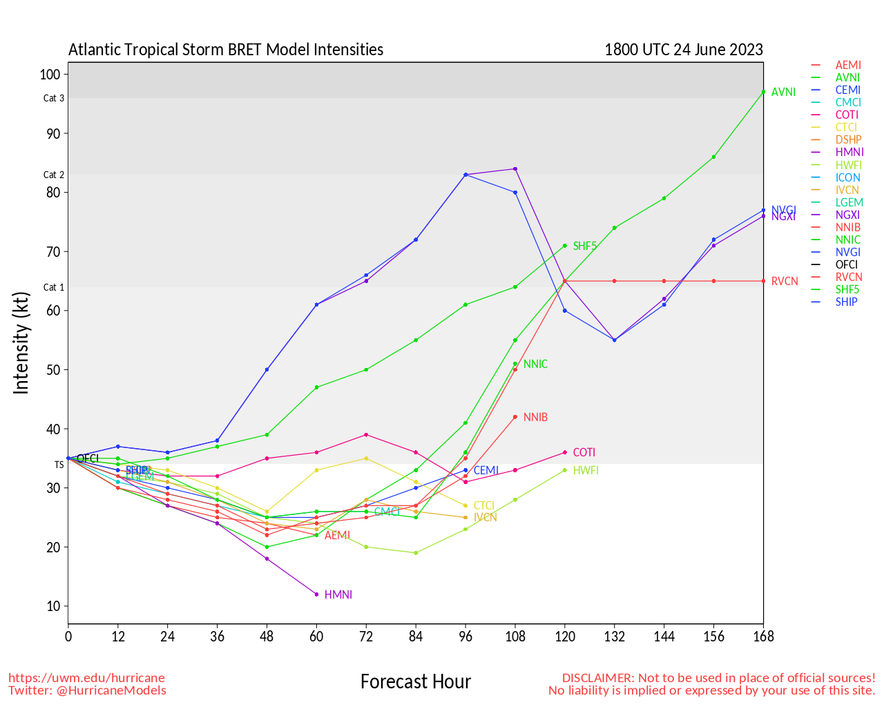
12z euro is going weaker, and more westerly in this run (followed by another system behind that).
12z Recurves around 52-53 W and keeps it out to sea (much stronger).
I'm leaning toward the weaker, maybe a 45knot peak with this system, which means the islands need to keep watch closely.
The also spins up another weak west Caribbean system that goes into Florida later this week, but don't expect that to happen.
The canadian doesn't develop 92L at all.
|
MikeC
Admin
Reged:
Posts: 4544
Loc: Orlando, FL
|
|
12z euro is going weaker, and more westerly in this run (followed by another system behind that).
12z Recurves around 52-53 W and keeps it out to sea (much stronger).
I'm leaning toward the weaker, maybe a 45knot peak with this system, which means the islands need to keep watch closely.
The also spins up another weak west Caribbean system that goes into Florida later this week, but don't expect that to happen.
The canadian doesn't develop 92L at all.
UKMet picks it up for development east of the Leewards.
|
JMII
Weather Master

Reged:
Posts: 489
Loc: Margate, Florida
|
|
Strange to see a Cape... sorry Cabo Verde type storm so early in the season. Wikipedia lists Bertha on July 3 as the soonest. Presentation on satellite looks pretty good with some outflow channels already being to form.
--------------------
South FL Native... experienced many tropical systems, put up the panels for:
David 79 - Floyd 87 - Andrew 92 - Georges 98 - Frances 04 - Wilma 05 - Matthew 16 - Irma 17
Lost our St James City rental property to Ian 22
|
OrlandoDan
Weather Master

Reged:
Posts: 443
Loc: Longwood, FL
|
|
If he stays weak, he will atay south. If strong,, he heads to the pole. Medium, and he tracks toward Florida.
--------------------
Keith (1988), Charley (2004), Frances (2004) , Jeanne (2004), Fay (2008), Mathew (2016), Irma (2017), Dorian (2019)
Personal Weather Station: https://www.wunderground.com/dashboard/pws/KFLLONGW67
|
JMII
Weather Master
Reged:
Posts: 489
Loc: Margate, Florida
|
|
The models are being to come to a better agreement on that weak/south path thankfully. Still has decent form on the satellite images but you can see the shear starting to take effect. Newest forecast has backed off it becoming a hurricane.
--------------------
South FL Native... experienced many tropical systems, put up the panels for:
David 79 - Floyd 87 - Andrew 92 - Georges 98 - Frances 04 - Wilma 05 - Matthew 16 - Irma 17
Lost our St James City rental property to Ian 22
|


 Threaded


