MikeC
Admin
Reged:
Posts: 4667
Loc: Orlando, FL
|
|
8:50 AM EDT 14 Aug 2007 Update
Caribbean disturbance (90L) is still getting its act together and may become a depression later today, recon is going out later today as well.
TD#4 is a bit better looking this morning, and models are trending back west a bit, once again increasing chances that the storm could affect the leeward islands.
Beyond that, still too early to tell, but it would be prudent to watch it.
It is very likely we will see TD#4 become a Tropical Storm late today, but right now numbers (Satellite windspeed estimates) do not support a tropical storm.
More to come later.
2:45 AM EDT 14 Aug 2007 Update
Neither system has developed much more since yesterday, although potential for 91L to develop today (the 14th) is still there. TD#4's convection hasn't been around the center of circulation lately, so it's further development is in check. The forecast track has shifted slightly north, reducing the potential impact in the Leeward islands, but the errors are still large.

Beyond the islands, it's still much too early to call. The best case would still be a curve away from land, and it is looking less likely this system will go into the Caribbean now. Still those in the area will want to watch because of the possibility for track errors at that range.
We will continue watching the progress on it.

91 didn't have enough last night to make it into a depression or storm, but it is looking better on satellite in the early morning hours. Chances are still high that it will develop sometime later today. Track thoughts haven't changed much on it either.
1:20 PM EDT Update
A Tropical Cyclone Formation Alert has been issued for 91L in the gulf, meaning a depression or Tropical Storm is likely to form there within 24 hours.
11AM EDT Update
Tropical Depression Four advisories are out, the is currently projecting a track through the Leeward Islands as a category 1/2 hurricane later in the week. However, the margin of error is pretty high this far out, but those in those islands should monitor this system accordingly.
Tropical Storm Dean is expected to form from TD#4 later tonight or tomorrow. (This may change to Erin depending on the status of the Gulf System)
Over in Hawaii Hurricane Flossie is projected to move south of the Islands, but a Hurricane Watch is up for the Big Island of Hawaii. More information on Flossie at and in this thread.

To reiterate as well for the system in the gulf, those along the western coast of the Gulf of Mexico should pay attention to the system developing in the Gulf (91L), it could form into a depression or more later today or early tomorrow.
10AM Update
West Caribbean System is now being tracked as 91L, and this system has a chance to finally develop again. Things are about to get really busy. Early models suggest 91L may be headed to extreme southern Texas. It doesn't appear it will have the time to strengthen into anything too major, but is indeed worth watching -- after all it is August and water temps in the Gulf are very warm.
Those in the western Gulf Coast should be watching this, as it could form into a depression later today or early tomorrow. Aircraft recon is scheduled to visit this area tomorrow.
More to come later on it and TD#4 as it comes in.

Original Update
Tropical Depression #4 has formed in the far eastern Atlantic from the wave called 90L, and is still moving west. The first advisories should begin at 11AM EDT.
Plenty of time to watch, the prior update is posted below which explains the thinking so far, which hasn't changed much.
More to come later.

Older Updates
9AM 13 Aug 2007 Update
Indications from satellite estimates suggest that 90l may now be a tropical depression, advisories may start as early as 11AM EDT.
5:20PM EDT Update
The wave off Africa has been designated invest 90, and is being tracked by the as such. Model runs have began on it, and I'm not liking what I see. Westward ho--for a good while, 90 L will likely be this year's first long track Cape Verde system. (really the first since in 2004--this does NOT mean I think it will take a track like , however)

Chances for Tropical Development of Wave off Africa (90L) In Next 3 days (Updated 9AM 12 Aug - Issued)
Code:
(forget it) 0 1 2 3 4 5 6 7 8 9 10 (sure thing)

            [--------------*-----]
It has the potential, if it persists, to become a depression over the next few days. The stronger it gets further east out in the Atlantic, the more likely it will recurve away from the Caribbean and potentially out to sea. Conversely, and more likely, the weaker it remains longer, the more likely it will continue a westward track.
As mentioned, this is the first potential Cape Verde storm of the season, and it should be a reminder to those in the Caribbean to be prepared. Even though we have a good number of days to watch 90L.
Remember it takes a few days for models to get a handle on newly formed systems, and data out in the Central and Eastern Atlantic for upper level winds isn't all that great. Many waves off Africa die down a bit after the initial phase, so it is possible the system will lose it, and hopefully it will. However conditions are good enough to hold it together for the foreseeable future.
Those in the lesser Antilles will want to watch for it by next late next week into the weekend (16-18th) , there is a decent chance a storm will be near or over there at that time. As such soon thereafter others in the Caribbean may need to watch.
For those along the east coast of the US, i'd watch it, if would be just about a week and a half out (21st) for it to get anywhere close to us, assuming it doesn't fall apart or curve out to sea before then.
Now for the realm of speculation, based on models...

What we don't want is the scenario given by some of the super long range models, The long range earlier today had the system heading toward South Florida (Also EMCWF), and later into the Gulf near Houston, ( See this and This)
I'm sure it'll be back somewhere else at the next runs around midnight. What does this mean? Nothing--models at that range are about the same as throwing a dart from a moving car on a dirt road, but it's another sign that the season is about to get active and that we must watch. Average error for models at that range is over 1000 (a thousand) miles.
Intensity wise, the first run on the system takes it to Hurricane strength by the time it gets to 40 degrees west. (Currently it is at 20 degrees West), the HRWF model brings it to a Category 3 hurricane before reaching the Caribbean.
It's more important for East Coast and Gulf Coast folks, just wait to see model trends, and do not take any one run of the long range models to heart right now. I certainly don't think much of them beyond Wednesday or so as worth anything,.
With that said, we'll definitely be watching it, and it's a good idea to check back during the week to see the updates with this system, especially if it develops into a named Storm. The next name up on the list is Dean. There are other indications that other storms may follow this one as well, which is not too uncommon for mid to late August.
Not to forget the West Caribbean System, it's closer to land and still not really moving much, it still needs to be watches as well, but it is less likely to develop.
Chances for Tropical Development of Disturbance in Western Caribbean
Code:
(forget it) 0 1 2 3 4 5 6 7 8 9 10 (sure thing)

            [-----*--------------]
|
twizted sizter
Weather Guru
Reged:
Posts: 184
|
|
To allan from the previous thread...no harm from the in not upgrading sooner. Take it with a grain of salt where the complaints were coming from...there's a reason none of those bloggers work at the .
Mike is right..this far out modeling flip-flopping is par for the course & the immediate threat is to those in the islands...way too early to say what if any impact this will have to the .
Use this time to finalize any preps..replace the Spaghettios the kids ate over the summer, stock up on gas(if this does threaten the , especially the Gulf, I dread what gas will shoot up too) and watch & wait.
As a storm weary...especially after '04..Fl native, I look forward to just watching a fish-spinner. The insurance crisis we already face would become unbearable if we endured another direct hit.
|
twizted sizter
Weather Guru
Reged:
Posts: 184
|
|
Appears the has tagged the system in the WCarb as 91L. Haven't fully looked at the runs this a.m. but I believe they had drifted more towards Texas than Mexico now.
Seems the switch has been flipped on now.
|
madmumbler
Storm Tracker

Reged:
Posts: 324
Loc: SWFL
|
|
I was FINALLY able to get the site to load and saw 91L was up. BUT, I think it's heading west (from the water vapor loop image) and maybe will miss mainland US. (Not to wish ill on anyone else, but today is the 3rd anniversary of and I'm not anxious to repeat that anytime soon!)
Question -- if it's not TD 4 on the site (yet) or on the site (yet) then where exactly did the info come from that they upgraded it? What site link am I missing from my bookmarks list? *LOL* (I'm NOT doubting it was upgraded, just wondering where we can look to see the info).
EDIT: -- Okay, maybe I'm a moron. It's because it's designated as noname 4 on the site that means it's been upgraded, right? I couldn't get for the past few days to load at all.
--------------------
Lesli in SWFL.
Friends help you move. Real friends help you move bodies.
Edited by madmumbler (Mon Aug 13 2007 10:21 AM)
|
Random Chaos
Weather Analyst

Reged:
Posts: 1024
Loc: Maryland
|
|
04L:
GFDL is showing this thing growing strong before it hits the windwards. Definately a storm to watch.
Not sure what is up with TCGenisis site - seems to be half broken (the page is unskinned and half the model runs won't load). Cyclone Phase also seems to be lacking data at . Alternative site with the model runs (though looks like the is broken there too): http://met.psu.edu/tropical/tcgengifs/
91L:
Looking at the UKMET, the predicted track takes it north and then swings west into southern TX. The question is how much it will be able to develop before it hits. Right now it's still disorganized pre-TD status.
I'm tracking it via vorticity since without 's site working I can't get the resolution for MSLP on my alternate source for the UKMET.
UKMET - vorticity shown:
http://weather.uwyo.edu/cgi-bin/model?MO...one&C1=pmsl
Edited by Random Chaos (Mon Aug 13 2007 10:29 AM)
|
aboz56
Registered User
Reged:
Posts: 3
Loc: Louisville, KY
|
|
I stumbled across this site as I was looking for weather forecasts for next week in the Destin, Florida area. After all, I'm heading there for a trip next week.
There seems to be something brewing out in the Atlantic and I'm having a hard time following some of the technical weather talk that I've been sifting through here. Anyone want to simplify what's going on out there for a weather amateur like myself and let me know how this could possibly have an effect on my trip?
Thanks in advance.
|
OUSHAWN
Weather Guru
Reged:
Posts: 101
Loc: Clear Lake,Tx
|
|
Has anyone actually seen any model runs for the W. Caribbean system? I had heard that none of the models were even picking up on it. I'm in the Houston area so I'm very interested in this.
Shawn
|
LoisCane
Veteran Storm Chaser

Reged:
Posts: 1237
Loc: South Florida
|
|
so the and finally deal with the wave waiting to be upgraded?
the site has been wierd all day but the difference between the canadian and other models not developing it was a bit strange
looking very good right now
http://oiswww.eumetsat.org/SDDI/cgi/listImages.pl?m=bnw,se=4,c=IR_108,f=1
wasn't very impressed last night, but today im a believer
--------------------
http://hurricaneharbor.blogspot.com/
|
Random Chaos
Weather Analyst
Reged:
Posts: 1024
Loc: Maryland
|
|
Aboz,
Essentially we have a system growing out in the Atlantic. It's too soon to know what it will do, but almost all the models are strengthening it and taking it toward the US. It is still a week away from being a threat to the Windward islands. I wouldn't concern yourself too much until it's closer to the US.
Some models develop it into a strong storm heading into the gulf, others send it fish-spinning off into the north Atlantic. It is just too soon to know what it will do.
Models tend to be inaccurate before a system hits at least TS strength, and track is always inaccurate with tropical systems. I'd wait a few days, see what it's doing, and be ready in case it is a threat.
Also, welcome to the site! If you have questions about what the models mean, go ask them over in the (I'm guessing Ask/Tell or Forecast Lounge), rather than in the news thread.
-----
OUSHAWN:
Take a look at the vorticity data for track. It's too weak for the pressure contours to pic up on on most model sources.
For instance, look near the Yucatan tip: http://bricker.met.psu.edu/~arnottj/cgi-...;hour=Animation
Edited by Random Chaos (Mon Aug 13 2007 10:42 AM)
|
twizted sizter
Weather Guru
Reged:
Posts: 184
|
|
The link to the SWFMD models plots for this invest is in Mikes introduction for this thread. Shows TX/MX border area.
|
MikeC
Admin
Reged:
Posts: 4667
Loc: Orlando, FL
|
|
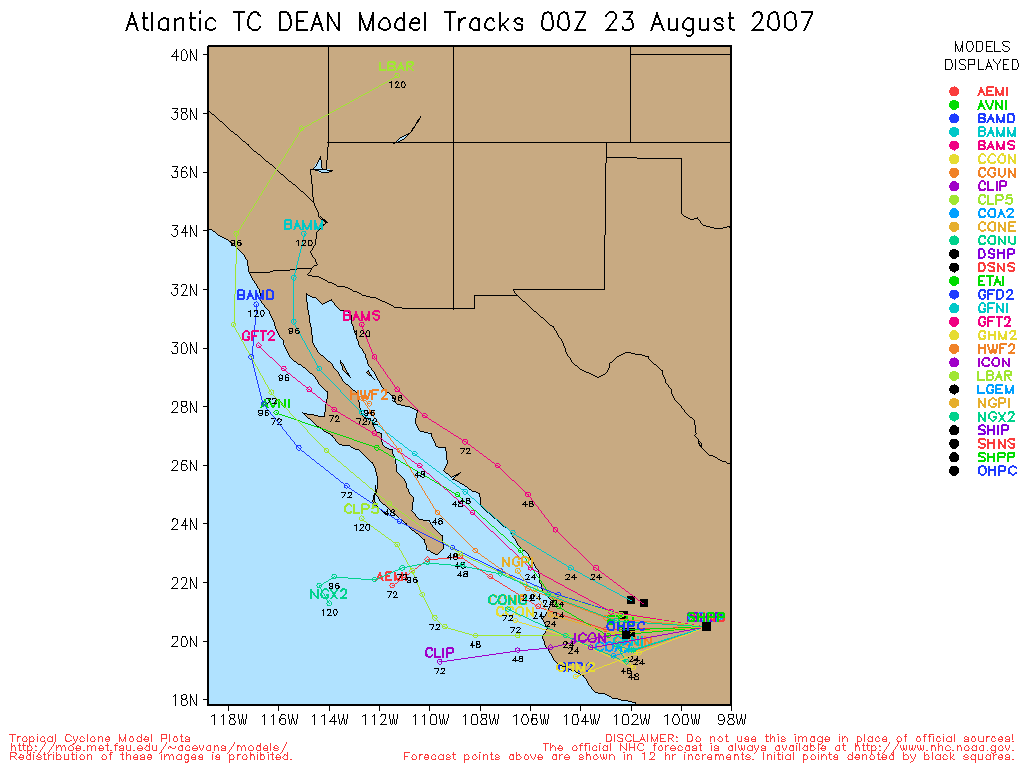
TD#4
12N 31.6W
30MPH 1005mb pressure
moving West at 21MPH
|
LoisCane
Veteran Storm Chaser
Reged:
Posts: 1237
Loc: South Florida
|
|
wow, real cords on Cape Verde Depression.
I'd watch the development more and watch models with a grain of salt for now.
The islands really need to keep on top of this.. as do we all.
--------------------
http://hurricaneharbor.blogspot.com/
|
madmumbler
Storm Tracker
Reged:
Posts: 324
Loc: SWFL
|
|
Quote:
04L:
GFDL is showing this thing growing strong before it hits the windwards. Definately a storm to watch.
Not sure what is up with TCGenisis site - seems to be half broken (the page is unskinned and half the model runs won't load). Cyclone Phase also seems to be lacking data at . Alternative site with the model runs (though looks like the is broken there too):
I saw that too.
I wonder if it's a problem with too much traffic hitting at once?
TWC waited until 11am to announce it's a TD, they didn't mention it 10 minutes earlier during their 10 o'clock hour Tropical Weather update.
--------------------
Lesli in SWFL.
Friends help you move. Real friends help you move bodies.
|
madmumbler
Storm Tracker
Reged:
Posts: 324
Loc: SWFL
|
|
Quote:
There seems to be something brewing out in the Atlantic and I'm having a hard time following some of the technical weather talk that I've been sifting through here. Anyone want to simplify what's going on out there for a weather amateur like myself and let me know how this could possibly have an effect on my trip?
Keep your eyes open and watch the website, , and find out links and information for the local EOC offices in the area you're traveling to. While there, monitor local news outlets.
And if they say leave -- leave.
This thing is too far out to make any accurate predictions at this time beyond "it must be watched."
Lesli.
--------------------
Lesli in SWFL.
Friends help you move. Real friends help you move bodies.
|
Random Chaos
Weather Analyst
Reged:
Posts: 1024
Loc: Maryland
|
|
Just an update on 91L: is saying a TD could form later today or tomorrow, so that bears watching too.
|
wxman007
Meteorologist
Reged:
Posts: 617
Loc: Tuscaloosa, AL
|
|
Aboz,
I am a meteorologist at the NBC affilate for the Destin area, and a long time member here. My advice to you is not to change any plans as yet, and monitor various weather websites such as this one, the web site, and you can also monitor local conditions and see our weather casts here.
Right now there is nothing to get too excited about, but just keep an eye out.
--------------------
Jason Kelley
|
MikeC
Admin
Reged:
Posts: 4667
Loc: Orlando, FL
|
|
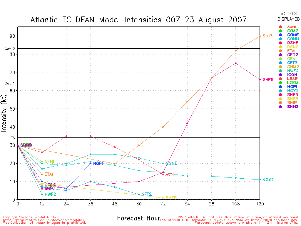
The Gulf system is looking impressive on Satellite, model runs should be interesting to see, especially intensity forecasts. I don't think it will have much time to develop into anything major, but it's the Gulf, in August.
|
wxman007
Meteorologist
Reged:
Posts: 617
Loc: Tuscaloosa, AL
|
|
We, along with our sister station in Tallahassee, are running our own version of the WRF model. We, at the moment, have 2 versions running; an 8km resolution based local run that covers the Panhandle of FL, and a 35km based run of the GOM and Caribbean that runs to 84 hrs (right now)....TD4/Dean is just now entering our domain at 84 hrs. Both models run 4 times daily based on 00, 06, 12, and 18Z data.
You can access our model data here. The usual disclaimers apply...
The Floater (35km run) does show a bit of a surface reflection of something in the GOM, but doesn't develop it much.
--------------------
Jason Kelley
|
danielw
Moderator

Reged:
Posts: 3527
Loc: Hattiesburg,MS (31.3N 89.3W)
|
|
As MikeC said it's August!!!
Quick, satellite observations tell me that a surface/ near surface circulation is/ has formed in/ near the Yucatan Channel since 7AM EDT, my last look at that area.
Still looking for more surface and upper air data. Will post as much as I can, as soon as I can find more data.
http://www.ghcc.msfc.nasa.gov/GOES/goeseastconus.html
Low level circulation center is visible near the NE corner of the Yucatan Peninsula. See attachment above.
Edited by danielw (Mon Aug 13 2007 12:49 PM)
|
OUSHAWN
Weather Guru
Reged:
Posts: 101
Loc: Clear Lake,Tx
|
|
I can see it. It's certainly being influenced by the upper low in the central gulf. Totally exposed over the circulation...all the storm activity is to the the east of it. It looks like to me that the upper low and our circulation center are moving in tandum. If that continues than it seems the sheer would as well. Anyone's thoughts?
Shawn
|


 Threaded


