F
Current Radar or Satellite Image

Flhurricane.com - Central Florida Hurricane Center - Tracking Storms since 1995Hurricanes Without the Hype! Since 1995


Special Tropical Weather Outlook issued for area in the East-Central Atlantic, only with 10% chance for development, not expected to do much.
Days since last H. Landfall - US: Any 239 (Idalia) , Major: 239 (Idalia) Florida - Any: 239 (Idalia) Major: 239 (Idalia)


Archives 2020s >> 2022 News Talkbacks

Pages: 1
MikeCAdministrator
Admin


Reged:
Posts: 4544
Loc: Orlando, FL
Pre-Season Areas
      #114091 - Sun May 22 2022 07:35 PM

2PM EDT 01 June 2022 Update
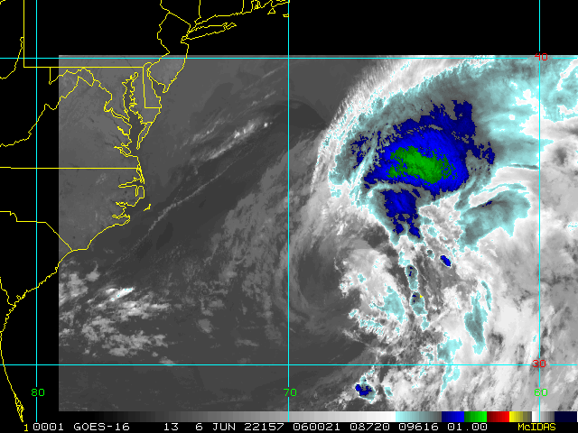
The formerly broad area of low pressure with several individual parts including what was east Pac Hurricane Agatha has become much better defined today, and we now have a good looking 'suspect area,' Invest 91L, in the northwestern Caribbean.

Recon has been tasked to fly into 91L tomorrow, which may already be designated a Tropical Cyclone by that time. The data recon collects will be invaluable in forecasting the system's future track and intensity. For now, models do not have the best handle, but generally take a developing cyclone across south Florida by and over the coming weekend.
-Ciel

2PM EDT 31 May 2022 Update

There is a bit of a jumbled grab bag of low pressure areas now across Central America, the extreme southern Bay of Campeche and the northwestern Caribbean, but it is becoming more obvious that what remains of former Hurricane Agatha is probably going to soon emerge over the southern Gulf of Mexico and be a key player in the weather making this week in the region and heading towards Florida later in the week.

This area of disturbed weather is not yet Invest tagged, but we are now tracking it in a Forecast Lounge titled Agatha and Company . This Lounge will be renamed as warranted (91L, etc.).
- Ciel

6AM EDT 28 May 2022 Update

While the Atlantic Remains Quiet, the first storm of the East Pacific Season has formed and likely will impact southern Mexico as a hurricane. This is Tropical Storm Agatha, and the Government of Mexico has issued a Hurricane Watch for the southern coast of Mexico from Salina Cruz to Punta Maldonado. Agatha is quickly gaining intensity this morning.

Portions of this area is fairly mountainous, but there remains the potential for the remnants of Agatha to re-emerge in or near the Southern Gulf/Bay of Campeche next week, so this system needs to be watched closely for the Atlantic basin later next week.

NHC's East Pacific Info Page

Original Update

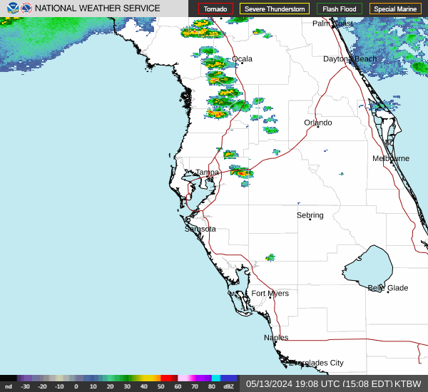
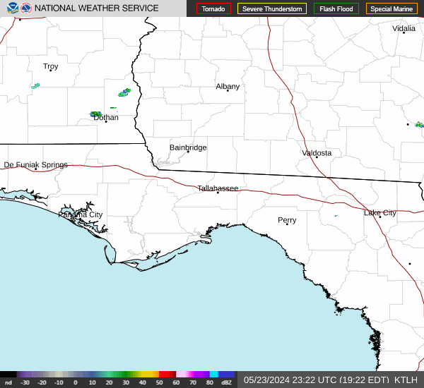
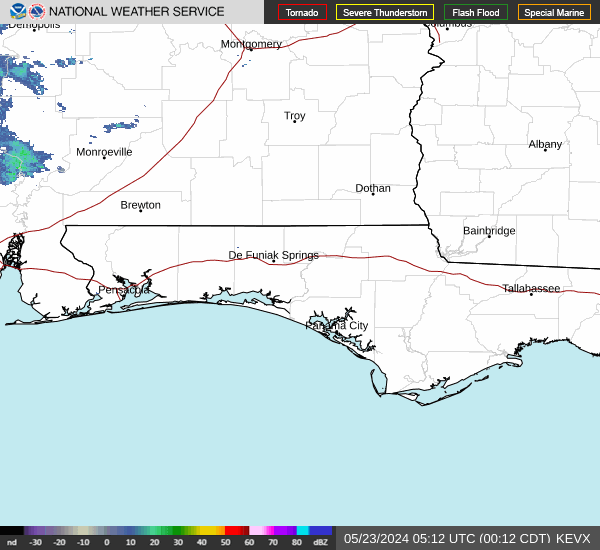
The hybridish disturbance we have been tracking is now being highlighted by NHC as well. Low odds of getting a name, but the weather it produces will be similar, regardless. This is being tracked as Invest 90L. This area only has a 10% chance for development and is unlikely to become named, however those along the northern Gulf coast, those in the western Florida Panhandle and Alabama, should watch it overnight tonight..

This hybrid Low (#90L) in the northern Gulf we are tracking continues to organize and take on more of the features associated with classic subtropical cyclones. In fact, recently there have been some pockets of sustained convection and stronger winds closer to the center - as one would expect in a system becoming more tropical. Interests in the northern Gulf and along the coast may want to continue to monitor this Invest. Moderate to heavy rains, lightning and potentially damaging wind gusts are likely to occur, as well as some risk of waterspouts and tornadoes, regardless of classification.

The official start of the 2022 Hurricane Season is June 1st, the first name on the list is Alex.

More information and discussion about 90L can be found in the Forecast Lounge.


Northeast Gulf Links <html><a href="http://radar.weather.gov/ridge/Conus/southeast_lite_loop.php" onMouseover="ddrivetip('<img src=\'http://radar.weather.gov/ridge/Conus/Loop/southeast_loop.gif\'>');" onMouseout="hideddrivetip();">Southeast Composite Radar Loop</A>

(<a href="http://radar.weather.gov/ridge/Conus/southeast_lite.php" 

onMouseover="ddrivetip('<img src=\'http://radar.weather.gov/ridge/Conus/RadarImg/southeast.gif\>');" onMouseout="hideddrivetip();">Latest Static</a></html>)

<html> <a href="https://radar.weather.gov/ridge/lite/K</html>TBW<html>_loop.gif" onMouseover="ddrivetip('<img src=\'https://radar.weather.gov/ridge/lite/K</html>TBW<html>_loop.gif\'>');" onMouseout="hideddrivetip();"></html>Tampa Bay, FL Radar<html> Radar Loop</A>

(<a href="https://radar.weather.gov/ridge/lite/K</html>TBW<html>_0.gif" onMouseover="ddrivetip('<img src=\'https://radar.weather.gov/ridge/lite/K</html>TBW<html>_0.gif\'>');" onMouseout="hideddrivetip();">Latest Static</a>)</html>

<html> <a href="https://radar.weather.gov/ridge/lite/K</html>BYX<html>_loop.gif" onMouseover="ddrivetip('<img src=\'https://radar.weather.gov/ridge/lite/K</html>BYX<html>_loop.gif\'>');" onMouseout="hideddrivetip();"></html>Key West, FL Radar<html> Radar Loop</A>

(<a href="https://radar.weather.gov/ridge/lite/K</html>BYX<html>_0.gif" onMouseover="ddrivetip('<img src=\'https://radar.weather.gov/ridge/lite/K</html>BYX<html>_0.gif\'>');" onMouseout="hideddrivetip();">Latest Static</a>)</html>

<html> <a href="https://radar.weather.gov/ridge/lite/K</html>MOB<html>_loop.gif" onMouseover="ddrivetip('<img src=\'https://radar.weather.gov/ridge/lite/K</html>MOB<html>_loop.gif\'>');" onMouseout="hideddrivetip();"></html>Mobile, AL Radar<html> Radar Loop</A>

(<a href="https://radar.weather.gov/ridge/lite/K</html>MOB<html>_0.gif" onMouseover="ddrivetip('<img src=\'https://radar.weather.gov/ridge/lite/K</html>MOB<html>_0.gif\'>');" onMouseout="hideddrivetip();">Latest Static</a>)</html>

<html> <a href="https://radar.weather.gov/ridge/lite/K</html>TLH<html>_loop.gif" onMouseover="ddrivetip('<img src=\'https://radar.weather.gov/ridge/lite/K</html>TLH<html>_loop.gif\'>');" onMouseout="hideddrivetip();"></html>Tallahassee FL Radar<html> Radar Loop</A>

(<a href="https://radar.weather.gov/ridge/lite/K</html>TLH<html>_0.gif" onMouseover="ddrivetip('<img src=\'https://radar.weather.gov/ridge/lite/K</html>TLH<html>_0.gif\'>');" onMouseout="hideddrivetip();">Latest Static</a>)</html>

<html> <a href="https://radar.weather.gov/ridge/lite/K</html>EVX<html>_loop.gif" onMouseover="ddrivetip('<img src=\'https://radar.weather.gov/ridge/lite/K</html>EVX<html>_loop.gif\'>');" onMouseout="hideddrivetip();"></html>Northwest Florida Radar<html> Radar Loop</A>

(<a href="https://radar.weather.gov/ridge/lite/K</html>EVX<html>_0.gif" onMouseover="ddrivetip('<img src=\'https://radar.weather.gov/ridge/lite/K</html>EVX<html>_0.gif\'>');" onMouseout="hideddrivetip();">Latest Static</a>)</html>

Gulf of Mexico Satellite Imagery

SFWMD Full Florida Radar (Includes east LA, MS,AL) Loop with Storm Track

Area Forecast Discussions: New Orleans - Mississippi/Alabama/Pensacola - Panhandle/Tallahassee - Tampa/West Central Florida


Edited by CFHC (Thu Jun 02 2022 08:41 PM)


Post Extras: Print Post   Remind Me!   Notify Moderator  
Pages: 1


Extra information
0 registered and 0 anonymous users are browsing this forum.

Moderator:  

Print Topic

Forum Permissions
      You cannot start new topics
      You cannot reply to topics
      HTML is disabled
      UBBCode is enabled

Rating:
Topic views: 2815

Rate this topic

Jump to

Note: This is NOT an official page. It is run by weather hobbyists and should not be used as a replacement for official sources. 
CFHC's main servers are currently located at
Hostdime.com in Orlando, FL.
Image Server Network thanks to Mike Potts and Amazon Web Services. If you have static file hosting space that allows dns aliasing contact us to help out! Some Maps Provided by:
Great thanks to all who donated and everyone who uses the site as well. Site designed for 800x600+ resolution
When in doubt, take the word of the National Hurricane Center