cieldumort
Moderator

Reged:
Posts: 2705
Loc: Austin, Tx
|
|
8:00AM EDT 12 September 2022 Update
Two 20% chance areas in the Atlantic this morning, but nothing imminent. The area in the Central Atlantic was the same area with a low chance last week that came back in the 5 day time frame again. However there is quite a lot of mid level dry air keeping this system week. It's something to watch as it moves west, it may be near the leeward islands of the Caribbean on Thursday or Friday, but will likely still be very weak at the time.
This week is likely to remain quiet in the Tropics, it could change next week potentially, though.
9:00PM EDT 07 September 2022 Update
The most unusual Atlantic hurricane season continues, with presently two, our first two hurricanes of the season, in the Atlantic, with neither actually in the tropics, and there is stark lack of model support advertising that a hurricane will form in the tropics at all this week, the very climatological "peak" of the Atlantic Hurricane Season.
Meanwhile, the hurricane that is actually likely to bring impacts to the United States this week, is over in the "La Niña" eastern Pacific, where Hurricane Kay is expected to bring blustery winds on Thursday to parts of SoCal, not SoFlo, fanning fire dangers there, and before bringing rains and thunderstorms Friday into the weekend. Go figure.
Kay poses significant peripheral threats to the Baja, as well as coastal southern into the interiors of California and Arizona, and Watches and Warnings are already going up.
Quote:
Hurricane Kay Intermediate Advisory Number 14A
SUMMARY OF 600 PM MDT...0000 UTC...INFORMATION
----------------------------------------------
LOCATION...22.6N 113.0W
ABOUT 200 MI...320 KM W OF THE SOUTHERN TIP OF BAJA CALIFORNIA
ABOUT 380 MI...615 KM SSE OF PUNTA EUGENIA MEXICO
MAXIMUM SUSTAINED WINDS...100 MPH...155 KM/H
PRESENT MOVEMENT...NNW OR 340 DEGREES AT 13 MPH...20 KM/H
MINIMUM CENTRAL PRESSURE...971 MB...28.68 INCHES
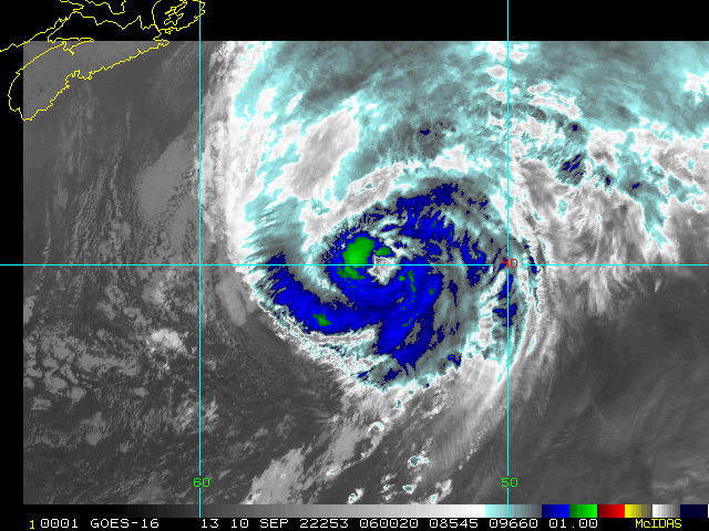
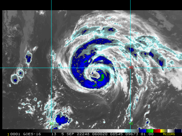
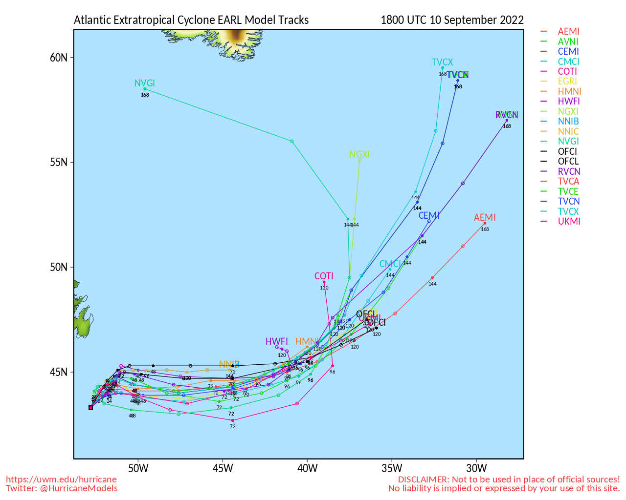
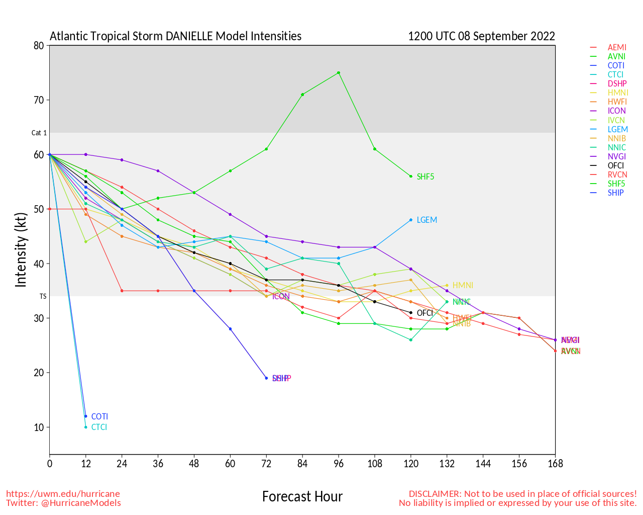
Back in the Atlantic, Hurricane Earl continues to strengthen in the subtropics tonight, and appears to be verifying many models' expectations of going Major. Earl poses a significant threat to Bermuda. To Earl's northeast, Danielle is transitioning into a powerful post-tropical cyclone, and is expected to reach Spain/Portugal early next week, weakening as it does so. Back in the eastern Atlantic, Invest 95L is very likely on the cusp of being classified, perhaps as soon as later tonight even, and behind 95L a wave that could be our next Invest. We are even also watching for a potential quick home-grown spin-up in the Gulf, but conditions there aren't ideal at the moment. All in all, very active tropics. Just not our father's or even our grandfather's La Niña, for sure.
Quote:
Hurricane Earl Intermediate Advisory Number 20A
NWS National Hurricane Center Miami FL AL062022
800 PM AST Wed Sep 07 2022
SUMMARY OF 800 PM AST...0000 UTC...INFORMATION
----------------------------------------------
LOCATION...26.8N 65.5W
ABOUT 390 MI...625 KM S OF BERMUDA
MAXIMUM SUSTAINED WINDS...90 MPH...150 KM/H
PRESENT MOVEMENT...N OR 10 DEGREES AT 8 MPH...13 KM/H
MINIMUM CENTRAL PRESSURE...971 MB...28.67 INCHES
WATCHES AND WARNINGS
SUMMARY OF WATCHES AND WARNINGS IN EFFECT:
A Hurricane Watch is in effect for...
* Bermuda
A Tropical Storm Warning is in effect for...
* Bermuda
Original Update
The Atlantic basin may have been down, but is definitely not out. Tropical Storm and recent hurricane Danielle is likely to become a hurricane again in the north-central Atlantic. And now scraping the northern Leewards and tracking along just north of the Greater Antilles, Tropical Storm Earl is likely to become a hurricane as well, and possibly sooner rather than later. Both have the potential to Major; especially Earl.
While Earl is odds-on to recurve and Danielle is mostly a fish storm, interests in and near the Greater Antilles, Bermuda, as well as in the Azores may want to pay close attention, as any deviation in expected track could put these land areas at real risk for more significant impacts.
Edited by MikeC (Mon Sep 12 2022 07:36 AM)
|
cieldumort
Moderator
Reged:
Posts: 2705
Loc: Austin, Tx
|
|
Public Information Statement
National Weather Service San Diego CA
418 PM PDT Fri Sep 9 2022

...TOP HIGHEST WIND REPORTS...

Location                     Speed     Time/Date       Elevation (ft.)
Cuyamaca Peak                109 MPH   0727 AM 09/09   6500
Big Black Mountain           96 MPH    0925 AM 09/09   4055
Laguna Launch (SDHGPA)       93 MPH    0115 PM 09/09   5711
Sill Hill (SDGE)             91 MPH    0750 AM 09/09   3556
Otay Mountain RAWS           81 MPH    0914 AM 09/09   3283
Hauser Mountain              80 MPH    0900 AM 09/09   3188
Mt Laguna Observatory        80 MPH    0925 AM 09/09   6055
Jamul                        79 MPH    0900 AM 09/09   1105
Toro Peak (HPWREN)           77 MPH    1043 AM 09/09   8689
Pine Cove Rocky Point        76 MPH    1245 PM 09/09   6550
Pine Valley - Horse Launch   75 MPH    0945 AM 09/09   4399
Boucher Hill (HPWREN)        74 MPH    0915 AM 09/09   5439
Rancho Heights (SDGE)        74 MPH    0100 PM 09/09   2195
Fremont Canyon               73 MPH    0251 PM 09/09   1780
|
|


 Threaded


