F
Current Radar or Satellite Image

Flhurricane.com - Central Florida Hurricane Center - Tracking Storms since 1995Hurricanes Without the Hype! Since 1995


Special Tropical Weather Outlook issued for area in the East-Central Atlantic, only with 10% chance for development, not expected to do much.
Days since last H. Landfall - US: Any 238 (Idalia) , Major: 238 (Idalia) Florida - Any: 238 (Idalia) Major: 238 (Idalia)


Archives 2020s >> 2022 News Talkbacks

Pages: 1
cieldumort
Moderator


Reged:
Posts: 2305
Loc: Austin, Tx
Ian en route to a Second CONUS Landfall and Favorable Development Conditions Continue
      #114397 - Fri Sep 30 2022 04:56 AM

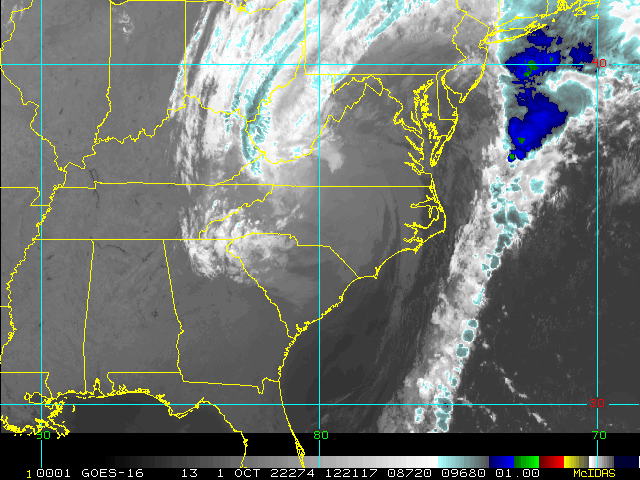
Now a hybrid Hurricane Ian, the cyclone is restrengthening over the very warm waters off the southeast coast along the Gulf Stream, and is now back up to 85 MPH at the time of this post, and still strengthening. Storms like Ian tend to over-perform many models and indeed official forecasts, so residents in Ian's path should prepare for a full Category higher than forecast. That is also always a good thing to do, no matter the storm.

Ian or its remnants may make landfall, move inland, and then reemerge over the the Gulf Stream in a few days, but hopefully by that time up and away. For good.

Elsewhere, conditions across the Atlantic continue generally favorable for additional development. The "it only takes one" doesn't also necessarily mean, "and done."

For in-depth model analysis and a place for more speculative discussions, join us in the Ian Forecast Lounge


Florida Emergency Management


Northeast Gulf Links <html><a href="http://radar.weather.gov/ridge/Conus/southeast_lite_loop.php" onMouseover="ddrivetip('<img src=\'http://radar.weather.gov/ridge/Conus/Loop/southeast_loop.gif\'>');" onMouseout="hideddrivetip();">Southeast Composite Radar Loop</A>

(<a href="http://radar.weather.gov/ridge/Conus/southeast_lite.php" 

onMouseover="ddrivetip('<img src=\'http://radar.weather.gov/ridge/Conus/RadarImg/southeast.gif\>');" onMouseout="hideddrivetip();">Latest Static</a></html>)

<html> <a href="https://radar.weather.gov/ridge/lite/K</html>TBW<html>_loop.gif" onMouseover="ddrivetip('<img src=\'https://radar.weather.gov/ridge/lite/K</html>TBW<html>_loop.gif\'>');" onMouseout="hideddrivetip();"></html>Tampa Bay, FL Radar<html> Radar Loop</A>

(<a href="https://radar.weather.gov/ridge/lite/K</html>TBW<html>_0.gif" onMouseover="ddrivetip('<img src=\'https://radar.weather.gov/ridge/lite/K</html>TBW<html>_0.gif\'>');" onMouseout="hideddrivetip();">Latest Static</a>)</html>

<html> <a href="https://radar.weather.gov/ridge/lite/K</html>BYX<html>_loop.gif" onMouseover="ddrivetip('<img src=\'https://radar.weather.gov/ridge/lite/K</html>BYX<html>_loop.gif\'>');" onMouseout="hideddrivetip();"></html>Key West, FL Radar<html> Radar Loop</A>

(<a href="https://radar.weather.gov/ridge/lite/K</html>BYX<html>_0.gif" onMouseover="ddrivetip('<img src=\'https://radar.weather.gov/ridge/lite/K</html>BYX<html>_0.gif\'>');" onMouseout="hideddrivetip();">Latest Static</a>)</html>

<html> <a href="https://radar.weather.gov/ridge/lite/K</html>MOB<html>_loop.gif" onMouseover="ddrivetip('<img src=\'https://radar.weather.gov/ridge/lite/K</html>MOB<html>_loop.gif\'>');" onMouseout="hideddrivetip();"></html>Mobile, AL Radar<html> Radar Loop</A>

(<a href="https://radar.weather.gov/ridge/lite/K</html>MOB<html>_0.gif" onMouseover="ddrivetip('<img src=\'https://radar.weather.gov/ridge/lite/K</html>MOB<html>_0.gif\'>');" onMouseout="hideddrivetip();">Latest Static</a>)</html>

<html> <a href="https://radar.weather.gov/ridge/lite/K</html>TLH<html>_loop.gif" onMouseover="ddrivetip('<img src=\'https://radar.weather.gov/ridge/lite/K</html>TLH<html>_loop.gif\'>');" onMouseout="hideddrivetip();"></html>Tallahassee FL Radar<html> Radar Loop</A>

(<a href="https://radar.weather.gov/ridge/lite/K</html>TLH<html>_0.gif" onMouseover="ddrivetip('<img src=\'https://radar.weather.gov/ridge/lite/K</html>TLH<html>_0.gif\'>');" onMouseout="hideddrivetip();">Latest Static</a>)</html>

<html> <a href="https://radar.weather.gov/ridge/lite/K</html>EVX<html>_loop.gif" onMouseover="ddrivetip('<img src=\'https://radar.weather.gov/ridge/lite/K</html>EVX<html>_loop.gif\'>');" onMouseout="hideddrivetip();"></html>Northwest Florida Radar<html> Radar Loop</A>

(<a href="https://radar.weather.gov/ridge/lite/K</html>EVX<html>_0.gif" onMouseover="ddrivetip('<img src=\'https://radar.weather.gov/ridge/lite/K</html>EVX<html>_0.gif\'>');" onMouseout="hideddrivetip();">Latest Static</a>)</html>

Gulf of Mexico Satellite Imagery

SFWMD Full Florida Radar (Includes east LA, MS,AL) Loop with Storm Track

Area Forecast Discussions: New Orleans - Mississippi/Alabama/Pensacola - Panhandle/Tallahassee - Tampa/West Central Florida


Post Extras: Print Post   Remind Me!   Notify Moderator  
cieldumort
Moderator


Reged:
Posts: 2305
Loc: Austin, Tx
Re: Ian en route to a Second CONUS Landfall and Favorable Development Conditions Continue [Re: cieldumort]
      #114398 - Fri Sep 30 2022 05:38 AM


Post Extras: Print Post   Remind Me!   Notify Moderator  
Pages: 1


Extra information
0 registered and 0 anonymous users are browsing this forum.

Moderator:  

Print Topic

Forum Permissions
      You cannot start new topics
      You cannot reply to topics
      HTML is disabled
      UBBCode is enabled

Rating:
Topic views: 4286

Rate this topic

Jump to

Note: This is NOT an official page. It is run by weather hobbyists and should not be used as a replacement for official sources. 
CFHC's main servers are currently located at
Hostdime.com in Orlando, FL.
Image Server Network thanks to Mike Potts and Amazon Web Services. If you have static file hosting space that allows dns aliasing contact us to help out! Some Maps Provided by:
Great thanks to all who donated and everyone who uses the site as well. Site designed for 800x600+ resolution
When in doubt, take the word of the National Hurricane Center