cieldumort
Moderator

Reged:
Posts: 2738
Loc: Austin, Tx
|
|
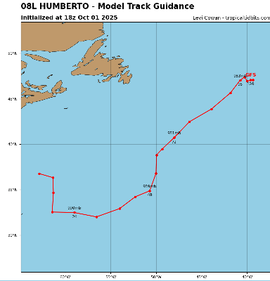
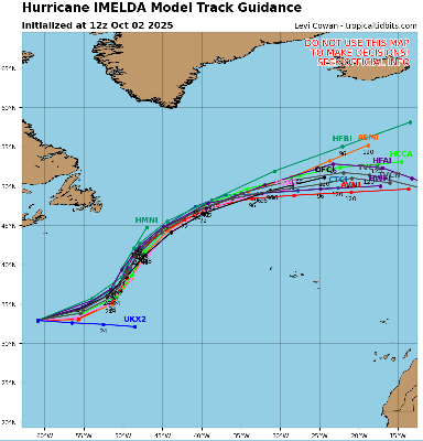
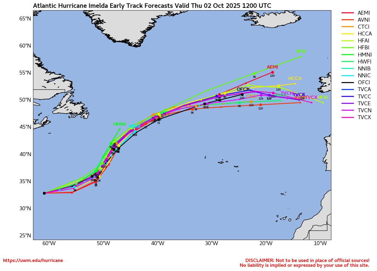
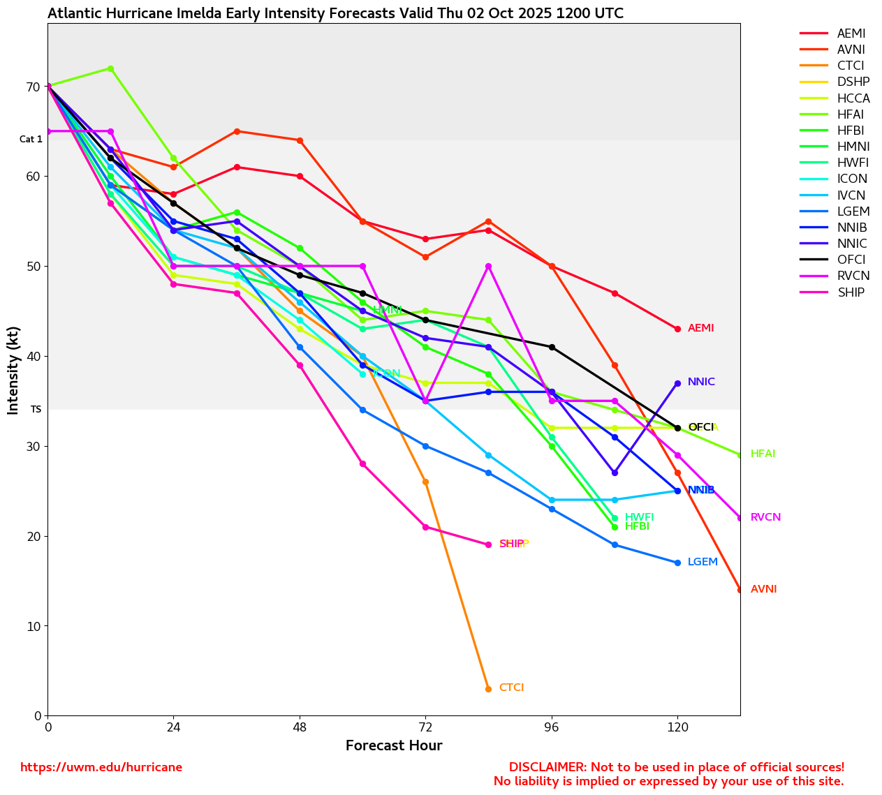
9AM EDT 30 September 2025 Update
Overnight, Imelda continued to organize deep convection despite nearby dry air and occasional dry air intrusions, and has become a stout Cat 1 hurricane. Further strengthening is probable and forecast, although not assured. There is a fair chance of significant strengthening now that Imelda is better organized and could fight off shear and dry air for a while as it tracks towards Bermuda, which all guidance has in its sights between 36-48 or so hours from now. The Hurricane Watch for Bermuda could soon become a Hurricane Warning.
Ciel
5AM EDT 28 September 2025 Update
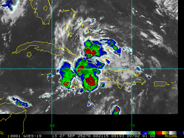
More northerly motion has begun on TD#9 and the models have finally reached a decent consensus, which matches the current forecast track. T#9 is forecast to stay east of Florida (some areas along the east coast may see some squally weather) and make a hard right turn out to sea probably around Daytona and follow Humberto out to sea. Bermuda should watch, but the risk to the southeast TS rapidly decreasing.
11AM EDT 27 September 2025 Update
Tropical Depression Nine has formed.
A Tropical Storm Watch has been issued for the east coast of Florida from the Palm Beach/Martin County Line northward to the Flagler/Volusia County Line.
from discussion:
Given the risk of tropical-storm-force winds along the east coast of
Florida, a Tropical Storm Watch has been issued from the Palm
Beach/Martin County Line northward to the Flagler/Volusia County
Line. Although it is still too early to specify the details of
potential impacts along the remainder of the southeast U.S. coast,
there remains a risk of heavy rainfall, storm surge, and wind
impacts.
10AM EDT 27 September 2025 Update
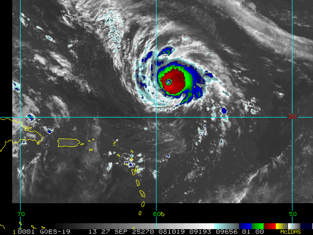
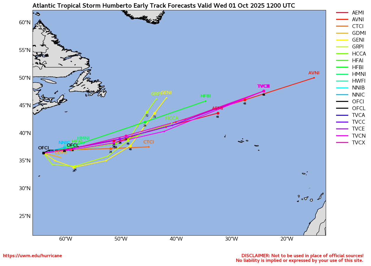
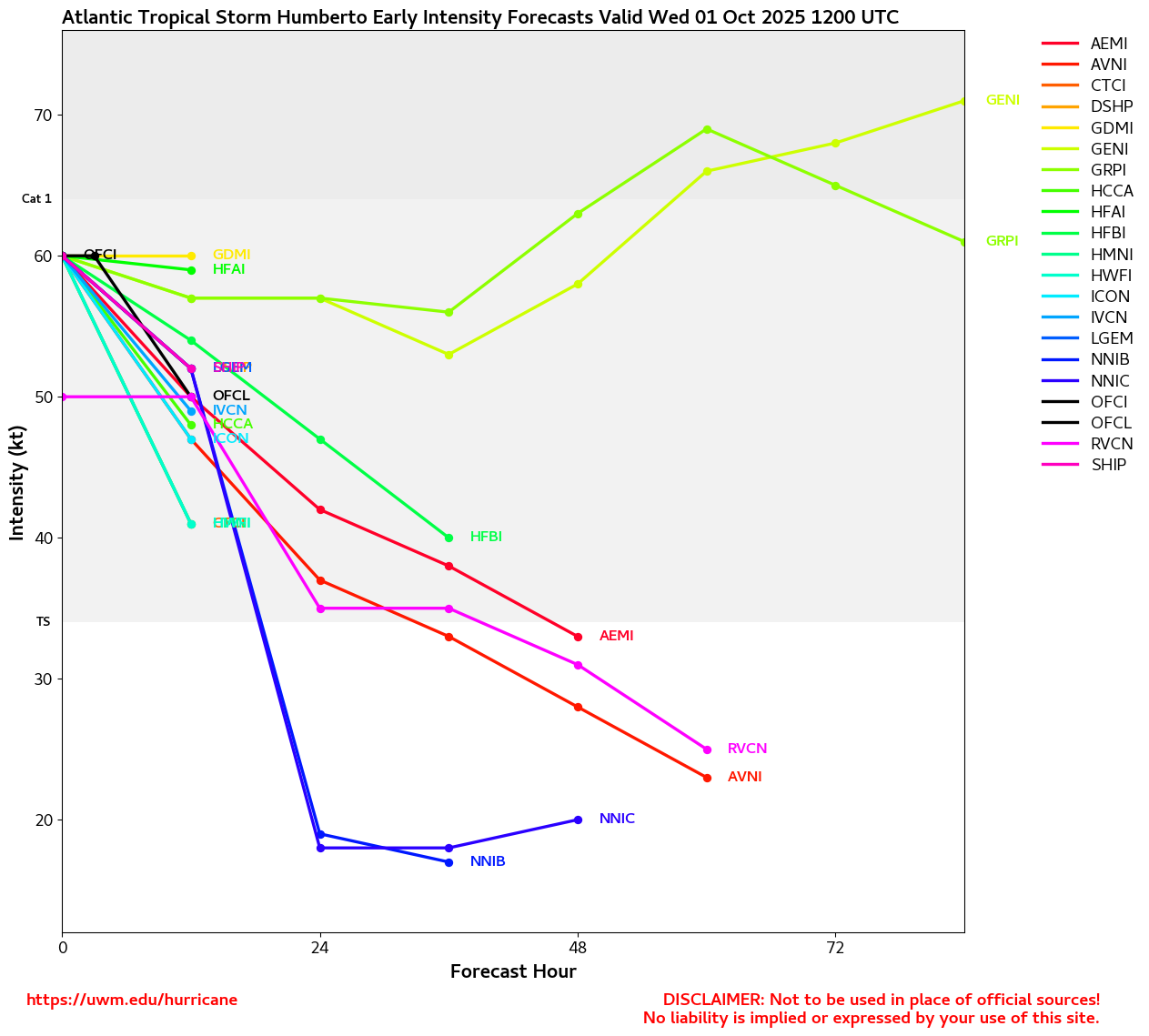
Humberto is now a powerful category 4 hurricane and is forecast to become a 5, the cone takes it north of Bermuda, but those there should monitor it closely.
For PTC9 it may develop later today, and the official forecast stall sit offshore of South Carolina. Tropical Storm Warnings are up for most of the Bahamas this weekend as it will pass through there. Dryer air in the Gulf will likely keep most of the convection and rain away from Florida as it passes by, as the storm doesn't have much on the west side, most areas in Florida won't see any rain from it. Beyond the Bahamas it's currently expected to stall offshore, but possibly close enough to South Carolina for some impacts there, and then head generally out to sea. There's is still a high degree of uncertainty, but that is currently the most likely. Everyone along the southeast and Bermuda should monitor this system, as things could change, especially if the system forms north of forecast or moves faster than forecast since it has not developed yet.
6:40PM EDT 26 September 2025 Update
Advisory packages are now out on NINE (Potential Tropical Cyclone formerly tracked as Invest 94L)
Quote:
Potential Tropical Cyclone Nine Advisory Number 1
NWS National Hurricane Center Miami FL AL092025
500 PM EDT Fri Sep 26 2025
...TROPICAL STORM WATCHES AND WARNINGS ISSUED FOR PORTIONS OF THE BAHAMAS...
WATCHES AND WARNINGS
--------------------
CHANGES WITH THIS ADVISORY:
The government of the Bahamas has issued a Tropical Storm Warning for the central Bahamas and a Tropical Storm Watch for portions of thenorthwestern Bahamas.
SUMMARY OF WATCHES AND WARNINGS IN EFFECT:
A Tropical Storm Warning is in effect for...
* Central Bahamas, including Cat Island, the Exumas, Long Island, Rum Cay, and San Salvador.
A Tropical Storm Watch is in effect for...
* Portions of the northwestern Bahamas, including Eleuthera, New Providence, the Abacos, Berry Islands, and Grand Bahama Island.
Ciel
Original Update
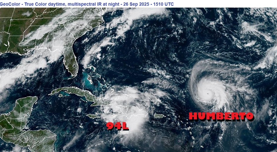
With echos of 2024, after a confounding long duration pause during the "peak" of the season that lulled many into complacency, the Atlantic basin is off to the races as we close out the month of September.
Hurricane Humberto is on the fast track to become a Major, our third of the year, and could accomplish this as soon as this afternoon. The updated track has Bermuda in the Cone as well as potentially the Right Front Quadrant, where more often than not, the strongest weather occurs (wind, rain, flooding, surge, waterspouts, etc). There is a reasonable chance that Humberto reaches mid/high-end Saffir-Simpson Cat 4, and in fact, Cat 5 is not at all out of the question. In addition, Humberto has been growing larger, so impacts will likely be felt on the island regardless of whether or not there is a direct strike.
Invest 94L continues organizing and Advisories could be coming out at any time whether or not a TC has yet formed, as tropical storm/hurricane conditions and storm surge could be coming to the Bahamas and Southeast US within 72 hours. While the ramp for Rapid Intensification does not look as easy for 94L as it appears to be for Humberto, 94L could also become a powerful hurricane. In addition, a PRE (Predecessor Rain Event) is setting up in states along the southeast and portions of the mid-Atlantic. Between the PRE and likely-Imelda-to-be, flooding may become widespread and potentially locally catastrophic. Interests in states such as Georgia, the Carolinas and Virginia may want to begin paying very close attention to official forecasts and warnings for 94L/Imelda, and take all prudent precautions.
Model deep dives and speculations in the Forecast Lounge:
Humberto Forecast Lounge
Imelda Forecast Lounge
Edited by cieldumort (Tue Sep 30 2025 08:57 AM)
|
cieldumort
Moderator
Reged:
Posts: 2738
Loc: Austin, Tx
|
|
PTC NINE is probably organized just enough now to be classified as a Tropical Cyclone
Product: NOAA Vortex Message (URNT12 KWBC)
Transmitted: 27th day of the month at 13:54Z
Agency: National Oceanic and Atmospheric Administration (NOAA)
Aircraft: Lockheed WP-3D Orion (Reg. Num. N42RF)
Storm Number & Year: 09L in 2025
Mission Identifier: Ptc09 (flight in the North Atlantic basin)
Mission Number: 11
Observation Number: 28
A. Time of Center Fix: 27th day of the month at 13:04:10Z
B. Center Fix Coordinates: 22.00N 76.00W
B. Center Fix Location: 129 statute miles (208 km) to the ENE (71°) from Camagüey, Cuba.
C. Minimum Height at Standard Level: 3,144m (10,315ft) at 700mb
D. Minimum Sea Level Pressure: 1007mb (29.74 inHg)
E. Dropsonde Surface Wind at Center: From 125° at 25kts (From the SE at 29mph)
F. Eye Character: Not Available
G. Eye Shape: Not Available
H. Estimated (by SFMR or visually) Maximum Surface Wind Inbound: Not Available
I. Location & Time of the Estimated Maximum Surface Wind Inbound (Undecoded): NA
J. Maximum Flight Level Wind Inbound: From 146° at 27kts (From between the SE and SSE at 31.1mph)
K. Location & Time of the Maximum Flight Level Wind Inbound: 8 nautical miles to the SE (135°) of center fix at 13:02:18Z
L. Estimated (by SFMR or visually) Maximum Surface Wind Outbound: Not Available
M. Location & Time of the Estimated Maximum Surface Wind Outbound (Undecoded): NA
N. Maximum Flight Level Wind Outbound: From 40° at 25kts (From the NE at 28.8mph)
O. Location & Time of the Maximum Flight Level Wind Outbound: 16 nautical miles (18 statute miles) to the NW (314°) of center fix at 13:08:03Z
P. Maximum Flight Level Temp & Pressure Altitude Outside Eye: 10°C (50°F) at a pressure alt. of 3,056m (10,026ft)
Q. Maximum Flight Level Temp & Pressure Altitude Inside Eye: 11°C (52°F) at a pressure alt. of 3,058m (10,033ft)
R. Dewpoint Temp (collected at same location as temp inside eye): 12°C (54°F)
R. Sea Surface Temp (collected at same location as temp inside eye): Not Available
S. Fix Determined By: Penetration, Wind, Pressure and Temperature
S. Fix Level: 700mb
T. Navigational Fix Accuracy: 0.01 nautical miles
T. Meteorological Accuracy: 1.5 nautical miles
Remarks Section:
Maximum Flight Level Wind: 27kts (~ 31.1mph) which was observed 8 nautical miles to the SE (135°) from the flight level center at 13:02:18Z
|
cieldumort
Moderator
Reged:
Posts: 2738
Loc: Austin, Tx
|
|
|
|


 Threaded


