2:30AM EDT 21 October 2025 Update
Advisories are expected to begin at any time today for either Potential Tropical Cyclone, or more likely still, Tropical Storm Melissa.
WARNINGS
...CARIBBEAN GALE WARNING...
Caribbean within 15N68W to 15N69W to 15N70W to 14N68W to 15N68W E to SE winds 30 to 35 KT. Seas 2.5 to 3.0 M.
The Meteorological Service of Jamaica has issued a Severe Weather Alert for the entire island, effective until 5 p.m. on Thursday.
Ciel
8:00PM EDT 20 October 2025 Update
NHC has increased their 2-day development probability that 98L becomes a TC to 90%. Watches and Warnings for locations in the Caribbean could be coming as soon as overnight tonight. Regardless of imminent Watches/Warnings, portions of the ABC Islands can expect heavy rain and strong wind gusts the next few days. Puerto Rico, Hispaniola, Jamaica and Cuba could be looking at even more significant impacts, including the possibility of extreme rainfall totals and very high winds by mid to late week.
The next name on the list this year is Melissa. There is a very real possibility that this system, should it become Melissa as is very likely, gets retired. Interests around the Caribbean should begin considering paying very close attention, monitoring reliable local advisories and forecasts, and keeping abreast of updates from the National Hurricane Center.
Ciel
1:45AM EDT 19 October 2025 Update
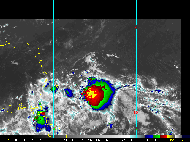
Invest 98L appears to be ramping up tonight.
During the last few frames of daylight satellite imagery, a little LLC could be seen, which could also now be getting nestled underneath persistent deep convection. Additionally, recent scatterometer data shows surface winds likely gusting well into tropical storm force in portions of its eastern side.
Interests in the Lesser Antilles may want to consider making some initial preps for what could be a very stout wave, or even perhaps, if the wave can close off prior to or during passage into the Caribbean, a bona fide tropical storm. TC genesis still looks much more possible once it is in the central to western Caribbean owing to its current fast forward speed, but the chance of development prior to reaching the Caribbean may be going up.
Ciel
Original Update
With occluding fronts rolling into the subtropics and tropical waves still rolling into the tropics, opportunities for development continue into the second half of this back-loaded 2025 Atlantic Hurricane Season. One silver lining, climatology increasingly disfavors mainland US landfalls from October on. However, this is not the case for locations in and around the Caribbean, nor for Bermuda, and systems are still deserving to be watched.
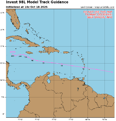
The most impressive wave of two we have been tracking for some time now has just been Invest tagged, 98L. The wave ahead of it also has a chance to develop, but appears to be less than 98's. Interests in and around the Caribbean may want to begin paying closer attention to both of these waves.
Model deep dives and speculation on 98L: 98L Forecast Lounge


 Threaded


