cieldumort
Moderator

Reged:
Posts: 2305
Loc: Austin, Tx
|
|
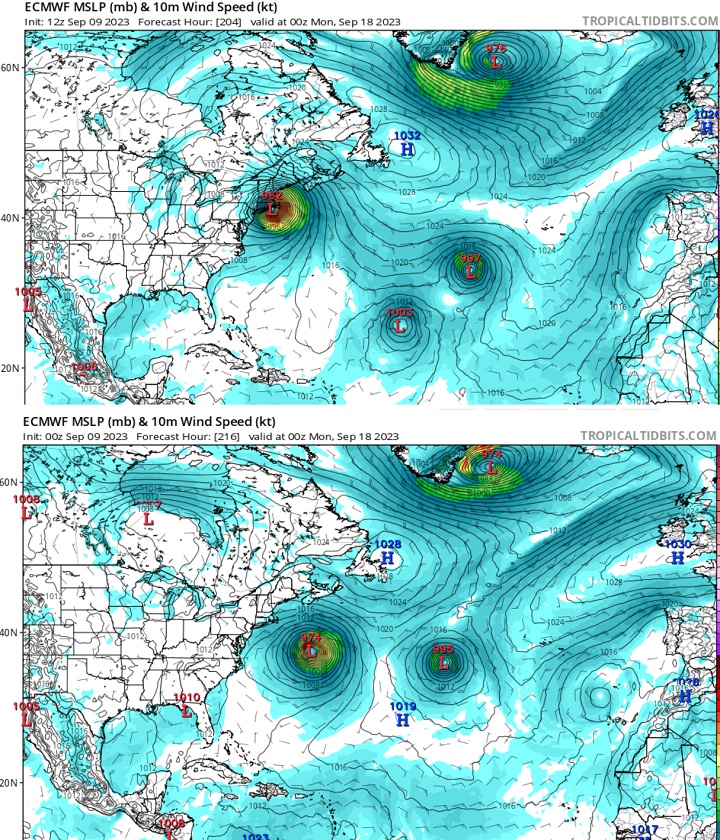
Perhaps the most notable change of potential steering influences in the 12Z vs 0z runs is EURO's now forecast Tropical Storm Nigel replacing what was a 1019mb High. Also noteworthy is the stronger ridge to Lee's north (1032 vs 1028). A lot of Lee's future track may hinge on one or both of these outcomes, and it seems that Lee, Margot and Forecast-Nigel have a bit of a dance to do in order for this to all play out as the 12Z foresees.
|
MikeC
Admin
Reged:
Posts: 4544
Loc: Orlando, FL
|
|
!2z is generally a left shift in all the Models, operationals (Except for Icon which landfalls on Cape Cod) is still Nova Scotia, but further left than prior. The ensemble mean point is now Maine, however.
Latest recon suggestions Lee is back to Major Hurricane strength now, probably officially at 5pm.
12z Euro has shifted west into Western Nova Scotia (not as much as the west shift to Rhode Island yesterday, but still all major models have shifted left today)
|
MikeC
Admin
Reged:
Posts: 4544
Loc: Orlando, FL
|
|
0z Euro showing a bend back west toward cape cod before a Maine landfall, while others are showing Nova Scotia
|
MikeC
Admin
Reged:
Posts: 4544
Loc: Orlando, FL
|
|
Most models have focused toward maine or the western edge of Nova Scotia/ or right up the Bay of Fundy.
However the 18Z euro ensembles have had a pretty significant shitt west, toward Central Maine. and get much closer to Cape Cod which is concerning (not going the right direction). A more pronounced bend back west north of North Carolina. Something to watch, but may be enough for the official track to shift a bit west at 5am if overnight models keeps that up.
|
MikeC
Admin
Reged:
Posts: 4544
Loc: Orlando, FL
|
|
0z shifted left, expect a track shift west at 5AM
|
JMII
Weather Master

Reged:
Posts: 489
Loc: Margate, Florida
|
|
Quote:
Most models have focused toward maine or the western edge of Nova Scotia/ or right up the Bay of Fundy.
Given the Bay of Fundy has the largest tide on earth what is the surge going to be like there?
--------------------
South FL Native... experienced many tropical systems, put up the panels for:
David 79 - Floyd 87 - Andrew 92 - Georges 98 - Frances 04 - Wilma 05 - Matthew 16 - Irma 17
Lost our St James City rental property to Ian 22
|
cieldumort
Moderator
Reged:
Posts: 2305
Loc: Austin, Tx
|
|
Environment Canada:Quote:
c. Surge/Waves.
High waves and elevated water levels will be widespread due to the large size of the storm - the most impacted areas are expected to cover much of the Atlantic coast of mainland Nova Scotia and to a much lesser extent, the Fundy coast of New Brunswick. Wave conditions will also become rough in areas in the western Gulf of St Lawrence / western Northumberland Strait but should remain below warning criteria. This includes all of the east coast of New Brunswick.
For Atlantic coastal Nova Scotia breaking waves of 4-6 metres (15 to 20 feet) are likely. Elevated water levels (storm surge) combined with waves will result in coastal flooding during the high tide late morning to noon Saturday from Shelburne County to eastern Halifax County then again during the high tide late Saturday evening. Water levels up to 1.5 metre (5 feet) above high tide is possible. Storm surge warnings have now been issued from Shelburne County eastward to Guysborough County.
Tropical Cyclone Information Statements
|


 Threaded


