cieldumort
Moderator

Reged:
Posts: 2305
Loc: Austin, Tx
|
|
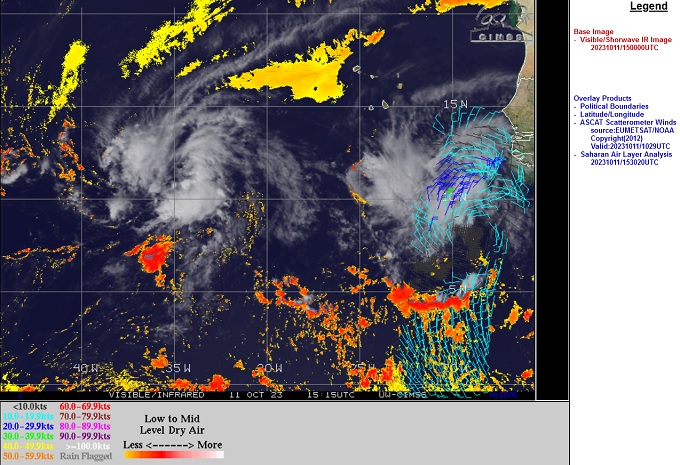
Above: Tropical Storm Sean (L) and Invest 94L (R)
Image cr. CIMSS
A tropical wave that has recently rolled off Africa and is tracking behind now Tropical Storm Sean from his east-southeast, may be one to watch. This wave is fairly well-developed, but presently being held in check from an abundance of dry air and may have a slow start at becoming a TC, thereby potentially keeping it at a lower latitude for longer as it tracks generally west.
Two competing scenarios from the Globals that in their own way make 94L a wave to watch:
1.Some global model runs suggest that 94L will follow well behind Sean, with Sean rounding the western extent of the high pressure currently steering Sean to the west, with that High then building in further westward as Sean exists to the north through an exit created by 93L (or by then perhaps reassigned a new Invest tag - or even name). By days 5-7 in this setup, 94L, or perhaps by then already a weak tropical cyclone, is sent much further west than Sean gets, per these model runs that keep it weak throughout this period.
2. Another possibility comes from runs such as today's 12Z , that weaken Sean , perhaps in the face of shear imparted upon him from approaching 93L, and send a hobbled Sean or his remnants into the northern Caribbean, with steering high pressure again building in from east to west, with the end result also being that 94L gets quite a bit west (and in this scenario, with Sean's remnants ahead of it in the Caribbean).
Lots of time to keep watch on both 94L and now Tropical Storm Sean. This is a rare time of year to see activity coming in from the Cabo Verdes, and there is little historical precedent with which to point to for likely outcomes.
Tropical Storm Tammy - Adv 1 5PM 10/18/23 - Ciel
Edited by cieldumort (Thu Oct 19 2023 12:09 AM)
|
cieldumort
Moderator
Reged:
Posts: 2305
Loc: Austin, Tx
|
|
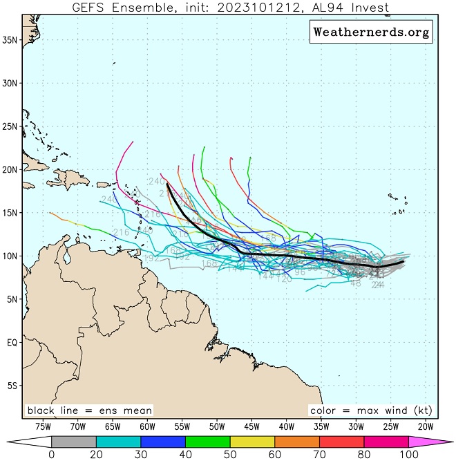
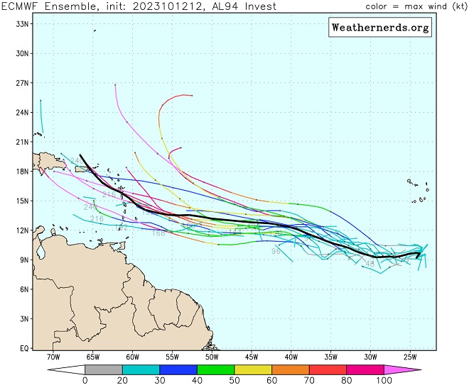
Models increasingly wash out Sean to the northwest of 94L without creating much of an escape hatch for 94L behind him, and instead build high pressure in his place, expanding well to the west, keeping 94L on a generally west to west-northwest heading for several days.
There is strong unanimity among the global models today in this scenario, which could put the eastern Caribbean islands at risk next week should these forecasts hold, and especially so should the more southern ensemble members verify better.
Here are the 12Z Ensemble member plots for both the and (Cr. Weathernerds)
|
cieldumort
Moderator
Reged:
Posts: 2305
Loc: Austin, Tx
|
|
Some flip-flopping today, with more models trending to 94L finding itself a way out to recurve before reaching the Caribbean.
Some 12Z runs so far:
The may have a northward bias as to where TC genesis occurs within the broad low that is 94L. This remains to be seen if it verifies, but in any event, this run has 94L then as a TD or TS forming and recurving well east of the islands next Saturday, the 21st.
The Canadian model develops 94L quicker than the , and perhaps in response to this and Sean's early departure, builds high pressure back in, steering the strengthening tropical cyclone into the Caribbean by next Friday as a hurricane.
The German ICON develops 94L earlier like the Canadian model, but then intensifies the cyclone much more rapidly, and with this deeper vortex, begins pulling poleward prior to reaching the Caribbean as a strong hurricane.
|
IdaliaJackson
Registered User

Reged:
Posts: 7
|
|
Will this reach Atlanta?
|
cieldumort
Moderator
Reged:
Posts: 2305
Loc: Austin, Tx
|
|
The official forecast is for Tammy to recurve well east of the continental U.S. and most computer models agree.
|
cieldumort
Moderator
Reged:
Posts: 2305
Loc: Austin, Tx
|
|
There are some significant model differences beyond Day 3, with a lot of this starting in how the next three days evolve. Some models like the EURO, favor both a shallower Tammy and weaker approaching trof from the west, and have wanted to keep Tammy locked in and trending left of north overall. Others like the , just about the opposite. As pointed out in the 11AM Discussion, the model spread is a whopping 900m at Day 5.
Ultimately, a lot of this may come down to timing, as both Tammy's depth and forward speed have fluctuated off and on, and the approaching trof may or may not catch the cyclone enough to send Tammy off into the wide open Atlantic. Several runs of late have included hooks or loops back towards Bermuda and even the , but with such a wide spread and at so many days out (now talking 5-14), hard to have much confidence in any one of these solutions until there is a better handle on Tammy's structure, track and forward speed in the near term, as well as these of the approaching trof coming off the east coast.
|


 Threaded


