cieldumort
Moderator

Reged:
Posts: 2529
Loc: Austin, Tx
|
|
Models and ensemble members are increasingly warming up to the idea that a broad area of low pressure will form in the western Caribbean or across Central America (in the form of a gyre) next week, and out of this region a tropical cyclone could develop around the end of the month or early November. Generally, operational and ensemble member runs suggest about a 40% chance of TC genesis in this region, which would immediately be landlocked, and as such, we are starting a Lounge on this modeled feature.
More details to come
The modeled broad low pressure area in the Caribbean has formed and has been Invest tagged 97L. The title has been updated accordingly.
2024-11-02 12:00 11.3 -80.7 20
NHC will initiate advisories on Potential Tropical Cyclone Eighteen (97L) at 400 PM EST (2100 UTC), and the title has been updated accordingly.
11-3-24 3:30PM EST
Ciel
|
cieldumort
Moderator

Reged:
Posts: 2529
Loc: Austin, Tx
|
|
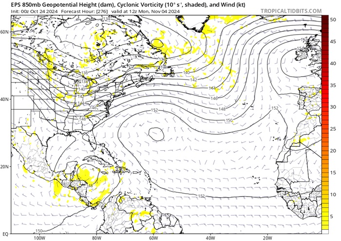
In the EPS model run shown below (image courtesy Tropical Tidbits), an approaching large scale trof crossing the around the time the forecast calls for an area of low pressure (possibly a TC) to exist in the Caribbean would favor pulling up whatever is there to the north or northeast.

Above: EPS* 850mb level forecast initialized 10-24-0z and valid for 11-04-12z
*ECMWF model's Ensemble Prediction System (Singular vectors and an ensemble of data assimilations).
|
IsoFlame
Weather Analyst

Reged:
Posts: 384
Loc: One block off the Atlantic Oce...
|
|
Anything (tropical or hybrid) coming up from the south, then riding along or not far offshore from Florida's east coast will put an exclamation mark on the severe beach erosion we experienced this month in Daytona Beach Shores from being on the north side of Milton's exiting eye followed by a week of nor'easter conditions during King tides.
Today we have a break in the strong onshore flow, and it's forecast to last into the weekend. But the marine forecast ramps wind up again from the NE 15-20 kts on Monday following a dry frontal passage. Models suggest the strong onshore flow could increase through the week. A TC or hybrid system spinning up in early November will enhance the gradient:
--------------------
CoCoRaHS Weather Observer (FL-VL-42) & Surf Forecaster: https://www.surf-station.com/north-florida-surf-forecast-3/
|
IsoFlame
Weather Analyst

Reged:
Posts: 384
Loc: One block off the Atlantic Oce...
|
|
Based on having consistency over multiple runs for several days, I believe that Florida's central east coast a hundred miles or so north and south of the Cape will be in for a week-long period of strong (possibly gale force) onshore wind starting around Halloween and lasting until Election Day. Given the slow movement of the low (potential TC) coming up from the south into the central or northern Bahamas, SST's and increasing shear will probably limit strengthening to a hurricane, though a strong tropical/hybrid storm not too far off the east coast of Florida is quite possible.
This set-up of a late season low coming up from the south, being pinned down by strong high pressure to the north reminds is reminiscent of the Thanksgiving Day coastal wind/erosion event in 1984 that ravaged the central Florida east coast for 4 days.
--------------------
CoCoRaHS Weather Observer (FL-VL-42) & Surf Forecaster: https://www.surf-station.com/north-florida-surf-forecast-3/
|
IsoFlame
Weather Analyst

Reged:
Posts: 384
Loc: One block off the Atlantic Oce...
|
|
Slower evolution of any Caribbean system(s) given last days-worth of modeling. Some runs suggest formation of a pair of lows- one scooting off to the NE and the other pinned down in the Caribbean Sea by a blocking high to the north, so system remains south of the islands strengthening over what Brian Norcross says is currently "the warmest (upper 80's)/deepest water on the planet".
My gut feeling remains about the same... a slowly evolving TC remaining nearly stationary in the Caribbean, then drifting north across Haiti or eastern tip of Cuba into the Bahamas as a tropical storm (possibly becoming a hybrid system) the week after Election Day. That's as far out as I care to conjugate at this time.
Bottom line for the Milton-battered, extremely vulnerable beaches of east central Florida north of the Cape... more coastal erosion likely through Halloween well into November.
--------------------
CoCoRaHS Weather Observer (FL-VL-42) & Surf Forecaster: https://www.surf-station.com/north-florida-surf-forecast-3/
Edited by IsoFlame (Tue Oct 29 2024 01:05 PM)
|
Owlguin
Weather Hobbyist
Reged:
Posts: 73
|
|
Seems like the models are growing a little bit of a consensus with a system emerging from the Caribbean into the southern gulf. Pretty early still though.
|
IsoFlame
Weather Analyst

Reged:
Posts: 384
Loc: One block off the Atlantic Oce...
|
|
Based on the last several days of runs, the weather highlights for the next 2 weeks along Florida's east coast will be a continuation of the past week- an extended period of moderate to strong onshore flow off the Atlantic during multiple high (but thankfully not peak) fall tide cycles.
While having a hard time latching onto any TC organizing, I still believe the environment in the Carribean Sea and Bahamas could support a tropical or hybrid storm- a closed sub-1000 mb low riding the Gulf Stream just offshore along Florida's east coast following Election Day.
The slower evolution of a TC in the Caribbean, followed by a northward movement possibly coinciding with the retreat of a stalled frontal boundary over the Florida peninsula and finally progressive movement of the strong high that has dominated the western Atlantic for weeks will allow the low an escape route as the axis of the high pulls away from Bermuda.
Regardless of what evolves, the ingredients will be in place for moderate to severe coastal impacts. Not good for areas north of the Cape that were battered by Milton's exit just 3 three weeks ago.
--------------------
CoCoRaHS Weather Observer (FL-VL-42) & Surf Forecaster: https://www.surf-station.com/north-florida-surf-forecast-3/
|
cieldumort
Moderator

Reged:
Posts: 2529
Loc: Austin, Tx
|
|
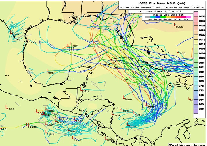
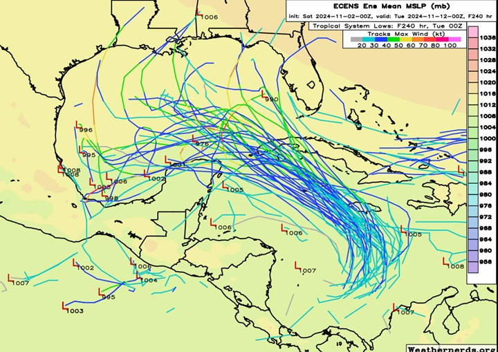
Some early ensemble member runs on what is now Invest 97L from (Top) and (bottom)

Cr. Weathernerds

Cr. Weathernerds
|
bob3d
Weather Hobbyist

Reged:
Posts: 63
Loc: Pasco County, Florida
|
|
Looks like an eastern GOM storm.
--------------------
bob
Time in West Central Florida: 52 years
|
Keith B
Weather Hobbyist
Reged:
Posts: 58
Loc: FL, Orange County
|
|
No thanks Bob. We need a break. : )
--------------------
Keith Boyer N4TRN
Orange County ARES
Asst. Emerg. Coord. (AEC) Skywarn Orange County, FL
http://www.ocares.org/
|
IsoFlame
Weather Analyst

Reged:
Posts: 384
Loc: One block off the Atlantic Oce...
|
|
Quote:
Looks like an eastern GOM storm.
Too early to call with much confidence. Very dependent on how much intensification occurs while in the Caribbean Sea, and the strong/persistent ridge that has held over the east coast (for days on end) finally progressing east out into the Atlantic later in the week. Slower organization in the Caribbean would mean a weaker TC entering the Gulf on a NW then WNW track, staying further off Florida's west coast.
PTC18's current slow northward drift allows for more time to organize and strengthen over the exceptionally warm/deep Caribbean. A period of rapid intensification would then be possible before impacting Cuba. This would also allow more time for the ridge north of the system to weaken/retreat, with a more northerly track closer to Florida as a stronger hurricane.
Given the current forecast uncertainty beyond several days, the Florida panhandle and the peninsula should pay attention to each update early this week until the forecast falls into place.
--------------------
CoCoRaHS Weather Observer (FL-VL-42) & Surf Forecaster: https://www.surf-station.com/north-florida-surf-forecast-3/
|
JMII
Weather Master

Reged:
Posts: 546
Loc: Cape Coral & Margate, FL
|
|
First official forecast cone out of gate points to a central or western GOM landfall. Intensity models are keeping it weak.
--------------------
South FL Native... experienced many tropical systems, put up the panels for:
David 79 - Floyd 87 - Andrew 92 - Georges 98 - Frances 04 - Wilma 05 - Matthew 16 - Irma 17
Lost our St James City rental property to Ian 22
|
IsoFlame
Weather Analyst

Reged:
Posts: 384
Loc: One block off the Atlantic Oce...
|
|
Days 4/5 forecastsr Raphael as a weakening TS. Potential landfall somewhere along the northern Gulf coast, spanning 4 states from tip of the FL panhandle to central LA. From the discussion:
When the system reaches the Gulf of Mexico, the model solutions diverge, which appears to be due to differences in the steering patterns and vertical depth of the storm. The track forecast is largely an update of the previous one and remains close to the various consensus models. However, it should be noted that the track forecast over the Gulf of Mexico is of low confidence. the track forecast over the Gulf of Mexico is of low confidence.
--------------------
CoCoRaHS Weather Observer (FL-VL-42) & Surf Forecaster: https://www.surf-station.com/north-florida-surf-forecast-3/
|
Kraig
Weather Hobbyist

Reged:
Posts: 86
Loc: Jupiter, Fl
|
|
Vortex message at 2:12pmEST
Minimum Sea Level Pressure: 997mb (29.44 inHg) - Extrapolated
Estimated (by SFMR or visually) Maximum Surface Wind Inbound: 42kts (48.3mph)
Estimated (by SFMR or visually) Maximum Surface Wind Outbound: 38kts (43.7mph)
Remarks Section - Additional Remarks...
EYEWALL DEVELOPING NEAR CENTER
Definitely TS Rafael at next update.......
|
IsoFlame
Weather Analyst

Reged:
Posts: 384
Loc: One block off the Atlantic Oce...
|
|
Raphael continues to strengthen, may become a Major ahead of landfall in western Cuba
--------------------
CoCoRaHS Weather Observer (FL-VL-42) & Surf Forecaster: https://www.surf-station.com/north-florida-surf-forecast-3/
Edited by IsoFlame (Wed Nov 06 2024 08:15 AM)
|
JMII
Weather Master

Reged:
Posts: 546
Loc: Cape Coral & Margate, FL
|
|
Its looking really good considering its weak beginnings and questionable formation. The models are completely split on what happens once it reaches the gulf. The good news is all models agree it should weaken massively and could fall apart completely never making landfall in the US.
|
cieldumort
Moderator

Reged:
Posts: 2529
Loc: Austin, Tx
|
|
Impressive stat. Upon restrengthening overnight, Rafael has become the farthest west a November Major has ever gone (Atlantic basin) in our recorded history.
|



 Threaded


