MikeC
Admin
Reged:
Posts: 4677
Loc: Orlando, FL
|
|
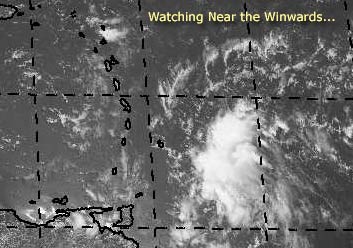
There's a system that could develop east of the Winwards. I'm not too sure it will last if it does though, the environment ahead of it isn't too great to be sustaining a system.
We'll be watching it though.
Mike's Tropical Development Probability Scale
Code:
forget it) 0 1 2 3 4 5 6 7 8 9 10 (sure thing)


          [-----*----------------]
It hasn't reached invest status yet, but we are watching.
Event Related Links
Martinique Radar
The Caribbean Hurricane Page - updates from the islands
Caribbean Island Weather Reports
General Links
NRL Monterey Marine Meteorology Division Forecast Track of Active Systems (Good Forecast Track Graphic and Satellite Photos)
Check the Storm Forum from time to time for comments on any new developing system.
Follow worldwide SST evolution here:
Global SST Animation
NASA GHCC Interactive Satellite images at:
North Atlantic Visible (Daytime Only), Infrared, Water Vapor
Some forecast models:
NGM, AVN, MRF, ETA ECMWF
DoD Weather Models (NOGAPS, AVN, MRF)
AVN, , , , , UKMET
Multi-model plots from WREL
Other commentary at Mike Anderson's East Coast Tropical Weather Center, Independentwx.com, Robert Lightbown/Crown Weather Tropical Update Accuweather's Joe Bastardi (now subcriber only unfortunately), Cyclomax (Rich B.), Hurricane City , mpittweather , Tropical Weather Watchers.Com (JasonM) Gary Gray's Millennium Weather, Barometer Bob's Hurricane Hollow, Snonut,
Even more on the links page.
|
Bobbi
Unregistered
|
|
Maybe like 4.7 or 5.4 ..in that range.
Has a definite twist, yet hard to see what's going on under the cloud cover. Would bet there is no west wind yet indeed, but will there be.
Truth is... that my friends is a real good example of a nice, developing Tropical Wave.
Been a while, but I recognize it.
Wish it would slow down just a drop however at this point one shouldn't argue with success I suppose.
Watching..bobbi
|
Rabbit
Weather Master

Reged:
Posts: 511
Loc: Central Florida
|
|
take a look at this
and this off of Africa
when it looks that organized on IR, you know its strong
could be a TD in a day or so
|
LI Phil
User

Reged:
Posts: 2637
Loc: Long Island (40.7N 73.6W)
|
|
Just watched JBs tropical video...man is he jumping all over 97L. He thinks, with modeling to back it up, that the system is going to head north, over Hispaniola and into the Bahamas by the weekend. A ridge is building in near the Islands, allowing it to sneak through the Antilles towards DR/Haiti. A drops down, but it misses 97L, so it continues it's northwest trek all the way to the Bahamas. At that point, models show it stalling and strengthening, eventually taking aim at the EC.
He's very concerned for the areas from Miami all the way up to NE.
A second scenario keeps 97L on a more southerly track, which would eventually take it either across or just south of Fla and into the GOM. He's not as keen on that one, but it is of course a possibility.
In any event, he thinks this one will be the one and needs to be watched.
Hey bugs, I guess you figured out the "URL" thingy? That wave has TD potential too.
And of course, the GOM is still just waiting to explode.
Cheers,
LI Phil
--------------------
2005 Forecast: 14/7/4
BUCKLE UP!
"If your topic ain't tropic, your post will be toast"
|
Rabbit
Weather Master
Reged:
Posts: 511
Loc: Central Florida
|
|
SPECIAL TROPICAL DISTURBANCE STATEMENT
NWS TPC/NATIONAL HURRICANE CENTER MIAMI FL
215 PM EDT MON JUL 19 2004
SQUALLS ON THE LEADING EDGE OF A TROPICAL WAVE ARE APPROACHING THE
SOUTHERN WINDWARD ISLANDS. AS THESE SQUALLS MOVE THROUGH THE
ISLANDS THIS AFTERNOON AND EVENING THEY WILL LIKELY BE ACCOMPANIED
BY BRIEFLY HEAVY RAINS AND WIND GUSTS TO NEAR TROPICAL STORM FORCE.
THIS SYSTEM HAS SOME POTENTIAL TO DEVELOP INTO A TROPICAL
DEPRESSION OVER THE NEXT DAY OR SO.
FORECASTER FRANKLIN
take a look at this
what i thought yesterday was a weak wave with an outflow boundary appears now to be a developing tropical depression
what i thought was an outflow boundary is actually a strong rain band trying to block the center from the shear
Edited by Rabbit (Mon Jul 19 2004 02:28 PM)
|
bobbi
Unregistered
|
|
Well, I must say Rabbit you're getting good at this.
Thanks for the sites, made me smile.. wasn't really in the mood to but you did.
and.. gee.. got a real system here to think upon don't we?
Took a long lunch and wandered around and came back to see a very vigorous wave.. that deserved a statement.
Can't someone get ship reports or far our island data or something... looks almost like its moving in for the kill.
Bobbi
|
LI Phil
User
Reged:
Posts: 2637
Loc: Long Island (40.7N 73.6W)
|
|
buoy & ship data
--------------------
2005 Forecast: 14/7/4
BUCKLE UP!
"If your topic ain't tropic, your post will be toast"
|
bobbi
Unregistered
|
|
mesmerizing
http://www.ssd.noaa.gov/PS/TROP/DATA/RT/watl-vis-loop.html
|
Rabbit
Weather Master
Reged:
Posts: 511
Loc: Central Florida
|
|
latest carribean radar
|
LI Phil
User
Reged:
Posts: 2637
Loc: Long Island (40.7N 73.6W)
|
|
Here's the link for the National Data Buoy Center, FYI:
NDBC
--------------------
2005 Forecast: 14/7/4
BUCKLE UP!
"If your topic ain't tropic, your post will be toast"
|
Cocoa Beach
Unregistered
|
|
I'm sure most of you have this one, but for those of you that don't:
http://www.srh.noaa.gov/sju/caribm.html
A note:
There is light wind in Trinidad W@5 pressure dropping 29.94
A bit North in Barbados winds are E@17 with slightly higher pressure 29.97.
|
Anonymous
Unregistered
|
|
very cool, Rabbit!
sc 
|
Anonymous
Unregistered
|
|
Looks like closed circulation to me.....east to the north of the center and west to the s...maybe an upgrade soon.....NHC can read the reports too....pressures fairly low considering distance to center....
sc
|
hurricane_run
Storm Tracker

Reged:
Posts: 366
Loc: USA
|
|
look at this ir in the pacific
http://www.ssd.noaa.gov/PS/TROP/DATA/RT/float-ir4-loop.html
Edited by hurricane_run (Mon Jul 19 2004 04:01 PM)
|
bobbi
Unregistered
|
|
Like St. Vincents to start with?
|
Rabbit
Weather Master
Reged:
Posts: 511
Loc: Central Florida
|
|
look at the longitude--that is in the eastern pacific
dont worry, i made that same mistake a few hours ago on another forum site
|
hurricane_run
Storm Tracker
Reged:
Posts: 366
Loc: USA
|
|
ooops thats a mistake on me but it still is worth looking at
|
hurricane_run
Storm Tracker
Reged:
Posts: 366
Loc: USA
|
|
if you look at this ir the correct one you can see has more
convection with it
http://www.ssd.noaa.gov/PS/TROP/DATA/RT/watl-ir2-loop.html
|
bobbi
Unregistered
|
|
wont tell you when i was last excited like this.. dying to know what is going to do at five..
really has a nice explosive look and if it does develop would venture to say its going to have a classic NE quandrant
thanks guys
|
Cocoa Beach
Unregistered
|
|
If you look at the data between these three areas:
Trinidad:
http://weather.noaa.gov/weather/current/TTCP.html
Grenada:
http://weather.noaa.gov/weather/current/TGPY.html
Barbados:
http://weather.noaa.gov/weather/current/TBPB.html
Check out the wind direction, speed, and pressures.
These three locations are within less than 200 miles of each other.
Somethin's a brew'n 
|


 Threaded


