LoisCane
Veteran Storm Chaser

Reged:
Posts: 1236
Loc: South Florida
|
|
Thinking it's premature speculation to say that it could become a major hurricane. It has had problems getting to this point, it is a small storm, the water is not yet percolating under it and it has SAL around it and a ahead of it still and it is supposed to hit shear in a day or so..
http://cimss.ssec.wisc.edu/tropic/real-time/wavetrak/winds/m8g10split.html
One thing to say it will make hurricane or Category 1 and another to speculate yet on it's being a major hurricane.
If it stalls out and spins in the Bahamas under a strong ridge then maybe I'd believe anything but as for right now.. premature speculation I think.
--------------------
http://hurricaneharbor.blogspot.com/
|
Hugh
Senior Storm Chaser
Reged:
Posts: 1060
Loc: Okaloosa County, Florida
|
|
I think alot depends upon how much poleward motion occurs. Right now, there is a definate northward component that did not exist earlier. While a stronger storm would be more likely to move poleward, that would also be more likely to subject the storm to shear from the trough, wouldn't it? Bertha does look very symmetrical right now, but the eye-like feature is no longer visible best I can tell.
--------------------
Hugh
Eloise (1975) - Elena and several other near misses (1985) - Erin & Opal (1995) - Ivan (2004)
|
Random Chaos
Weather Analyst

Reged:
Posts: 1024
Loc: Maryland
|
|
Another SSMIS microwave overpass, with strong central structure.
It is definitely strengthening - take a look:
http://www.nrlmry.navy.mil/tcdat/tc08/AT...N-462W.82pc.jpg
SSD also is now listing it at a 3.5. IR and Microwave is showing a strong band to the north, but none south. Outflow is improving in all quadrants, as seen via SSD IR AVN loop.
I would be surprised if we didn't see a hurricane within the next day based on current trends.
*hopes for a fish spinner*
|
Hugh
Senior Storm Chaser
Reged:
Posts: 1060
Loc: Okaloosa County, Florida
|
|
Based upon that microwave image, and current satellite presentation, I'm going to use the philosophy of "if it looks like a 'cane, it's probably a 'cane"... BUT, if I look at the IR 2 channel satellite loop, and freeze it at the same time as that microwave image, I see a definate eye-like feature there as well. Yet, since then, it's disappeared.
As far as the poleward motion I saw earlier, it may have just been a wobble, because it looks like Bertha is tracking just north of the forecast track, like it's been doing for some time to my eyes.
ETA: Remarkable agreement among the models in the latest run, it appears... and it appears that Bermuda could be visited by Bertha.
--------------------
Hugh
Eloise (1975) - Elena and several other near misses (1985) - Erin & Opal (1995) - Ivan (2004)
Edited by Hugh (Mon Jul 07 2008 01:46 AM)
|
LDH892
Meteorologist
Reged:
Posts: 13
Loc: Carolinas
|
|
On IR it appears that Bertha's motion has been mainly westward over the last 5 hours, just north of the models and forecast points, but no real surprise as these things tend to wobble along a mean track. If the motion continues Bertha may fall back in line with, and even a little south of, the forecast points. IR cloud temps around the center have fallen too and Bertha looks slightly less symmetric, although the circulation appears more vigorous. The new 00Z has Bertha stall out in the western Atlantic around 25-30N and 70W in days 5-7 (Sat.-Mon). Should make for an interesting next few days.
|
cieldumort
Moderator

Reged:
Posts: 2305
Loc: Austin, Tx
|
|
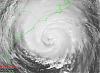
"A picture is worth a thousand words."
No further comment necessary

|
John C
Unregistered
|
|
As of 0500 Bertha is now a hurricae. A news artical should post soon.
|


 Threaded


