MikeC
Admin
Reged:
Posts: 4613
Loc: Orlando, FL
|
|
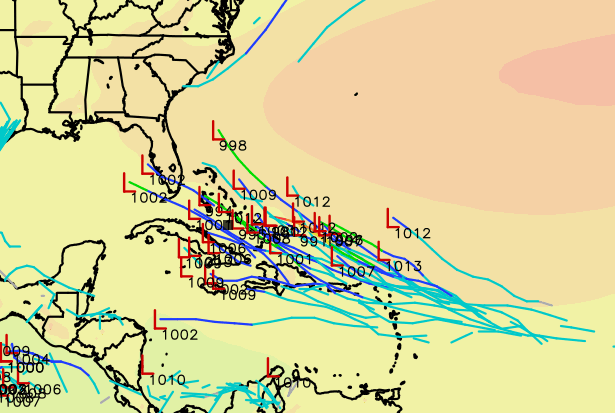
This post covers areas that aren't well known yet, but are mentioned on models.
Starting off there's an area on 12Z showing a depression or tropical storm making landfall near Jacksonville FL Thursday, area matches the weaker area shown on 0z euro (which is more toward Brunswick, GA)
Only thing likely here is some rain for Extreme Northeast FL and/or Georgia Coasts later this week.
12z euro shows this system closer to the Treasure coast of Florida thursday evening, entering the Gulf and making Landfall is eastern Louisiana friday night.
|
MikeC
Admin
Reged:
Posts: 4613
Loc: Orlando, FL
|
|
This area is now tagged on the outlook with a 20% chance for development.
|
MikeC
Admin
Reged:
Posts: 4613
Loc: Orlando, FL
|
|
The general pattern for the longer wave on the outook is the "Caribbean cruiser" system. Meaning it doesn't really recurve at all, and goes right into Central America. This was the pattern suggested by the long range climate models for the long term, so it'll be interesting to see if the 6Z which shows exactly this or not. 0Z Euro and the Canadian GEM model also show it not leaving the Caribbean, but weaker to much weaker than the . If so it's more likely not to get north of the Caribbean than it would. Those in the Leeward islands will want to keep up with this system though, any impacts there probably are around Monday.
|
MikeC
Admin
Reged:
Posts: 4613
Loc: Orlando, FL
|
|
Atlantic wave (40%) 12Z Euro has a cat 3 hitting cozumel in the long range (July 5th)
|
CFHC

Reged:
Posts: 161
Loc: East Central Florida
|
|
Now is invest 95L
|
MikeC
Admin
Reged:
Posts: 4613
Loc: Orlando, FL
|
|
After Beryl, not much going on model wise other than the Icon trying to hint at Something off the East Coast of Florida on Friday, but not really shown on any other model.
|
MikeC
Admin
Reged:
Posts: 4613
Loc: Orlando, FL
|
|
Well And Euro (and ensembles) show it also now after 12Z, just weak and short lived though, heads up toward the SE North Carolina Coastline.
|
MikeC
Admin
Reged:
Posts: 4613
Loc: Orlando, FL
|
|
Not much, but a hint of activity in the first week of August on the long range Euro ensembles, coming slowly from a wave currently over Africa.
|
MikeC
Admin
Reged:
Posts: 4613
Loc: Orlando, FL
|
|
12z euro shows this over the bahams now later in the cycle, but not really any other models, except one member of the ensemble. Again just something to potentially watch mid to late next week.
|
MikeC
Admin
Reged:
Posts: 4613
Loc: Orlando, FL
|
|
Euro is alone on this, but interesting for late next week
|
MikeC
Admin
Reged:
Posts: 4613
Loc: Orlando, FL
|
|
0Z Euro has much less activity in the ensembles and nothing really significant on the operational run. So chances seem to be a little less this morning, still worth watching.
|
MikeC
Admin
Reged:
Posts: 4613
Loc: Orlando, FL
|
|
0z Euro Ensembles are a bit more active today. shows the system now, but it goes into the Gulf (late developer). Timelines, if anything were to get it near Florida it would likely be around next Saturday (August 3rd).
GFS and Canadian show the area now too, although gets it into the Gulf near Louisiana as a TD/TS, Euro near Mobile, AL as a TS, Canadian near the Florida Pandhandle after crossing the Keys as a wave or TD. Although all the models it doesn't develop until late in the run.
|
MikeC
Admin
Reged:
Posts: 4613
Loc: Orlando, FL
|
|
This area now is on the outlook as a 20% area. AS the 12Z euro stretches it out and doesn't really develop it now, some of the ensembles still have it. Worth watching next week regardless.
|
IsoFlame
Weather Analyst

Reged:
Posts: 330
Loc: One block off the Atlantic Oce...
|
|
Regardless of whether it develops, or is sacrificial in the current unfavorable conditions, the projected track steered by a persistent ridge of high pressure in our general direction will probably set the stage for what could be a congo-line of systems as August progresses.
--------------------
CoCoRaHS Weather Observer (FL-VL-42) & Surf Forecaster: https://www.surf-station.com/north-florida-surf-forecast-3/
|
MikeC
Admin
Reged:
Posts: 4613
Loc: Orlando, FL
|
|
More info about the Central Atlantic Area has moved here
https://flhurricane.com/cyclone/showflat.php?Number=114989&gonew=1#UNREAD
|
CFHC
Reged:
Posts: 161
Loc: East Central Florida
|
|
12z and now 18Z show another wave forming in the Caribbean after PTC4.
|
MikeC
Admin
Reged:
Posts: 4613
Loc: Orlando, FL
|
|
Newer area now has a 40% chance to develop. Models are all east of the US now, but do go through the Caribbean islands, and some through the Bahamas.
|
MikeC
Admin
Reged:
Posts: 4613
Loc: Orlando, FL
|
|
Long range has picked up overnight, with all major models developing the system marked as a 20% area. The 6z has a major hurricane landfall in Tampa Bay.
|
IsoFlame
Weather Analyst
Reged:
Posts: 330
Loc: One block off the Atlantic Oce...
|
|
Initially, not much (if any) development in the central Atlantic, then potentially rapid when system enters the eastern Caribbean. Check out the following links illustrating the uncharacteristically rapid cooling in the equatorial Atlantic (could there be a teleconnection for why systems are not strengthening to the north in the MDR?):
cooling rate
cool region
--------------------
CoCoRaHS Weather Observer (FL-VL-42) & Surf Forecaster: https://www.surf-station.com/north-florida-surf-forecast-3/
|
IsoFlame
Weather Analyst
Reged:
Posts: 330
Loc: One block off the Atlantic Oce...
|
|
My gut feeling is that we need to closely watch our backyard for short-notice, home-grown tropical cyclogenesis instead of the keying in on MDR long-track systems in the 2024 season's version of "weird". Last run of the suggested that both the western Atlantic and the Gulf could spin up significant TC's rather quickly given the exceptionally ripe environment in early September.
--------------------
CoCoRaHS Weather Observer (FL-VL-42) & Surf Forecaster: https://www.surf-station.com/north-florida-surf-forecast-3/
|


 Threaded


