cieldumort
Moderator

Reged:
Posts: 2706
Loc: Austin, Tx
|
|
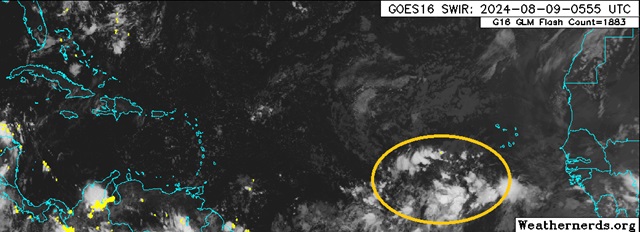
Modeling continues to point to improving background conditions for development as we head towards the climatological peak, and a tropical wave located a few hundred miles west-southwest of the Cabo Verdes increasingly looks likely to become our next Invest and potentially also named storm.
Steering currents favor a track that would take this system, developed or not, towards the Greater Antilles and Bahamas, then depending on how well formed it is as well as how much high pressure to its north is built in, may ultimately pose a threat to the and/or Bermuda and/or Canada. Despite the fact that there is nothing here more than a wave at this time, given that models nearly unanimously develop this feature and suggest it poses a threat to land, we are starting a Lounge at this time.
NHC odds for development as of this post are 0% within 48 hours and 50% within 7 days.
As noted, this wave is not yet Invest-tagged, but any status changes will be updated to the title as warranted.
As of 2024-08-10-0Z this wave is now being tracked as an Invest (98L) and the title has been updated accordingly
Ciel
Edited by MikeC (Mon Aug 12 2024 03:31 PM)
|
IsoFlame
Weather Analyst

Reged:
Posts: 414
Loc: One block off the Atlantic Oce...
|
|
Quote:
Steering currents favor a track that would take this system, developed or not, towards the Greater Antilles and Bahamas, then depending on how well formed it is as well as how much high pressure to its north is built in, may ultimately pose a threat to the and/or Bermuda and/or Canada.
Just like with Debby's early pre-depression formation when consensus was east of Florida, right now I don't have confidence in current modeling suggesting recurve east of Florida. My "gut feeling" is that the Atlantic high that has been dominant this season will persist, keeping the slow to develop system on a W/WNW track (below 20N) for longer. Once the system becomes , the later turn NW around the western extension of the ridge will potentially threaten the Florida peninsula (like with Debby), then possibly the panhandle or Big Bend region (the 3rd time in less than a year!).
Edited by IsoFlame (Fri Aug 09 2024 09:35 AM)
|
CFHC

Reged:
Posts: 209
Loc: East Central Florida
|
|
Setup here prefers the east of US Track if the system strengthens early, if not you get something like today's 12Z where it slips under then landfalls around Wilmington NC on Aug 18/19th. Canadian is much stronger, and stays east of Bermuda and recurves before it reaches the Caribbean islands.
Basically it's a case for the "weaker west" "stronger east" setup.
Icon is in between those two, and the 0z Euro gets close to Bermuda but stays east of the US mainland (after going over the USVI and PR) but then curves back toward MA/ME at the end of the run.
|
bob3d
Weather Hobbyist

Reged:
Posts: 65
Loc: Pasco County, Florida
|
|
Quote:
Just like with Debby's early pre-depression formation when consensus was east of Florida, right now I don't have confidence in current modeling suggesting recurve east of Florida. My "gut feeling" is that the Atlantic high that has been dominant this season will persist, keeping the slow to develop system on a W/WNW track (below 20N) for longer. Once the system becomes , the later turn NW around the western extension of the ridge will potentially threaten the Florida peninsula (like with Debby), then possibly the panhandle or Big Bend region (the 3rd time in less than a year!).
I have a hard time believing a more easterly path is likely with the strong Atlantic high in place and in my opinion will move this system further west before it recurves to the north. A path similar to Debby seems to me to be more plausible.
--------------------
bob
Time in West Central Florida: 52 years
|
MikeC
Admin
Reged:
Posts: 4835
Loc: Orlando, FL
|
|
0z icon tonight is fairly far right, it only clips the northern leewards and then recurves well before the Bahamas/Turks and Caicos ending close to Bermuda
0z is a little left/south and gets into Hispaniola on this run, which is an uhoh for weaker/west. It does get into the turks and caicos and southeastern bahamas then manages to stay offshore of the US (And avoid Bermuda) and go out to sea.
The 0z Canadian goes out to sea before it reaches the Leeward islands and never directly affects land.
The 0z Euro goes through the leewards, over puerto Rico then turns north, avoids Bermuda at the last minute and goes out to sea.
The 6z is stronger than 0z, but is a similar track to it, out to sea, although may get all the way to the Azores on the trip back east, a sign it may be a very long lived system.
Troughing seems strong enough to keep the system away from the mainland US, (at least the southeast and mid-Atlantic, but it'll likely recurve enough to avoid north of there also)
|
IsoFlame
Weather Analyst
Reged:
Posts: 414
Loc: One block off the Atlantic Oce...
|
|
Back and forth on timing of strengthening. Latest further east.
One thing is nearly certain, if/when 98L becomes and if/when tracks over the western Atlantic east of the Bahamas, rapid intensification to major while recurving likely, possibly threatening Bermuda.
--------------------
CoCoRaHS Weather Observer (FL-VL-42) & Surf Forecaster: https://www.surf-station.com/north-florida-surf-forecast-3/
|
MikeC
Admin
Reged:
Posts: 4835
Loc: Orlando, FL
|
|
12z models are mostly to the right, is the furthest west/left, but none come close to the US mainland on this run. 18Z earlies also generally shifted right, with Bermuda becoming the longer range threat. The short term is how it'll do with the Caribbean islands, although the Canadian still recurves before reaching it, all the other models get it into the Leewards. There is a chance the Northeast or Atlantic Canada sees something from it though.
|
IdaliaJackson
Verified CFHC User

Reged:
Posts: 18
|
|
Quote:
Quote:
Just like with Debby's early pre-depression formation when consensus was east of Florida, right now I don't have confidence in current modeling suggesting recurve east of Florida. My "gut feeling" is that the Atlantic high that has been dominant this season will persist, keeping the slow to develop system on a W/WNW track (below 20N) for longer. Once the system becomes , the later turn NW around the western extension of the ridge will potentially threaten the Florida peninsula (like with Debby), then possibly the panhandle or Big Bend region (the 3rd time in less than a year!).
I have a hard time believing a more easterly path is likely with the strong Atlantic high in place and in my opinion will move this system further west before it recurves to the north. A path similar to Debby seems to me to be more plausible.
JFL everything is pointing after the NE Caribbean graze it's going OTS then to Canada
|
MikeC
Admin
Reged:
Posts: 4835
Loc: Orlando, FL
|
|
It's looking even less likely for Bahamas and US impacts this morning, but models are either taking it through the northern Leeward islands or just to the north of them and then moving generally toward or just east of Bermuda. /Euro/Canadian keep the system east of Puerto Rico also, and only the Icon moves it toward Hispaniola now. Canadian still doesn't even reach the leeward islands or Bermuda. Although a lot of ensembles still take the system over Puerto Rico. The Virgin Islands may get more from it.
.
|
IsoFlame
Weather Analyst
Reged:
Posts: 414
Loc: One block off the Atlantic Oce...
|
|
A large upper level low in the Atlantic between Bermuda and PTC5 is an interesting feature:
water vapor
Following PTC5/Ernesto, strong areas of convection continue to push off Africa into the eastern Atlantic. The MDR Congo line is kicking in gear.
Edited by IsoFlame (Mon Aug 12 2024 08:15 AM)
|
cieldumort
Moderator
Reged:
Posts: 2706
Loc: Austin, Tx
|
|
So far, is arguably more sharp wave with a transient and jumpy low level center, than what one might typically expect to see with a tropical cyclone. The nascent tropical cyclone is definitely feeling the impacts of a very rapid forward speed and perhaps also some trade wind divergence. These strongly challenging factors may not only result in delaying and slowing significant development, as we have already seen, but also westward adjustment to its current and future track.
|
Robert
Weather Analyst

Reged:
Posts: 371
Loc: Southeast, FL
|
|
.
Edited by Robert (Tue Aug 13 2024 10:37 AM)
|


 Threaded


