cieldumort
Moderator

Reged:
Posts: 2705
Loc: Austin, Tx
|
|
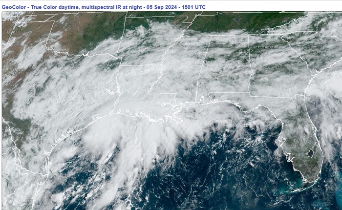
An elongated area of low pressure we have been watching for several days in the northwestern Gulf has pretty much freed itself of frontal association and continues tightening up this morning, and it appears to be closed off or just about closed off. With abundant moisture to work with and a window of low to moderate shear, this system may become a tropical depression or storm prior to being impinged upon by an approaching front. Regardless of development, conditions very similar to a wet tropical depression or even storm are likely to be on the rise across the region.
This feature is not yet Invest-tagged by but could soon be.
More details to come.
This feature has just been Invest-tagged, 90L, and the title has been updated accordingly.
Synoptic Time Latitude Longitude Intensity
2024-09-05 18:00 28.0 -95.1 25
-Ciel
Edited by cieldumort (Fri Sep 20 2024 02:39 PM)
|
cieldumort
Moderator
Reged:
Posts: 2705
Loc: Austin, Tx
|
|
As this Low is not yet Invest-tagged, vort-centric model runs have not been initiated. However, we can still look at some of the mesoscale runs and globals. These mesoscale runs, particularly the Convection Allowing Models (CAMs), should be considered with some additional caution.
Here is an overview of some of the runs out today.
15z HRRR (CAM): Initializes 1010mb Low and drifts it southwest today off the coast of south Texas. Hooks it back towards the northwest Friday as an apparent Tropical Storm located south of the TX/LA border. 996mb high-end TS/borderline Cat 1 overnight Friday while south of Louisiana, heading east.
12z NAM3K (CAM): Sloppy, elongated double-barrel Low along Texas coast that reorganizes off of southeast Texas Thursday night/Friday morning. Apparent weak TS midday Friday southeast of Brownsville, TX and swirls offshore around there until end of run 18Z Saturday as a strong TS.
12z HWRF (CAM): Sloppy, elongated double-barrel Low in the NW GOM that never tightens up and remains stretched out through end of run Saturday 12Z
12z : Continues the trend we've already been seeing of tightening up. Apparent TD by midday Friday while south of TX/LA border. Maybe a TS by midday Saturday and tracks south, eventually washing out and getting overrun by the approaching wave.
12z ICON: Doesn't develop it but sends it south to merge with the approaching wave that, once combined, does develop and heads back north as a developing system making landfall on Louisiana next Thursday.
|
cieldumort
Moderator
Reged:
Posts: 2705
Loc: Austin, Tx
|
|
18z hurricane models are rolling out on 90L (vort-centric)
HWRF, HMON, HAFS-A and HAFS-B unanimously develop 90L and send it south-southwest over the next few days. Caveat: These tend to perform better when a system has already become a bona fide TC.
18z HWRF 1005mb TD/borderline TS by midday Friday while well east of the central TX coast. Continues south and begins deforming and merging with the approaching tropical wave. Combined, they make a landfall of sorts late Monday night south of Brownsville, TX as a strong disturbance.
18z HMON 1001mb TD/TS by mid afternoon Friday while well east of the central TX coast. Continues intensifying into a strong TS by midday Saturday while meandering well offshore of the central TX coast. Possibly becomes H1 while southeast of Brownsville overnight Saturday. Looks to wash out east of Tampico, MX by Monday morning.
18z HAFS-A Tropical Storm late tonight while just offshore of Freeport, TX, meanders and heads southward becoming a high-end TS/borderline H1 by predawn Saturday well offshore of the central TX coast. Cat 2 well southeast of Brownsville, TX late Saturday night. Meanders, weakens, merges with approaching wave and makes landfall south of Brownsville as a stout disturbance or possible weak TS midday Tuesday.
18z HAFS-B Weak Tropical Storm southeast of Matagorda, TX mid-morning Friday, heading south. Strong TS by midday Saturday while well east of Brownsville, TX. Skirts central MX coastline, merges and deforms with approaching wave with an apparent final landfall as a stout disturbance south of Brownsville, TX overnight Monday.
|
cieldumort
Moderator
Reged:
Posts: 2705
Loc: Austin, Tx
|
|
90L has become reattached to its parent front once again and does not appear to be tracking south nearly far enough or fast enough to outrun the approach of a secondary boundary set to interact with it, and its chances for solo development have been dropping rapidly today. However, a portion of 90L may interact with the approaching wave crossing the Yucatan this weekend and assigns a 40% chance of development in the Bay of Campeche from either the wave itself or interaction with 90L and/or also the first front.
If this all sounds messy, it is. Under normal circumstances at this time of year, 90L could have easily developed by now, and to think that yet another Code Orange for what I suppose may get Invest tagged 91L is going to develop while 90L hasn't seems like a stretch given all we have seen of late.
Still, something to watch. If there is a new Invest worth tracking we will start a new Lounge on it. Models were bullish on 90L and some still are, so I wouldn't completely ignore this Low, either.
Please also see Watching for home-grown tropical cyclogenesis in early Sept
|
cieldumort
Moderator
Reged:
Posts: 2705
Loc: Austin, Tx
|
|
ASCAT from 1629z today shows that old 90L is still alive and at a minimum is participating in the evolution and steering flow of more recently Invest-tagged 91L to its south. It remains possible that it has an outsized impact.
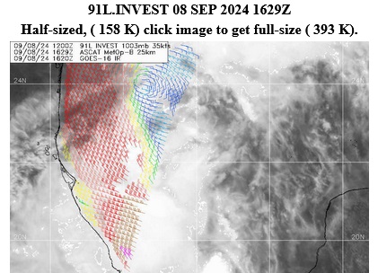
Above: ASCAT 9/8/24/1629z for Invest 91L actually showing off 90L's well-defined circulation
|
cieldumort
Moderator
Reged:
Posts: 2705
Loc: Austin, Tx
|
|
Link to the Francine Forecast Lounge. Invest 90L has become a major player in the tropical storm's evolution and looks to have about a 50/50 shot of either being the dominant circulation or at the very least, continue merging with what was Invest 91L, to congeal closer to 's earlier track forecast center line.
So that this Lounge itself can be referenced without a risk of breaking things, we will leave it on its own, but for all practical intents and purposes, is part of the Francine Lounge.
|


 Threaded


